 Translate




Note: All building and development in unincorporated Clackamas County must be done consistently with the Zoning and Development Ordinance. The Zoning and Development Ordinance is a part of this Code. It can be obtained from:
Clackamas County Department of Transportation and Development
150 Beavercreek Rd., Oregon City, OR 97045
(503) 742-4400 Voice
The Zoning and Development Ordinance can also be accessed on the internet.
Table of Contents
- 11.01 County Surveyor Review Standards
- 11.01.010 Purpose
- 11.01.020 Plat Boundary Survey and Other Requirements
- 11.01.030 Final Plat Requirements
- 11.01.040 Property Line Adjustments
- 11.02 Delegation Of Authority To Accept Certain Interest In Land Dedicated On Partition Plats; Delegation Of Subdivision Plat Approval Authority.
- 11.02.010 Purpose
- 11.02.020 Dedications in Conjunction with Land Partitions
- 11.02.030 Updating Official Road Registers
- 11.02.040 Designation of Authorized Persons
- 11.02.050 Further Delegations of Authority
- 11.02.060 Modifications to Designations of Authorized Persons
- 11.02.070 Savings Clause
- 11.03 Transportation System Development Charge
- 11.03.010 Purpose
- 11.03.020 Definitions
- 11.03.030 Application
- 11.03.040 Collection
- 11.03.050 Credit
- 11.03.060 Refunds
- 11.03.070 Dedicated Funds, Project List
- 11.03.080 Appeal
- 11.03.090 Annual Review
Chapter 11.01: County Surveyor Plat Review Standards
11.01.010 Purpose
The purpose of this chapter is to establish standards and requirements for the review and approval of survey maps, partition plats, condominium plats, subdivision plats, property line adjustments and replats of partitions, condominiums, subdivisions, and cemeteries for the following reasons:
A. The review and approval of survey maps, partition plats, condominium plats, subdivision plats and replats of partitions, condominiums, subdivisions, and cemeteries in an accurate, efficient, consistent and timely manner is necessary for the promotion of economic development and protection of property rights; and
B. Although benefiting the public in general, such services are user oriented. The long standing policy of the Board is that the most fair and sound method of ensuring adequate funding of such services is a user fee not to exceed the reasonable estimate of actual County Surveyor costs.
[Codified by Ord. 05-2000, 7/13/00; Amended by Ord. 01-2018, 2/22/18]
11.01.020 Plat Boundary Survey and Other Requirements
In addition to the requirements of ORS Chapters 92, 94, 100, and 209, and other applicable laws, chapters, and rules, the following shall be provided:
A. For subdivision and condominium plats, a final boundary survey map of the proposed plat, accompanied by the report required in subsection B of this section, shall be submitted to the County Surveyor a minimum of 30 days prior to the submission of the final plat. If warranted, the County Surveyor may waive this requirement.
1. In addition to the requirements of ORS 209.250, the survey map shall show all obvious encroachments or hiatuses created by deeds, building, fences, cultivation, occupation, previous surveys and plats and any other conditions that may indicate ownership lines as surveyed may be different than those shown on the survey;
2. Any encroachment or hiatus affecting any partition plat submitted for review shall be brought to the attention of the County Surveyor at the time of submittal;
3. The County Surveyor may refuse to approve a plat if the County Surveyor finds an encroachment or hiatus. Evidence that the encroachment or hiatus has been eliminated may be required prior to final plat approval.
B. All partition, condominium, or subdivision plats submitted for approval shall be accompanied by a report, issued by a title insurance company, or agent authorized to perform such services in Oregon, setting forth ownership and all easements of record, together with a copy of the current deed, easements, and restrictions for the platted property and copies of the deeds for all abutting properties, and other documentation as required by the County Surveyor. The report shall have been issued no more than 15 days prior to the submittal to the County Surveyor of the survey map or plat. The County Surveyor may require a supplemental report. Condominium plats shall be submitted with a copy of the condominium declaration. Prior to approval of a condominium plat, the final version of the condominium declaration, approved by the State of Oregon, shall be submitted.
C. All partition, condominium, and subdivision final plats, including those inside city limits, shall be checked and approved by the County Surveyor. Items to be checked include, but are not limited to, compliance with Oregon Statutes, city and county ordinances, proper boundary resolution, and resolution of apparent gaps and overlaps. If the city has chosen to have the plat checking service performed by a city surveyor under ORS 92.100(1), the County Surveyor shall perform an office review and indicate approval on the plat. The fee for performing this service shall be established by resolution of the Board of County Commissioners. No plat shall be recorded without the approval of the County Surveyor.
D. The actual approval, or notice of intent to approve, of a plat by the County Surveyor shall be valid for 30 days only, unless recorded prior to the 30 day expiration.
E. Centerline monuments of public and private roads created by any subdivision or partition plat shall be placed in a monument box meeting the specifications of the County Surveyor. Said monument boxes shall be placed at locations as determined by the surveyor preparing the subdivision or partition and approved by the County Surveyor. In accordance with ORS 92.060(2), the point of intersection of the curve may be set in lieu of the beginning and ending points. The County Surveyor may authorize the setting of another type of monument in circumstances where setting the required monument is impracticable. If a phasing plan and schedule allow final plat review to occur in two or more phases, each of which includes a portion of the subject property, is approved by the local government with land use planning jurisdiction, it shall be submitted to the County Surveyor for review of the phasing sequencing and lot numbering. The lot numbering shall be continuous and connected from phase to phase.
[Codified by Ord. 05-2000, 7/13/00; Amended by Ord. 05-2004, 4/8/04; Amended by Ord. 01-2018, 2/22/18]
11.01.030 Final Plat Requirements
A. If a preliminary plat for a subdivision, partition, or replat is approved by the local government with land use planning jurisdiction, then finalizing the subdivision, partition, condominium or replat requires the completion of a final plat review pursuant to section 11.01.030(B), except that a final plat is not required for a partition in which all parcels are larger than 80 acres. In all cases, the form and content of the final plat or replat shall comply with the local government with land use jurisdiction's final decision approving the subdivision or partition application and applicable provisions of Chapters 11.01 and 11.02 of the County Code, ORS Chapter 92, 94 and 100 and ORS 209.250.
B. Unless waived by the County Surveyor, the final plat shall contain, at a minimum, the following information:
1. The lines and names of all streets and other public ways, parks, playgrounds, and easements dedicated to the public or granted for the use of the owners within the plat and to whom the easement will be conveyed;
2. The length and bearings of all straight lines, curves, radii, arcs, and the semi-tangents of all curves. Line tables and curve tables are subject to approval by the County Surveyor.
3. All dimensions along the lot lines of each lot or parcel, to the nearest hundredth of a foot, with the bearings and any other data necessary for the location of any lot line in the field.
4. Suitable primary control points, approved by the County Surveyor, and description and ties to these control points, to which all dimensions, angles, bearings, and similar data given on the plat shall be referred.
5. The location and complete physical descriptions of all permanent monuments found or set, including full physical descriptions of Public Land Survey Corners (monument and accessories) shown on the plat. Record references for the found monuments shall be cited.
6. The plat numbers and, if applicable, names of all platted subdivisions, partitions, condominiums, and cemeteries, and the legal numbers and names of all roads adjacent to the plat.
7. The date(s) monuments were set (so identified), the date(s) the final plat was prepared (so identified), a north arrow, and graphical engineering scales.
8. The boundary of the divided land, with the bearings, curves, and distances marked, as determined by a field survey made by an Oregon registered professional land surveyor, and to close with a mathematical linear error of closure of not more than one foot in 10,000 feet. In addition, the survey shall be performed with the reference to the Federal Geodetic Control Committee guidelines for third order class II.
9. Any easements, restrictions, or notes required by the County, City, or other public service providers and the locations, widths, and purposes of all proposed easements and existing easements of record, including instrument numbers. For any non-public (private) easements the beneficiary, access, use and maintenance shall be noted on the plat or discussed in detail in a separately recorded document that will be noted on the final plat. All access from the plat to a public road shall be shown.
10. Open space and common ownerships shall be labeled on the final plat as tracts. Labeling of tracts shall be alphabetical beginning with the letter "A", and no missing letters shall be allowed. The ownership, purpose, use, and maintenance of tracts shall be identified on the plat. In addition, a deed conveying the tract to the intended recipients shall accompany the final plat mylar and be recorded immediately after the plat and noted on the plat.
C. All declarations for a planned community, articles of incorporation, bylaws, easements, maintenance agreements, or other similar items required or proposed shall be submitted with the final plat for review by the County Surveyor.
1. The County Surveyor shall not approve the final plat until any applicable declarations for a planned community, articles of incorporation, bylaws easements, maintenance agreements, or other similar items required or proposed have been approved by the County Surveyor and are filed with the appropriate state agency, if necessary.
2. The declaration for a planned community, articles of incorporation and bylaws shall be consistent with ORS Chapter 92, 94 and 100, if appropriate.
3. When applicable, a certificate of formation of a nonprofit corporation, with a state seal, for the homeowners association shall be submitted with the final plat.
4. Easements created by or within the declaration for a planned community and any additional restrictions shall be noted on the final plat.
D. Review and recording of the final plat shall be as follows:
1. The County Surveyor shall submit the final plat to the Planning Director for review.
2. Unless waived by the County Surveyor, after Planning Director approval, the final plat shall be submitted to the County Assessor for review and approval, as well as the County Road Official for review and approval when final plat is for a subdivision.
3. After signature by the County Surveyor, the Planning Director, the County Assessor and, if necessary, the County Road Official, the final plat shall be submitted to the County Clerk for recording. When the County Clerk is satisfied with the final plat, it shall be signed, assigned a permanent file number, and place in the permanent plat records of the County.
[Added by Ord. 01-2018, 2/22/18]
11.01.040 Property Line Adjustments
A. The record of survey memo map shall be filed with the County pursuant to the standards and procedures of the County Surveyor's Office and relevant provisions of ORS Chapters 92 and 209. Additionally, revised legal descriptions of the properties affected by the adjustment (for new deeds) shall be prepared by a registered professional land surveyor, refer to the record of survey map that is filed with the County, and be recorded with the County Clerk.
B. A property line adjustment deed shall contain the names of the parties, the description of the adjusted line, references to original recorded documents, and signatures of all parties with proper acknowledgement.
[Added by Ord. 01-2018, 2/22/18]
Chapter 11.02: Delegation of Authority to Accept Certain Interest in Land Dedicated on Partition Plats; Delegation of Subdivision Plat Approval Authority.
11.02.010 Purpose
It is the purpose of this chapter to delegate the Board of Commissioners' authority to approve subdivision plats, and to accept certain dedications of interests in land for road, drainage, utility, sidewalk, or signing related purposes from members of the public, in order to reduce delays for local development projects, to simplify the final formal requirements for approval prior to recording, and to reduce staff time and expenses incurred in the process of seeking Board acceptance. The authority granted in this Chapter is in addition to any other grants of authority to County officers to acquire interests in real property on behalf of the County.
[Added by Ord. 06-2004, 4/8/04]
11.02.020 Dedications in Conjunction with Land Partitions
When made in conjunction with land partitions, dedications of interests for road, drainage, utility, sidewalk, or signing related purposes may be completed by specific notation on the face of the partition, without need for a separate deed.
[Added by Ord. 06-2004, 4/8/04]
11.02.030 Updating Official Road Registers
Each time a new right-of-way dedication of any nature that abuts an existing County road or local access road is accepted under this Chapter, the County's official road register for these County or local access roads shall be updated by the staff of the person in possession of and responsible for that road register, in order to reflect acquisition of the new interest in land. The person accepting the new dedication under the authority of this Chapter must promptly communicate with the person in possession of and responsible for the affected road register, advising them to update it to reflect the new acceptance. [Added by Ord. 06-2004, 4/8/04; Amended by Ord. 03-2022, 7/21/22]
11.02.040 Designation of Authorized Persons
The Board of County Commissioners delegates authority to each of the following persons and their written designee(s) to accept dedications of public rights-of-way and related or appurtenant easements on behalf of the County when made on the face of a partition plat under this Chapter, and to approve subdivision plats on behalf of the Board of County Commissioners:
A. The County Surveyor; or
B. If the County Surveyor is unavailable, then the Deputy County Surveyor.
[Added by Ord. 06-2004, 4/8/04; Amended by Ord. 03-2006, 6/22/06]
11.02.050 Further Delegations of Authority
The persons designated in Section 11.02.040 may, from time to time, make a further delegation of the authority granted by this Chapter, to another County staff person or another County staff person's designee upon approval of the County Administrator. Such further delegations must be limited in duration, and must be in writing. Any further delegation from the persons designated in Section 11.02.040, written or otherwise, that purports to be a permanent delegation of the authority granted by this chapter shall be null and void.
[Added by Ord. 06-2004, 4/8/04]
11.02.060 Modifications to Designations of Authorized Persons
The designations of authorized persons and delegations of authority in this Chapter may be modified at any time by ordinance of the Board of County Commissioners.
[Added by Ord. 06-2004, 4/8/04]
11.02.070 Savings Clause
Should any section, clause, phrase or word in this Chapter be held to be invalid or unenforceable by a court of competent jurisdiction, it shall not affect the validity of the remainder of this Chapter. All portions of this Chapter not stricken under the court's decision shall continue in full force and effect.
[Added by Ord. 06-2004, 4/8/04]
Chapter 11.03: Transportation System Development Charge
11.03.010 Purpose
A. New Development within Unincorporated Clackamas County contributes to the need for increased capacity on transportation facilities and related improvements, and therefore should contribute to the funding for such facilities. The TSDC will fund a portion of the needed auto, bicycle and pedestrian system capacity for New Development.
B. ORS 223.297 through 223.314 grant the County the authority to impose a TSDC to equitably spread the costs of essential capacity increasing capital improvements to New Development. The County may enact one or more charges in areas that are smaller than the entire unincorporated County.
C. The TSDC is incurred upon the issuance of a permit to develop property at a specific use or density. The TSDC is separate from other fees provided by law or imposed as a condition of development. It is a fee for service because it relates a development's fee to receipt of services based upon the nature of that development.
D. The TSDC is not a tax on property or on a property owner as a direct consequence of ownership of property within the meaning of Section 11b, Article XI of the Oregon Constitution or the legislation implementing that section.
E. The TSDC shall be established and may be revised by resolution of the Board. The resolution shall set the amount of the charges (Rate Schedule), the Methodology for calculating the charges, and the list of TSDC Capital Improvement Projects intended to be funded by Improvement Fees (referred to as the TSDC Capital Project List).
F. The TSDC constitutes a mandatory collection method based upon the guidelines set forth in ORS 223.297 – 223.314, and is intended as a financing mechanism for the increased transportation system capacity associated with New Development, and does not represent a means to fund maintenance of existing roads.
[Codified by Ord. 05-2000, 7/13/00; Amended by Ord. 01-2002, 1/10/02; Amended by Ord. 02-2002, 2/28/02; Amended by Ord. 10-2012, 10/24/12; Amended by Ord. 12-2017, 11/30/17]
11.03.020 Definitions
All terms not defined below shall be defined by the permitting jurisdiction in the Clackamas County Zoning and Development Ordinance.
A. ACCESSORY DWELLING UNIT means a unit complying with Clackamas County ZDO 839. Accessory Dwelling Units will be charged the adopted rate for the Institute of Transportation Engineers (ITE) classification of "220 - Apartment."
B. AFFILIATE is any entity that directly controls, is controlled by or under common control with the applicant. As used herein, the term "control" or "controlled by" means the power to direct the management of such entity through voting rights, ownership or contractual obligations.
C. ARTERIAL means that term as defined and used in Chapter 5 - Transportation System Plan of the County Comprehensive Plan.
D. AVERAGE WEEKDAY TRIPS means the average 24-hour total of all vehicle trips counted to and from a study site from Monday through Friday. Average Weekday Trips are calculated by using the Institute of Transportation Engineers (ITE) Manual or as otherwise provided by this Chapter.
E. ASSIGNMENT refers to the transfer of a credit voucher or portion of a credit voucher that is transferred to another party.
F. BOARD means the Board of County Commissioners of Clackamas County, Oregon.
G. BUILDING OFFICIAL means that person, or their designee, certified by the State and designated as such to administer the State Building Codes for the County.
H. BUILDING PERMIT means that permit issued by the Building Official pursuant to the most recently published versions of the State of Oregon Structural Specialty Code, and the Oregon Residential Specialty Code. In addition, Building Permit shall mean the Manufactured Home Installation Permit issued by the Building Official, relating to the placement of manufactured homes.
I. BUS TRANSIT CORRIDOR includes current fixed-route public bus service (excludes dial-a-ride shuttles and taxi service).
J. COLLECTOR means that term as defined and used in Chapter 5 – Transportation System Plan of the County Comprehensive Plan.
K. COMPREHENSIVE PLAN means the County generalized, coordinated land use map and policy statement that interrelates all functional and natural systems and activities relating to the use of lands, including but not limited to sewer and water systems, transportation facilities, recreational and natural resources and air and water quality management programs.
L. CONSTRUCTION COST INDEX means that index published by the Engineering News Record (ENR) Northwest (Seattle, Washington) titled "Construction Cost Index."
M. CONTIGUOUS means that a property and an improvement or portion thereof share a common boundary line. A determination of contiguous includes all property subject to the development approval. The boundary lines and area of an improvement shall be determined by the Right-Of-Way and easement areas for the improvement. In addition, multiple properties under common ownership separated by features such as a common area, non-motorized vehicle or pedestrian way, creek, wetland, park, or similar areas; up to a distance of not more than 100 feet between the properties at the boundary with the improvement, are deemed to include the feature in their combined boundary line. Any portion of an improvement that is located beyond the frontage of a property, as determined by the extension of boundary lines perpendicular to the frontage of the property, is not deemed to be contiguous to that property. An intersection improvement shall be deemed contiguous to all property with frontage on the intersection, or that touches the intersection at a point.
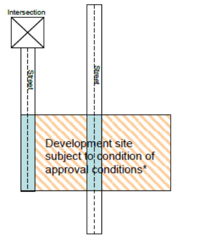
All intersection and street improvements are conditions of development approval. Shaded portion of streets are considered Contiguous to the development site; remainder of streets and intersection are non-contiguous.
* "Contiguous" is defined based on frontage of site prior to subdivision or partition.
N. COUNTY means Clackamas County, Oregon.
O. DEVELOPMENT AGREEMENT means the tool the County may use to secure the developer's compliance with the commitment to build-out a phased master-plan project, qualifying the initial phases for a reduction under the Station Area and/or Mixed-Use reduction provisions.
P. DEVELOPMENT PERMIT means a grading, excavation, engineering, building, land use or similar permit issued by the County that approves New Development as defined by this ordinance.
Q. DEPARTMENT means the Clackamas County Department of Transportation and Development.
R. DEPARTMENT DIRECTOR means the Director of the Clackamas County Department of Transportation and Development, or their designee.
S. FLOOR AREA RATIO (FAR) means the ratio of the total amount of enclosed Gross Floor Area within a structure to the amount of buildable acreage. For purposes of calculation, both floor area and net site area shall be converted to square feet. (For example, a single-story building constructed on one-quarter of the net developable site would have a floor area ratio of 0.25. If a second story were added, the floor area ratio would increase to 0.50, etc.)
T. GROSS FLOOR AREA for the purposes of this ordinance will mirror the definition in the most recent ITE Trip Generation Manual.
U. GUEST HOME means a unit complying with Clackamas County ZDO 833.
V. HEARINGS OFFICER is defined as the Hearings Officer for the Department, or other official as appointed by the Board.
W. IMPROVEMENT FEE means a fee for costs associated with capital improvements to be constructed.
X. INTERNAL CAPTURE RATE is defined as a percent reduction of trip generation for component land uses to account for trips made internally on site. A reduction of trip generation rates can potentially decrease traffic impact and help reduce external congestion. The Internal Capture Rate is the percent reduction of trip generation estimates for land uses to account for trips made internally on a Mixed-Use Development site.
Y. ITE TRIP GENERATION MANUAL means the most recently published edition of the manual entitled Trip Generation, published by the Institute of Transportation Engineers. A copy of the ITE Trip Generation Manual shall be kept on file with the Department
Z. LIGHT RAIL TRANSIT STATION AREA is defined as the passenger station platform along a fixed-route light rail alignment.
AA. LEGAL COUNSEL means the Office of County Counsel for Clackamas County, Oregon.
BB. LONG TERM FINANCING means debt instruments issued by the County or a component unit to finance a capital improvement in accordance with applicable state law.
CC. METHODOLOGY means the narrative, formulas and charts that serve as the framework for determining the TSDC.
DD. MIXED-USE DEVELOPMENT is generally planned as a single real-estate land development project with a structure, or structures, containing two or more different and interacting land uses. These areas are characteristically higher density, compact walkable areas. Mixing of uses typically includes residential (townhomes, apartments, or detached homes on small lots), retail (mostly specialty and convenience), restaurants, hotels, office buildings, movie theatres, and any other compatible and complimentary uses. For further definition of project requirements to qualify for a Mixed-Use Development reduction, reference Table 2 – Mixed-Use Development TSDC Reduction Requirements, in Section 11.03.030(G).
EE. MULTI-MODAL means vehicular, transit, bicycle, pedestrian and wheel chair transportation.
FF. NEW DEVELOPMENT means site improvements that increase overall trip generation.
GG. QUALIFIED PUBLIC IMPROVEMENT means a capital improvement that is required as a condition of development approval, identified in the TSDC Capital Project List adopted by resolution and is:
a. Not located on or Contiguous to the New Development site, or
b. Located on or Contiguous to the New Development site, and as demonstrated in the traffic study for the New Development is required to be built larger or with greater capacity (over-capacity) than is necessary for the New Development to mitigate for transportation system impacts attributable to the New Development.
HH. RATE SCHEDULE means the TSDC rate associated with New Development types, as adopted by resolution.
II. RIGHT-OF-WAY means that portion of land that is dedicated for public use. Public uses may include but are not limited to pedestrian facilities (e.g., sidewalks, plazas), utility placement, signage, etc.
JJ. STATION AREA includes parcels with some portion of the development site located within a 0.25-(one quarter) mile radius (straight line distance measurement) of a Light Rail Station Platform or a Bus Transit Corridor, both of which facilitate travel to multiple geographic routes, typically resulting in reduced impact to the transportation system by encouraging Multi-Modal transportation and reducing the impact on the surrounding transportation system. For further definition of project requirements to qualify for a Station Area reduction, reference Table 1 – Station Area Development TSDC Reduction Requirements, in Section 11.03.030(F).
KK. TRANSPORTATION SYSTEM DEVELOPMENT CHARGE (TSDC) means the fee to be paid pursuant to Section 11.03.030 of this Chapter.
LL. TSDC CAPITAL PROJECT LIST means a list of capital projects adopted by the Board identifying the estimated cost, timing, and portion of project costs to be funded by the TSDC.
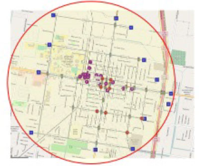
MM. ZONE OF INFLUENCE shall be identified by drawing a border around the outermost intersections/facilities studied in the Traffic Impact Analysis to develop a boundary. If the improvements that generated the original credits are within the Zone of Influence boundary of the development receiving the credit, the credits may be reassigned because the two developments have similar impacts and traffic patterns.
[Codified by Ord. 05-2000, 7/13/00; Amended by Section 2 of Ord. 01-2002, 1/10/02; Amended by Ord. 10-2012, 10/24/12; Amended by Ord. 12-2017, 11/30/17; Amended by Ord. 03-2022, 7/21/22]
11.03.030 Application
A. A TSDC may be imposed upon all New Development within unincorporated Clackamas County for which a Development Permit is required.
B. The applicant for a Development Permit shall, at the time of application, provide the Department with all of the necessary and applicable information, such as the description of use, number of dwelling units or square footage of structures, information about occupancy and size of any existing use on the site, necessary to calculate the TSDC. The Department shall notify the applicant of the right to appeal the decision on the calculation of the charge pursuant to Section 11.03.080.
C. The amount of the TSDC shall be determined as identified in the Methodology and Rate Schedule adopted pursuant to Section 11.03.010(E), and amended pursuant to Section 11.03.030(D), and Section 11.03.090 or adjusted pursuant to Section 11.03.030(F) or 11.03.030(G).
D. If the County has not assigned a TSDC category for the identified land use listed in the adopted Rate Schedule, the Department shall at its option either:
1. Identify the land use category that is most similar to the use in question and apply that rate.
2. Consider trip generation data, gathered in a credible manner, preferably by a registered traffic engineer, for the same or similar use. Such a study shall be prepared at the applicant's expense and must be submitted at least two weeks prior to expected issuance of a Development Permit. The Department Director has the right to accept, accept in part, modify, or reject the calculations offered under this option.
3. The following guidelines apply to data collection under Section 11.03.030(D)(2) for land uses not in the ITE Trip Generation Manual.
a. The applicant shall submit a list of similar uses with similar characteristics in Oregon, Washington, California, or preferably in the Portland region. Uses must have been open for business for at least a year.
b. The Department will determine the number of sites and locations, and if applicable for consolidated land use categories, the types of uses for which the applicant will be required to submit traffic counts.
c. The applicant shall supply the Department with the following information for each site:
i. Monthly adjustment factors to adjust trip generation to the fourth highest business (earnings) month.
ii. Standard days and hours of operations.
iii. Counts from sites on a weekday (mid-week – two day minimum) from 7:00 to 9:00 a.m. and from 4:00 to 6:00 p.m. Actual counting time and days may vary depending on uses and standard days of operation and shall be approved by the Department. Data collection shall be compliant with the ITE Trip Generation Manual.
iv. Quantification of pass by, pedestrian, bicycle and transit trips when applicable.
v. A vicinity map for each site.
d. The applicant shall adjust this data as follows:
i. Adjust a.m. and p.m. trips to Average Weekday Trips based on the proportion of similar uses in the current edition of the ITE Trip Generation Manual.
ii. Adjust daily number to Average Weekday Trips if weekend data are collected.
iii. Adjust Average Weekday Trips to the fourth highest month based on monthly adjustment factors supplied by the applicant.
iv. Adjust pass by, pedestrian, bicycle, and transit trips for potential trip reduction.
e. The Department shall review the applicant's data collection and adjustments, and the Department Director shall issue a final ruling to the applicant regarding which data and adjustments will be used for calculating the TSDC. A fee will be charged for the review of formal alternate trip generation data. The fee will be set by resolution.
E. Any developer requiring the execution of a formal Development Agreement to clarify TSDC assessments, reductions for Station Area Development (Table 1), or reductions for Mixed-Use Development (Table 2) will be required to pay a deposit (as set by Resolution) prior to staff drafting the agreement.
F. Station Area developments reduce vehicle trips on the adjacent roadway. Projects meeting the development density requirements that fall within a Station Area are eligible to receive a reduction that correlates to the reduced impact of the eligible development. An approved Station Area Development is eligible for a reduction on TSDC assessments as outlined in Table 1 (below) when some portion of the development site is located within a 0.25-(one quarter) mile radius (straight line distance measurement) of a light rail station platform or a Bus Transit Corridor route alignment. This reduction may be combined with any applicable Mixed-Use Development reduction (Table 2).
Table 1 – STATION AREA DEVELOPMENT TSDC REDUCTION REQUIREMENTS
| REDUCTION LEVEL | TSDC REDUCTION (% TRANSPORTATION IMPACT REDUCTION) | TRANSIT ACCESS REQUIREMENT (WITHIN 0.25 MILE RADIUS OF:1) | DEVELOPMENT DENSITY REQUIREMENT(S) |
|---|---|---|---|
| Level 1 | 5% Vehicle Trip Reduction | Bus Transit Corridor2 | Minimum residential density of 24 units per acre Minimum FAR of 2.0 per acre for non-residential development |
| Level 2 | 10% Vehicle Trip Reduction | Bus Transit Corridor2 | Minimum res. density of 24 dwellings per acre AND minimum FAR of 2.0 per acre for non-res. development |
| Level 3 | 5% Vehicle Trip Reduction | Light Rail Transit Station3 | Minimum residential density of 12 dwellings per acre4 Minimum FAR of 1.0 per acre for non-res. development |
| Level 4 | 10% Vehicle Trip Reduction | Light Rail Transit Station3 | Minimum Res. Density of 24 dwellings per gross acre |
| Level 5 | 15% Vehicle Trip Reduction | Light Rail Transit Station3 | Minimum Res. Density of 24 dwellings per acre AND at least 15% of the total gross res. & non-res. floor area devoted to commercial/retail uses Minimum FAR of 2.0 per acre for non-res. development |
| Level 6 | 20% Vehicle Trip Reduction | Light Rail Transit Station3 | Minimum res. density of 24 dwellings per acre AND minimum FAR of 2.0 per acre for non-res. development |
1 Some portion of the development site must be located within a 0.25-(one quarter) mile radius (straight line distance measurement) of a Light Rail Station Platform or a Bus Transit Corridor route alignment to qualify for TSDC reduction.
2 Bus Transit Corridors include current fixed-route public bus service (excludes dial-a-ride shuttles and taxi service).
3 Light Rail Transit Station Area is defined as the passenger station platform along a fixed route alignment.
4 The stated residential density for this TSDC reduction level has been interpolated based on ITE Trip Generation Manual results.
Source: ITE, Trip Generation Handbook, 2nd Edition, Appendix B, with noted exception.
G. Mixed-Use developments generate internal trip capture, thus reducing external trip generation rates on surrounding roads. In such event, the Department, for purposes of establishing the TSDC for a Mixed-Use Development, shall apply a Mixed-Use Development TSDC reduction to the eligible structure, or structures, which correlate to the internal trip capture of the proposed development as detailed in Table 2 (below). This reduction may be combined with any applicable Station Area Development reduction (Table 1).
Table 2 - MIXED-USE DEVELOPMENT TSDC REDUCTION REQUIREMENTS
| REDUCTION LEVEL | TSDC REDUCTION (% TRANSPORTATION IMPACT REDUCTION) |
|---|---|
| Level 1 | 7% Vehicle Trip Reduction |
| Level 2 | 10% Vehicle Trip Reduction |
| Level 3 | 14% Vehicle Trip Reduction |
Source: derived using EPA Mixed-Use Trip Generation Model v4.0.
H. If the proposed development includes more than one parcel of land and/or more than one structure, the Mixed-Use Development and/or Station Area reductions shall be authorized as part of a development approval outlining the final build-out of the master plan development area. The applicable reduction shall be memorialized in a Development Agreement (the tool the County will use to secure the developer's compliance with the commitment to build-out a phased master-plan project, qualifying the initial phases for a reduction under the Station Area and/or Mixed-Use reduction provisions) and recorded as a right-to-lien against each parcel included within the approved development area, allowing for renewal on active development projects.
I. If a development avails itself of the Mixed-Use Development and/or Station Area reductions and does not construct the development within the term of the Development Agreement, the County will capture any unwarranted reduction provided by the Department at the time of permitting any built structures based on the original conceptual plan that the final built development does not warrant, by:
1. The Developer paying the TSDC reductions that were attributed to a built structure within the Mixed-Use Development and/or Station Area; or
2. The County collecting the TSDC reductions that were attributed to a built structure within the Mixed-Use Development and/or Station Area by filing a lien against the benefitting parcels.
J. Notwithstanding any other provision, the rates adopted pursuant to 11.03.030(C) shall, annually, be adjusted to account for changes in the costs of acquiring and constructing transportation facilities. The adjustment factor shall be based on the change in the Construction Cost Index.
The Construction Cost Index shall be used by County staff to adjust the TSDC Rate Schedule each fiscal year, unless it is otherwise adjusted by the Board based on adoption of an updated Methodology or TSDC Capital Project List.
[Codified by Ord. 05-2000, 7/13/00; Amended by Section 6 of Ord. 01-2002, 1/10/02; Amended by Ord. 02-2002, 2/28/02; Amended by Ord. 10-2012, 10/25/12; Amended by Ord. 12-2017, 11/30/17]
11.03.040 Collection
A. The TSDC is due and payable at the time of issuance of the Development Permit. The Development Permit shall not be issued, except as provided in Section 11.03.040(C)(3) or 11.03.040(D) of this Section, until payment is made. The TSDC rate in effect at the time that a complete Development Permit or Building Permit, whichever submittal is received last by the County will be applied to that permit.
B. That TSDC rate is effective for 180-days from the date the land use approval is given or the Development Permit is submitted to the Building Department, whichever comes last. At the expiration of the 180-day period, if the permit is not yet issued, any adjustments adopted pursuant to this Ordinance can be applied to the permit.
C. Notwithstanding Section 11.03.030(A), the following are exempt from the TSDC:
1. Guest Homes will not be charged a TSDC assessment because these units share a kitchen and laundry facility with the primary dwelling on the parcel, and as such are not used for boarding, lodging, or rental.
2. Alteration permits for tenant improvements, new construction or remodeling where:
a. no additional dwelling unit(s) or structure(s) are created; or
b. a change of use, building addition, or other modification which does not result in an increase in Average Weekday Trips as determined in the manner set forth in a Methodology adopted pursuant to Section 11.03.010(E), or as provided in Section 11.03.030(D) or 11.03.030(E), whichever is applicable.
3. Relocation of any structure originally located on property that the County acquires in-fee as a part of a capital transportation project that results in a building encroachment over public Right-Of-Way or easements, when the remaining remnant will not be redevelopable, such that the structure is relocated to another parcel within the same system development charge district. Except to the extent such relocation creates additional dwelling units and/or additional Average Weekday Trips as determined in the manner set forth in a Methodology Report adopted by Section 11.03.010(E), or as provided in Section 11.03.030(D) or 11.03.030(E), whichever is applicable.
4. Replacement of any structure located on excess property that the County acquires in-fee as a part of a capital transportation project that can be marketed, or available for occupancy, except to the extent such remodeling or replacement creates additional dwelling units and/or additional Average Weekday Trips as determined in the manner set forth in a Methodology Report adopted by Section 11.03.010(E), or as provided in Section 11.03.030(D) or 11.03.030(E), whichever is applicable, provided:
a. The agency has been provided a reasonable period of time to meet public notification requirements for sale or other disposition (i.e., public auction); and
b. Upon completion of the project, after access has been restored and/or recorded whichever is the later, such that the property has legal ingress/egress for development or occupancy purposes.
D. Payment of the TSDC by a person who is also eligible for a credit voucher for construction of an increased capacity facility may be delayed until a date certain to be set by the Department at the time of development or Building Permit issuance.
Payment may only be delayed for the same development which is associated with the construction of the capital improvement for which credit is given, and the permittee shall provide the Department with security to secure payment of the Charge. The security shall be in an amount determined by the Department, and must be in a form outlined in Section 11.03.040(D)(1), (2) or (3) below, or an alternative method approved by Legal Counsel.
A permittee eligible for delay of payment of the TSDC pursuant to this section shall secure payment of the assessment, prior to issuance of the development or Building Permit, by any of the following:
1. Placing cash in the amount of the assessment in an escrow account accessible by the County. Permittee shall reconcile any remaining balance after applying the credit voucher to the outstanding balance, or revenue in the escrow account shall be withdrawn to cover the balance. Once the balance is reconciled any remaining revenue in the escrow account shall be released, but not later than 180-days after the issuance of the credit voucher against the improvement pursuant to Section 11.03.050.
2. Issuing a letter of credit in the amount of the assessment which is accessible by the County. Permittee shall reconcile any remaining balance after applying the credit voucher to the outstanding balance, or the County shall send a demand to draw down on the letter of credit to cover the balance. Once the balance is reconciled any remaining balance on the letter of credit shall be released, but not later than 180-days after the issuance of the credit voucher against the improvement pursuant to Section 11.03.050.
3. Applying for delay of payment of the TSDC pursuant to ordinance Section 11.03.040(D). Once the credit voucher is issued, the permittee can apply all (or a portion of) the credit voucher toward the principal and interest balance on the account, or continue making installment payments in accordance with the payment plan throughout the duration of the loan. If the installment plan is continued, the applicant would pay an administrative fee at a rate adopted by resolution and interest would begin accruing on the principal balance as of the date of credit voucher issuance.
E. When a TSDC is due and payable, the parcel owner may apply to the County for payment in twenty (20) semiannual installments, secured by a lien on the property upon which the development is to occur, to include interest on the unpaid balance.
1. A parcel owner may request installment payments for up to $500,000 in TSDC assessments; any remaining balance must be paid in full prior to issuance of the Development Permit.
2. The County shall prepare the agreement for installment payments, which shall include a waiver of all rights to contest the validity of the lien, except for the correction of computational errors. The application fee for this option shall be set by resolution.
3. The applicable interest rate shall be determined as follows:
4.
| Principal | Interest Rate |
|---|---|
| $0-24,999 | Current US Federal prime rate plus 3.0 percentage points |
| $25,000-$500,000 | Current US Federal prime rate plus 2.0 percentage points |
5. An applicant requesting installment payments shall have the burden of demonstrating the authority to assent to the imposition of a lien on the property and that the interest of the permittee is adequate to secure payment of the lien. The Department Director may order the imposition of the lien as recommended by the Department.
6. Upon the order of the Department Director, the Department shall cause the lien to be recorded on the lien docket kept by the County Clerk. From that time the County shall have a lien upon the described parcel for the amount of the TSDC, together with interest on the unpaid balance at the rate established by the Department Director. The lien shall be enforceable in the manner provided in ORS Chapter 223, and shall be superior to all other liens pursuant to ORS 223.230. Upon satisfaction of the obligation the Department Director shall request the County Clerk to release the lien.
F. With the passage of Article XI, Section 11 B of the Oregon Constitution, progressive payment shall be taken for all unpaid debt. The Department Director will be notified immediately by the Department of any account thirty (30) days or more past due. The Department Director shall then send a letter to the defaulting party demanding payment no later than thirty (30) days following the date of the demand letter. The demand letter shall require payment of all amounts to bring the account current including any applicable interest or other penalty and shall demand full compliance with a "time is of the essence" clause according to the type of obligation at issue. The time for payment to bring the account current shall be left to the best professional judgment of the Department Director depending upon the type of debt and amount owed but in no event shall time for payment exceed the next payment due date or any other requirements imposed by debt instruments executed by the County in favor of any third party or other agreements that may have been executed by the County.
1. If payment has not been made following the first notice, the County shall send a second notice detailing the prior defaults and notices thereof indicating that further action, including legal action, will be taken.
2. Unless payment is received in the time period designated in the second notice, the County may proceed with any action in law or equity to enforce its rights and collect the debt, and that upon such failure the entire amount outstanding shall immediately become due and payable.
[Codified by Ord. 05-2000, 7/13/00; Amended by Ord. 01-2002, 1/10/02; Amended by Ord. 02-2002, 2/28/02; Amended by Ord. 05-2003, 3/13/03; Amended by Ord. 10-2012, 10/25/12; Amended by Ord. 12-2017, 11/30/17]
11.03.050 Credit
An applicant for a Development Permit, shall be entitled to a credit against the TSDC for payment of a fee-in-lieu of construction or for the construction of a Qualified Public Improvement. Calculation of any TSDC credit value will be based on this Ordinance and the Methodology in place as of the date the County receives a complete TSDC credit application. The applicant shall have the burden of demonstrating in its application for credit that a particular improvement qualifies for credit.
A. The County shall provide credit for the documented, reasonable cost of construction (whether paid via fee-in-lieu of or a constructed improvement) of all or part of a Qualified Public Improvement listed in TSDC Capital Project List, adopted pursuant to 11.03.010(E), based on the following criteria:
1. Transportation improvements located neither on nor contiguous to the property that is the subject of development approval shall be considered for credit at 100% of the cost of the qualified improvements.
2. Transportation improvements located on or contiguous to the property that is the subject of development approval, and required to be built larger, or with greater capacity than is necessary for the particular development project shall be considered for credit. Credit for these improvements may be granted only for the cost of that portion of the improvement that exceeds the capacity needed to serve the particular development project or property.
3. Developers are constructing Qualified Public Improvements in lieu of the County capital projects group. In accordance with County Code Section 7.03.099(B), utility relocations to accommodate these road designs should be performed at no cost to the developer.
4. No more than 13.5 percent of the total qualifying construction cost shall be creditable for survey, engineering, and inspection.
5. No credits shall be granted for Oregon Department of Transportation (ODOT) facilities unless clearly identified as a Qualified Public Improvement listed in the TSDC Capital Project List.
6. Road Right-Of-Way dedicated pursuant to the applicable development conditions shall be considered for credit as follows:
a. Road Right-Of-Way located neither on nor contiguous to the property that is the subject of development approval shall receive credit for the dedication.
b. Road Right-Of-Way located on or contiguous to the property that is the subject of development approval, and required to be built larger, or with greater capacity than is necessary for the particular development project shall be considered for credit to the extent necessary to construct the facility in excess of the capacity needed to serve the particular development project or property.
c. Credit for right of way shall be allowed based on:
i. Reasonable market value of land purchased by the applicant from a third party and necessary to complete the improvement; or
ii. A certified market appraisal, paid for by the applicant, that establishes the land value when the property was donated for the needed right of way; or
iii. A per square foot value using the then current real market value for the real property shown in the records of the County Tax Assessor.
B. All requests for credit vouchers must be in writing and filed with the Department not more than ninety days after acceptance of the improvement. Improvement acceptance shall be in accordance with the practices, procedures and standards of the Department.
C. The amount of any credit shall be determined by the Department and based upon the actual cost incurred by the applicant to construct the improvement, as supported by contract documents, and other appropriate information, provided by the applicant for the credit. In the request, the applicant must identify the improvement(s) for which credit is sought and explain how the improvement(s) meet the requirements of this section.
D. The applicant shall also document, with credible evidence, the value of the improvement(s) for which credit is sought. If, in the Department's opinion, the improvement(s) meets the requirements of this section and the Department concurs with the proposed value of the improvement(s), a credit shall be granted for the eligible amount.
E. The value of the credits under this Section shall be determined by the Department based on the actual cost of construction and Right- Of- Way, as applicable, as verified by receipts and other credible evidence submitted by the applicant. Upon a finding by the Department that the contract amounts, including payments for Right-Of-Way, exceed prevailing market rates for a similar project, the credit shall be based upon market rates.
F. The Department shall respond to the applicant's request in writing within 45 days of receipt of a complete request. The Department shall provide a written explanation of the decision on the credit request.
G. Upon approval, the Department shall provide the applicant with a credit voucher signed by the Department Director, on a form provided by the Department. The credit voucher shall state a dollar amount that may be applied against any TSDC imposed against the subject property. In no event shall a subject property be entitled to redeem credit vouchers in excess of the TSDC imposed on the subject property, except as provided for in Section 11.03.050(J).
H. A credit shall have no cash or monetary value and a remaining balance on a voucher shall not be a basis for any refund. A credit shall only apply against the TSDC and its only value is to be used to reduce the TSDC otherwise due, subject to all conditions, limitations, and requirements of this chapter.
I. When issued by the Department, a credit shall be the personal property of the applicant. Applicant may transfer all or part of any earned credit to one or more Affiliates of the applicant. Credits shall remain the personal property of the applicant, unless transferred by the applicant or its authorized agent as transferor. Any person claiming the right to redeem a credit shall have the burden of demonstrating ownership of the credit.
J. Prior to permit issuance, upon written application to the Department, a credit shall be applied to the TSDC on a permit for development on a lot or parcel within the confines of the property originally eligible for the credit. In the case of multi-phase development, excess credit generated in one phase may be applied to reduce the TSDC in subsequent phases of the original development project.
K. Credits may be reassigned from the applicant to another individual or entity for use on another property if all the following conditions are met.
1. A request for Assignment of a credit voucher must be made in writing with a notarized letter to the Department signed by the person who owns the credit. The request for Assignment of a credit voucher shall contain all the information necessary to establish that such an Assignment is allowable under this subsection. The burden of proof that an Assignment is allowable is on the applicant. The Department shall respond in writing to the applicant's request for Assignment within 30 days of receipt of the request.
2. Credits may be Assigned if the Department determines that either:
a. The lot or parcel that is to receive the credit is adjacent to and served by the transportation improvements that generated the credits, or
b. The transportation improvements that generated the original credits are located within the Zone of Influence of the Department traffic impact analysis for the development receiving the credit.
3. When a credit voucher or portion of a credit voucher is Assigned, a notarized Assignment of Transportation SDC Credits notice shall be sent from the Department to both parties clarifying the Assignment. The amount Assigned shall be deducted from the transferor's credit voucher balance and Assigned to the transferee.
a. The Assignment shall reference the original credit voucher number, which is associated with the property to which the initial credit was issued.
b. The Assignment shall have the same expiration date as the initial credit voucher.
c. The credit shall be applied to the TSDC on a permit for development on a lot or parcel within the confines of the property eligible for Assignment as described in subsection 11.03.050(I) of this section.
4. An Assigned credit voucher shall follow all rules regarding redemption of credits.
5. The Department may charge a fee, as set by resolution, for administering the Assignment of credits.
L. Any credit must be redeemed not later than the issuance of the Development Permit. The applicant is responsible for presentation of any credit prior to issuance of the Development Permit. Except as provided in Section 11.03.060, under no circumstances shall any credit redemption be considered after issuance of a Development Permit.
M. Credit vouchers shall expire on the date ten years after the acceptance of the applicable improvement. No extension of this deadline shall be granted.
N. The Department Director can delegate signature authority for credit vouchers to a designee.
[Codified by Ord. 05-2000, 7/13/00; Amended by Ord. 01-2002, 1/10/02; Amended by Ord. 10-2012, 10/25/12; Amended by Ord. 12-2017, 11/30/17]
11.03.060 Refunds
A. Refunds may be given by the County upon finding that there was a clerical error in the calculation of the TSDC. Refunds shall not be allowed for failure to claim credit, as provided for in Section 11.03.050, at the time of Development Permit issuance. The refund must be requested within six (6) months of the date the assessment was paid; failure to avail oneself of this grace period forfeits any future right to receive a refund and the value of the TSDC paid will remain with the parcel for future development.
B. A fee (set by Resolution) will be charged on any refund of an assessment paid on development that did not commence. The fee may be paid in cash or the applicant can opt to reduce the amount of the refund to cover the cost of the fee.
[Codified by Ord. 05-2000, 7/13/00; Amended by Ord. 01-2002, 1/10/02; Amended by Ord. 10-2012, 10/25/12; Amended by Ord. 12-2017, 11/30/17]
11.03.070 Dedicated Funds, Project Lists
A. All monies derived from the TSDC shall be placed in the County TSDC Fund. TSDC revenue shall be used to fund those projects identified in the TSDC Capital Project List adopted pursuant to Section 11.03.010(E), and costs related to compliance with the provisions of this ordinance, as provided by ORS 223.307.
B. The TSDC shall not be expended for costs associated with the construction of administrative office facilities that are more than an incidental part of other capital improvements.
C. The TSDC shall not be expended for costs of the operation or routine maintenance of capital improvements.
D. The TSDC Capital Project List adopted pursuant to Section 11.03.010(E) may be amended from time to time by Board Resolution. If the Rate Schedule will be increased by a proposed modification of the TSDC Capital Project List to include capacity increasing capital improvement cost(s):
1. The County shall provide, at least 30 days prior to the adoption of the modification, notice of the proposed modification to the persons who have requested written notice under ORS 223.305(6).
2. If the County receives a written request for a hearing on the proposed modification within seven days of the date the proposed modification is scheduled for adoption, the County shall hold a public hearing.
3. Notwithstanding ORS 294.160, a public hearing is not required if the County does not receive a written request for a hearing.
4. The decision of the County to increase the Rate Schedule by modifying the list may be judicially reviewed only as provided in ORS 34.010 to 34.100.
[Codified by Ord. 05-2000, 7/13/00; Amended by Section 15 of Ord. 01-2002, enacted 1-10-02; Amended by Section 5 of Ord. 02-2002, 2-28-02; Amended by Ord. 10-2012, 10/25/12; Amended by Ord. 12-2017, 11/30/17]
11.03.080 Appeal
A. A person challenging the expenditure of TSDC revenues may appeal the expenditure to the Board by filing a written request with the Department Director. An appeal of an expenditure must be filed within two years of the date of the alleged improper expenditure.
After providing notice to the appellant, the Board shall determine whether the expenditure is in accordance with this ordinance and the provisions of ORS 223.297 to 223.314. If the Board determines that there has been an improper expenditure of TSDC revenues, the Board shall direct that a sum equal to the misspent amount shall be deposited within one year to the credit of the account or fund from which it was spent.
B. Appeals of any other decision required or permitted to be made by the Department under this ordinance must be filed with the Hearings Officer by filing a written request and paying the appeals fee with the Department within fourteen (14) days of the Department's decision, or payment of the assessment, whichever comes first. The individual acting as the Hearings Officer will be appointed by the Board.
a. After providing notice to the appellant, the Hearings Officer shall determine whether the Department's decision is in accordance with this ordinance and the provisions of ORS 223.297 to 223.314 and may affirm, modify, or overrule the decisions.
b. The fee for formally appealing a decision to the Hearings Officer will be set by resolution.
C. The decision of the Hearings Officer shall be reviewable solely under ORS 34.010 through 34.100. The person who has appealed a decision shall be notified of this right to review of the decision.
D. A legal action challenging the Methodology adopted by the Board pursuant to Section 11.03.010(E) shall not be filed later than 60 days after adoption. A person shall contest the Methodology used for calculating a TSDC only as provided in ORS 34.010 to ORS 34.100.
[Codified by Ord. 05-2000, 7/13/00; Amended by Section 16 of Ord. 01-2002, 1/10/02; Amended by Ord. 05-2003, 3/13/03; Amended by Ord. 10-2012, 10/25/12; Amended by Ord. 12-2017, 11/30/17]
11.03.090 Annual Review
Prior to January 1 of each year the County shall provide an annual accounting for the activity occurring in the dedicated funds created by 11.03.070 for the previous fiscal year. The accounting shall show by fund the total amount of system development charges collected, the amount spent on each project that was funded in whole or in part in that fiscal year, and the amount attributed to the costs of complying with the provisions of ORS 223.297 to 223.314.
[Codified by Ord. 05-2000, 7/13/00; Amended by Section 17 of Ord. 01-2002, 1-10-02; Amended by Ord. 10-2012, 10/25/12; Amended by Ord. 12-2017, 11/30/17]