ACCESSORY BUILDING OR USE: A subordinate building or use, the function of which is clearly incidental to that of the main building or use on the same lot.
ACCESSWAY: A public right-of-way, a portion of which is hard surfaced, for use by pedestrians and bicyclists providing a direct route where public roads require significant out of direction travel.
ACCESS DRIVE: A private way created by deed or easement to provide vehicular ingress to, or egress from two lots or parcels.
ACTIVE RECREATIONAL AREA: An area such as a park, sports field, or golf course, where turf lawn provides a playing surface that is dedicated to active play.
ADJOINING: Contiguous or abutting exclusive of street width. It shall include the terms adjacent, abutting or contiguous.
AIRPORT, PERSONAL-USE: An airstrip restricted, except for aircraft emergencies, to use by the owner and, on an infrequent and occasional basis, by his invited guests, and to commercial activities in connection with agricultural operations only.
AIRPORT, PRIVATE USE: An airport restricted, except for aircraft emergencies, to use by the owner and his invited guests. The determination as to whether an airport is private or public-use is made by the Oregon Department of Aviation.
AIRPORT, PUBLIC-USE: An airport that is open to use by the flying public, with or without a request to use the airport.
ALLEY: A travel way that is used primarily for vehicular service access to the back or side of properties otherwise abutting on a street.
ALTERATION, CULTURAL RESOURCE: Any exterior change or modification, through public or private action, of any cultural resource or of any property located within an historic district including, but not limited to, exterior changes to or modification of structure, architectural details or visual characteristics such as paint color and surface texture, grading, surface paving, new structures, cutting or removal of trees and other natural features, disturbance of archaeological sites or areas, and the placement or removal of any exterior objects such as signs, plaques, light fixtures, street furniture, walls, fences, steps, plantings and landscape accessories affecting the exterior visual qualities of the property.
ANTIQUES: Goods that, by virtue of their age or unusual quality, are generally considered to be of historical and/or artistic interest, ordinarily such items are in good state of preservation or are restorable to their original conditions.
AQUIFER: A layer of rock or alluvial deposit which holds water.
ARCHITECTURAL FEATURES: Features include, but are not limited to cornices, canopies, sunshades, gutters, chimneys, fireplaces, flues and eaves. Architectural features shall not include any portion of a structure built for the support, occupancy, shelter or enclosure of persons or property of any kind.
ARCHITECTURAL FEATURES, CULTURAL RESOURCE: The architectural elements embodying style, design, general arrangement and components of all of the outer surfaces of an improvement, including, but not limited to, the kind, color, texture of the building materials and type and style of all windows, doors, lights, signs and other fixtures appurtenant to such improvements.
AUTOMATIC IRRIGATION CONTROLLER: An automatic timing device used to remotely control valves that operate an irrigation system. Automatic irrigation controllers schedule irrigation events using either evapotranspiration (weather-based) or soil moisture sensor data.
BABYSITTER: A person who goes into the home of a child to give care during the temporary absence of the parent or legal guardian or custodian.
BASEMENT: A portion of a building which has less than one-half of its height measured from finished floor to finished ceiling above the average elevation of the adjoining ground, but not an "underground structure" as defined in this ordinance.
BEACON: Any light with one or more beams directed into the atmosphere or directed at one or more points not on the same site as the light source; also, any light with one or more beams that rotate or move.
BED AND BREAKFAST HOMESTAY: A use that is conducted in an owner-occupied single-family dwelling, provides rooms for rent on a daily or weekly basis to the public, and includes breakfast as part of the cost of the room. A maximum of two guest rooms and a maximum of five guests at one time are permitted.
BED AND BREAKFAST INN: A use that is conducted in an operator- or owner-occupied single-family dwelling, provides rooms for rent on a daily or weekly basis to the public, and includes breakfast as part of the cost of the room. A bed and breakfast inn may include a restaurant offering meals to the general public as well as to overnight guests.
BED AND BREAKFAST RESIDENCE: A use that is conducted in an operator- or owner-occupied single-family dwelling, provides rooms for rent on a daily or weekly basis to the public, and includes breakfast as part of the cost of the room. In addition to the required breakfast, other occasional family-style meals may be provided for overnight guests.
BICYCLE RACK: An apparatus designed to support the central frame of a bicycle and allow locking of both wheels, without the removal of wheels.
BIKEWAY: A paved facility provided for use by cyclists. There are five types of bikeways.
- Shared Roadway: A type of bikeway where motorists and cyclists occupy the same roadway area. Shared roadways are allowed on neighborhood streets and on rural roads and highways.
- Shoulder Bikeway: A bikeway which accommodates cyclists on paved roadway shoulder.
- Bike Lane: A section of roadway designated for exclusive bicycle use, at the same grade as the adjacent roadway.
- Bike Path: A bike lane constructed entirely separate from the roadway.
- Cycle Track: An exclusive "grade-separated" bike facility elevated above the street level using a low-profile curb and a distinctive pavement material.
BLANKETING: The visual blocking of one sign by another as seen by a motorist traveling a street or highway.
BLOCK: A parcel of land bounded by streets, railroad rights-of-way, waterways, parks, unsubdivided acreage, or a combination thereof.
BOUNDARY LINE: A separation that delineates the confines of a property for development purposes, such as from another property, or from an easement granted for right-of-way or private motor vehicle access.
BUILDING: Any structure used or intended for supporting or sheltering any use or occupancy.
BUILDING ENVELOPE: The three dimensional space which is to be occupied by a building.
BUILDING LINE: A straight line that is parallel and adjacent to the plane of the primary building façade (exclusive of architectural features, arcades, bay or bow windows, porches, patios, stairs, or ramps) that is most close to parallel to the front lot line. A lot with more than one front lot line will have multiple building lines. If a property has more than one primary building, the building line is established based on the façade plane of the primary building nearest to the front lot line.
BUILDING OR STRUCTURE HEIGHT: The term "height of building" shall be calculated by the methods identified in the State of Oregon Structural Specialty Code or the State of Oregon One and the Two Family Dwelling Specialty Code, as applicable.
CANNABINOID: Any of the chemical compounds that are the active constituents of marijuana.
CANNABINOID CONCENTRATE: A substance obtained by separating cannabinoids from marijuana by a mechanical extraction process; a chemical extraction process using a nonhydrocarbon-based or other solvent, such as water, vegetable glycerin, vegetable oils, animal fats, isopropyl alcohol, or ethanol; a chemical extraction process using the solvent carbon dioxide, provided that the process does not involve the use of high heat or pressure; or any other process identified by the Oregon Liquor and Cannabis Commission, in consultation with the Oregon Health Authority, by rule.
CANNABINOID EDIBLE: Food or potable liquid into which a cannabinoid concentrate, cannabinoid extract, or dried marijuana leaves or flowers have been incorporated.
CANNABINOID EXTRACT: A substance obtained by separating cannabinoids from marijuana by a chemical extraction process using a hydrocarbon-based solvent, such as butane, hexane or propane; a chemical extraction process using the solvent carbon dioxide, if the process uses high heat or pressure; or any other process identified by the Oregon Liquor and Cannabis Commission, in consultation with the Oregon Health Authority, by rule.
CANNABINOID PRODUCT: A cannabinoid edible and any other product intended for human consumption or use, including a product intended to be applied to the skin or hair, that contains cannabinoids or dried marijuana leaves or flowers. Cannabinoid product includes usable marijuana, cannabinoid extracts, or cannabinoid concentrates that have been combined with an added substance; or any combination of usable marijuana, cannabinoid extracts, or cannabinoid concentrates. Cannabinoid product does not include usable marijuana by itself, a cannabinoid concentrate by itself, a cannabinoid extract by itself, or industrial hemp as defined in ORS 571.269.
CARE: The provision of room and board and other services as needed to assist in activities of daily living, such as assistance with bathing, grooming, eating, medication management, money management, or recreation.
CHILD CARE CENTER: As defined in ORS 329A.244(1)(a). Includes child care facility, excluding family child care home; preschool or school-age recorded program; and parent cooperative, as defined in ORS 329A.250.
CHILD CARE FACILITY: As defined in ORS 329A.250.
CLACKAMAS REGIONAL CENTER: The regional center identified on Comprehensive Plan Map 10-CRC-1, Regional Center, Corridors, and Station Community, excluding the portion in the City of Happy Valley.
CLACKAMAS REGIONAL CENTER AREA: The Clackamas Regional Center Area identified on Comprehensive Plan Map 10-CRC-1, Regional Center, Corridors, and Station Community, excluding the portion in the City of Happy Valley.
COGENERATION FACILITY: A facility that produces, through the sequential use of energy, electric energy and useful thermal energy including but not limited to heat or steam, used for industrial, commercial, heating, or cooling purposes; and is more than 50 percent owned by a person who is not an electric utility, an electric holding company, an affiliated interest, or any combination thereof.
COMMERCIAL USE: The use of land and/or structures for the conduct of retail, service, office, artisan, restaurant, lodging, entertainment, private recreational, professional, and similar uses.
COMMON OWNERSHIP: Land commonly owned to include open space lands dedicated in planned unit developments and lands dedicated for open space which are owned by homeowners associations.
COMMUNITY GARDEN: A site where any kind of plant, except marijuana, is grown, and several individuals or households cultivate the site. The site may be divided into individual allotments, or gardeners may work together to cultivate the entire property. The land may be publicly or privately owned. The plants are grown for personal use by the gardeners, or for donation, and sales are prohibited.
COMPOSTING: The managed process of controlled biological decomposition of green feedstocks. It does not include composting for the purposes of soil remediation.
COMPOSTING FACILITY: A site or facility, excluding home composting and agricultural composting conducted as a farm use, which utilizes green feedstocks to produce a useful product through a managed process of controlled biological decomposition. Composting may include amendments beneficial to the composting process. Vermiculture and vermicomposting are considered composting facilities.
CONGREGATE HOUSING FACILITY: A building that contains more than one dwelling unit and provides common facilities and services for residents who require or desire a more supportive living environment than typically afforded to residents in other types of dwellings. Regular on-premise supervision by a registered physician, registered nurse, or other health care provider may be included.
COTTAGE CLUSTER: A group of four or more detached dwelling units with a common courtyard, all of which are located on the same lot of record or on middle housing lots.
COTTAGE CLUSTER DEVELOPMENT: A development site with one or more cottage clusters.
CULTURAL RESOURCE: Improvements, buildings, structures, signs, features, sites, places, areas or other objects of scientific, aesthetic, educational, cultural, architectural, or historical significance to the community members of the county.
CULTURAL RESOURCE INVENTORY: The official list of designated cultural features, sites, districts subject to the provisions of Section 707, Historic Landmark (HL), Historic District (HD), and Historic Corridor (HC).
CULTURAL RESOURCES OBJECT: A material thing of functional, aesthetic, cultural, symbolic or scientific value, usually by design or nature movable.
DEDICATION: The designation of land by its owner for any general or public use.
DESIGNATED SITE (historic site, cultural resource site, landmark site): A parcel or part thereof on which a cultural resource is situated, and any abutting parcel or part thereof constituting part of the premises on which the cultural resource is situated, and which has been designated pursuant to this Ordinance.
DESIGNATED STRUCTURE (landmark, cultural resource, historic structure): Any improvement that has special historical, cultural, aesthetic or architectural character, interest or value as part of the development, heritage or history of the county, the State of Oregon, or the nation and that has been designated pursuant to this ordinance.
DIMENSIONAL STANDARD: A numerical measurement for a distance or area standard of this Ordinance, such as building height, lot size, or setback; or a percentage of a distance or area measurement of this Ordinance, such as lot coverage or landscaped area.
DIRECT ROUTE: The shortest reasonable route between two points. A route is considered direct if it does not involve significant out of direction travel that could be avoided. Out of direction travel is significant if it is more than 50 percent longer than the straight line between two points.
DISTINCTIVE URBAN FOREST: Forested or woodland areas which are visually prominent or contain unique or rare tree and plant communities. These areas are usually found in association with other open space resources within the urban area.
DRIP LINE, TREE: The outermost edge of a tree's canopy; when delineating the tree drip line on the ground, it will appear as an irregularly shaped circle defining the canopy's perimeter.
DRIVE AISLE: A drive aisle is the portion of a motor vehicle parking area provided for the purpose of ingress and egress to individual parking spaces within the parking area. A drive aisle is different from an internal or private street in that an internal or private street does not provide direct access to parking spaces, except for parallel spaces.
DRIVEWAY: The area of a property that is located between a road and a motor vehicle parking area. A driveway includes the location of any apron or motor vehicle entrance onto the lot but does not include any parking spaces, internal streets, or private streets provided as a part of the motor vehicle parking area. A driveway may also contain or be crossed by walkways provided for pedestrians.
DROUGHT-TOLERANT PLANTS: Plants that will survive in the typical or somewhat less than typical amount of rainfall in the Willamette Valley, and therefore require very little or no supplemental water once established.
DUPLEX: A building that contains exactly two dwelling units, both of which are located on the same lot of record or on middle housing lots. If one of the two dwelling units is an accessory dwelling unit, the building is not a duplex.
DWELLING: A building that contains one or more dwelling units. A dwelling may be a residential trailer or a manufactured dwelling but not a recreational vehicle, except when the recreational vehicle is approved as a temporary dwelling pursuant to Section 1204, Temporary Permits, or as a second dwelling pursuant to Section 847, Recreational Vehicles as Second Dwellings.
DWELLING, ACCESSORY HISTORIC: A detached single-family dwelling legally constructed between 1850 and 1945 that was converted from a primary dwelling to an accessory dwelling, pursuant to Section 843, Accessory Historic Dwellings.
DWELLING, DETACHED SINGLE-FAMILY: A building that contains only one dwelling unit and is detached from any other dwelling, except where otherwise permitted for an accessory dwelling unit. A manufactured dwelling, residential trailer, or dwelling unit in a cottage cluster is not a detached single-family dwelling.
DWELLING, MULTIFAMILY: A building that contains five or more dwelling units.
DWELLING UNIT: A building, or portion thereof, with one or more rooms designed for residential occupancy by one family.
EASEMENT: A right of usage of real property granted by an owner to the public or to specific persons, firms, and corporations.
EDIBLE GARDEN: A garden that contains plants that produce food for human consumption.
ELECTRIC VEHICLE CHARGING STATION: A location where a vehicle can plug into an electrical source to re-charge its batteries.
EQUINE FACILITY: Premises that are used for the stabling or training of equines, including, but not limited to, providing riding lessons, training clinics, and schooling shows.
FAMILY: Any individual or group of persons, regardless of relationship but not exceeding 15 persons, living together as a single housekeeping unit within a dwelling unit.
FAMILY CHILD CARE HOME: A child care facility that provides child care to 16 or fewer children, including children of the provider, regardless of full-time or part-time status, in the home of the provider. Child and child care are as defined in ORS 329A.250.
FARMERS' MARKET: An organized seasonal outdoor market dedicated to the direct sales by growers of agricultural goods, including plants, produce, meats, and other animal products (e.g., eggs, cheese, honey), but excluding marijuana.
FLAG: Any fabric, banner, or bunting containing distinctive colors, patterns, or symbols.
FLOOR AREA: The area inside the perimeter walls of a building or portion thereof. For a building, or portion thereof, not provided with perimeter walls, the floor area shall be the area under the horizontal projection of the roof or floor above. Floor area shall not include exterior stairs, exterior covered entries, or portions of buildings used for parking of vehicles. In a multi-story building, floor area is the sum of the floor area of each floor. For the purposes of calculating floor area, mezzanines and lofts are considered to be floors within perimeter walls.
FLOOR AREA RATIO (FAR): A measurement of density expressed as the ratio of floor area (in square feet) to net site area (in square feet). The greater the ratio, the greater the density. For example, a building occupying one-fourth of the net site area has a FAR of 0.25:1, or 0.25; adding a second floor of equal area to the same building increases the FAR to 0.5:1, or 0.5.
GOVERNMENT CAMP: The unincorporated community of Government Camp, as identified on Comprehensive Plan Map 10-MH-4, Government Camp Village Plan, Land Use Plan & Boundary.
GRADE: The line of the street or ground surface deviation from the horizontal.
GREEN FEEDSTOCKS: Yard debris, non-treated wood waste, vegetative food waste, produce waste, vegetative restaurant waste, vegetative food processor by-products, crop waste, and livestock manure. Non-treated wood waste excludes wood waste treated with paint, varnish, or other chemicals or preservatives.
GREEN ROOF: A vegetated roof designed to treat storm runoff.
GROUNDWATER: Any water, except capillary moisture, beneath the land surface or beneath the bed of any stream, lake, reservoir, or other body of surface water, whatever may be the geological formation or structure in which such water stands, flows, percolates, or otherwise moves.
GUEST HOUSE: An accessory building, or portion thereof, that includes at least one bedroom and is—with the exception of bathrooms, closets, and halls—constructed as habitable space under the Oregon Residential Specialty Code.
HARDSCAPES: In the practice of landscaping, refers to the inanimate, manmade, non-planted, outdoor areas where the soil is no longer exposed and that are surfaced with pervious or non-pervious durable materials such as masonry, wood, stone, paving, tile, or similar material to create patios, walkways, water fountains, benches, gazebos, etc.
HAZARDOUS SUBSTANCE, MATERIAL, OR WASTE: Any hazardous substance, material, or waste listed in the following federal regulations:
1. Superfund Amendments and Reauthorization Act (SARA) of 1986, Section 302 Extremely Hazardous Substances List (40 C.F.R 355, App. A and B);
2. Comprehensive Environmental Response Compensation & Liability Act Superfund (CERCLA) of 1980, Hazardous Substances List (40 C.F.R 302, Table 302.4);
3. SARA of 1986, Section 313, Toxic Chemicals List (40 C.F.R Section 372.65);
4. Resource Conservation and Recovery Act (RCRA) of 1976 and 1984 Amendments, Hazardous Wastes List (P & U Categories) (40 C.F.R Section 261.33(e) and (f)); and
5. DOT Hazardous Materials Table (49 C.F.R Part 172.101).
HISTORIC AREA: Any area containing improvements which have a special character, historical interest or aesthetic value or which represent one or more architectural periods or styles typical of the history of the County and which improvements constitute a distinct section of the County that has been designated a cultural resource district pursuant to this ordinance.
HOME COMPOSTING: A composting area operated and controlled by the owner or person in control of a single-family dwelling and used to dispose of vegetative waste, garden wastes, weeds, lawn cuttings, leaves, and prunings generated from that property.
HOME OCCUPATION: An occupation or business activity that results in a product or service and is conducted, in whole or in part, in a dwelling unit, an accessory building normally associated with primary uses allowed in the subject zoning district, or both. Home occupations do not include garage sales, yard sales, holiday bazaars, or home parties which are held for the purpose of the sale or distribution of goods or services unless such sales and parties are held more than six times in a calendar year or operate in excess of 24 total days in a calendar year.
HOMEOWNERS ASSOCIATION: The grouping or uniting of persons residing within a defined area, such as a subdivision, into an incorporated entity for the prosecution of a common enterprise.
HOSPITAL, ANIMAL: A building or premises for the medical or surgical treatment of domestic animals or pets, including dog, cat, and veterinary hospitals.
HOTEL: A building which is designed or used to offer short-term lodging for compensation, with or without meals, for six or more people. A facility that is operated for the purpose of providing care beyond that of room and board is not a "hotel".
HOUSEKEEPING UNIT: A living arrangement within a dwelling unit in which the kitchen, living and dining rooms, and other general living areas of the dwelling unit are shared in common, and the duties, rights, and obligations associated with the performance of domestic tasks and management of household affairs, are shared by the residents by virtue of legal relationship or mutual agreement. Such a living arrangement also may include the provision of food, shelter, personal services, care, and when appropriate, a planned treatment or training program of counseling, therapy, or other rehabilitative social service, for persons of similar or compatible conditions or circumstances who are members of the resident family.
HYDROELECTRIC FACILITY: Any facility relating to the production of electricity by waterpower, including, but not limited to the power generating plant, associated dams, diversions, penstocks, navigation locks, fish ladders, fish screens, reservoirs and detention areas, recreation facilities, substations, access roads, offices or commercial and industrial structures proposed to be built in connection with the energy facility; and activities involved in their construction and operation.
IMPROVEMENT: Any building structure, parking facility, fence, gate, wall, work of art or other object constituting a physical betterment of real property, or any part of such betterment.
INDIRECT ILLUMINATION: A nonelectric sign illuminated by an indirect or separate light source.
INDUSTRIAL USE: The use of land and/or structures for the manufacturing or processing of primary, secondary, or recycled materials into a product; warehousing and associated trucking operations; wholesale trade; and related development.
INSTITUTIONAL USE: The use of land and/or structures for activities such as child care centers, adult daycare and pre-school facilities, public and private schools, colleges, universities, art, music, trade and other educational and training facilities, convalescent care facilities, nursing homes, hospitals, places of worship, fraternal lodges, municipal and civic buildings, transit centers and park-and-ride facilities, parks, swimming pools and other recreational facilities open to the public or a membership group, senior and community centers, libraries, museums, cemeteries and mausoleums, utility facilities, and similar public and private uses.
INVASIVE NON-NATIVE OR NOXIOUS VEGETATION: Plant species that are listed in the Oregon Department of Agriculture's Noxious Weed Policy and Classification System.
KENNEL: Any lot or premises on which four or more dogs, more than six months of age or with permanent canine teeth, are kept for purposes other than a veterinary clinic.
KIOSK: A small structure used as a newsstand, information booth, refreshment stand, bandstand, or display of goods, etc.
KITCHEN, ACCESSORY: A kitchen that complies with all of the following standards:
1. It shall be incidental to a primary dwelling.
2. It shall be located in a room that is approved for residential occupancy and used for a purpose in addition to that of a kitchen (e.g., a recreation room, a bedroom).
3. It shall not be located in a detached accessory building.
4. Any of the following features shall be located within a contiguous area that is no more than 30 inches deep and 10 feet long: cooking appliances, sinks, refrigerators, dishwashers, counters, and cabinets.
LANDSCAPING: Areas of land planted with groundcover, grasses, shrubs, annuals, perennials, or trees.
LIMITED USE: A use allowed in a district on a limited basis and subject to conditions specified therein which are generally more restrictive than the conditions placed on primary or accessory uses within the same district.
LIVESTOCK: One or more domesticated animals raised to produce commodities, such as food, fiber, and labor. Livestock includes, but is not limited to, miniature livestock, fowl, and farmed fish.
LOT: A single unit of land that is created by a subdivision of land. For the purposes of this Ordinance, lot includes parcel and lot of record unless otherwise specified in the context of the specific provisions.
LOT AREA OR LOT SIZE: The total surface area (measured horizontally) within the lot lines of a lot. For property with a Comprehensive Plan designation of Rural, Agriculture, or Forest, lots with street frontage on County or public road rights-of-way may include the land area between the front lot line and the centerline of the County or public road rights-of-way. This allowance does not apply to land area within a state or federal highway right-of-way.
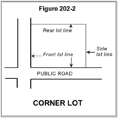
LOT, CORNER: A lot with more than one front lot line, where at least two front lot lines intersect. A lot within the radius curve or curves of a single street is not a corner lot and the collective boundary line or lines that separate the lot from the adjacent street shall be viewed as one lot line. A lot may be both a corner lot and a through lot.
LOT COVERAGE: The area of a lot covered by a building or buildings, exclusive of architectural features and swimming pools, expressed as a percentage of the total lot area.
LOT DEPTH: The mean horizontal distance between the front lot line and the rear lot line of a lot.
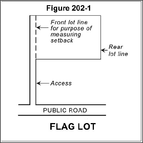
LOT, FLAG: A lot that has access to a road by means of a strip of lot or easement no greater than 25 feet in width.
LOT LINE, FRONT: Any boundary line separating a lot from a County, public, state, or private road, or from an access drive or a private street. Exceptions are:
1. Except as otherwise provided in Subsection 903.08, the front lot line of a flag lot shall be within the boundaries of the lot by a distance equal to the width of the narrow strip of lot or easement providing access to the lot. The front lot line shall be parallel to the lot line extending from the road to the lot line opposite and most distant from the road. (See Figure 202-1.)
2. A corner lot may have more than one front lot line. Each lot line established by a County or public road is a front lot line. Each lot line established by a private road or access drive from which motor vehicle access is taken is a front lot line. Unless the lot is a through lot, all other lot lines that would be front lot lines are side lot lines if those lines separate the lot from a private road or access drive
3. A through lot has at least two front lot lines except where one of the lot lines that would otherwise be a front lot line abuts a collector, arterial, expressway, interstate, or other feature that precludes motor vehicle access. In that case, the lot line where access is precluded is the rear lot line.
4. Any portion of a boundary line that separates a lot from an area of a private road or access drive may be a side lot line if:
a. The boundary line delineates an area outside of the primary travel or parking areas of the private road or access drive;
b. This area is provided for the maneuvering of emergency vehicles as required by the Roadway Standards, Comprehensive Plan, or this Ordinance;
c. No motor vehicle access serving the lot makes use of the emergency vehicle maneuvering area; and
d. Any garage or carport motor vehicle entry oriented towards the boundary line complies with the minimum front setback applicable to such entries.
LOT LINE, REAR: The whole length of any boundary line opposite and most distant from the front lot line and not intersecting a front lot line. Exceptions are:
1. For a corner lot, the rear lot line is any one of the boundary lines opposite the front lot lines. Any other opposite boundary line is a side lot line. (See Figure 202-2.)
2. A triangular-shaped lot has no rear lot line. A triangular-shaped lot is one whose lot lines only intersect at three points.
3. A through lot has no rear lot line except where one of the lot lines that would otherwise be a front lot line abuts a collector, arterial, expressway, interstate, or other feature that precludes motor vehicle access. In that case, the lot line where access is precluded is a rear lot line.
LOT LINE, SIDE: Any boundary line that is not a front or rear lot line.
LOT OF RECORD:
1. A lot or parcel created by a subdivision or partition plat, as defined in ORS chapter 92, filed with the Clackamas County Surveyor and recorded with the Clackamas County Clerk;
2. A unit of land created by a recorded deed or recorded land sales contract and in compliance with all applicable planning, zoning, and subdivision or partition ordinances and regulations, if any, in effect on the date the deed or land sales contract was signed by the parties to the deed or contract; or
3. A unit of land created solely to establish a separate tax account or for mortgage purposes; that did not conform to all planning, zoning, or subdivision or partition ordinances or regulations in effect on the date it was created; and that was sold prior to September 5, 2023, under the foreclosure provisions of ORS chapter 88.
LOT, THROUGH: A lot that has street frontage on two or more non-intersecting streets. A lot may be both a corner lot and a through lot.
LOT WIDTH: The mean horizontal distance between the side lot lines of a lot.
LOT, ZONING: A "zoning lot or lots" is a single tract of land located within a single block, which (at the time of filing for a building permit) is designated by its owner or developer as a tract to be used, developed, or built upon as a unit under single ownership or control. Therefore, a "zoning lot or lots" may or may not coincide with a lot of record.
LOW VOLUME IRRIGATION: The application of irrigation water at low pressure through a system of tubing or lateral lines and low-volume emitters such as drip, drip lines, and bubblers. Low volume irrigation systems are specifically designed to apply small volumes of water slowly at or near the root zone of plants.
MAJOR TRANSIT STOP: A transit center, major bus stop, or light rail stop, as identified on Comprehensive Plan Map 5-8a, Transit, Urban.
MAJOR TRANSIT STREET: A street with a Frequent Service Bus Line, as identified on Comprehensive Plan Map 5-8a, Transit, Urban; existing or planned High Capacity Transit, as identified on Comprehensive Plan Map 5-8c, High Capacity Transit (HCT) System Plan; or both.
MANUFACTURED DWELLING: A mobile home or manufactured home but not a residential trailer or recreational vehicle.
MANUFACTURED DWELLING PARK: Any place where four or more manufactured dwellings or prefabricated structures that are relocatable and more than eight and one-half feet wide, are located within 500 feet of one another on a lot, tract, or parcel of land under the same ownership, the primary purpose of which is to rent or lease space or keep space for rent or lease to any person for a charge or fee paid or to be paid for rental or lease or use of facilities or to offer space free in connection with securing the trade or patronage of such person. Manufactured dwelling park does not include a lot or lots located within a subdivision being rented or leased for occupancy by no more than one manufactured dwelling per lot.
MANUFACTURED HOME: A structure constructed on or after June 15, 1976, for movement on the public highways that has sleeping, cooking, and plumbing facilities, that is intended for human occupancy by one family, that is being used for residential purposes, and that was constructed in accordance with federal manufactured housing construction and safety standards and regulations in effect at the time of construction.
MARIJUANA: The plant Cannabis family Cannabaceae, any part of the plant Cannabis family Cannabaceae, and the seeds of the plant Cannabis family Cannabaceae. Marijuana does not include industrial hemp as defined in ORS 571.269 or prescription drugs, as that term is defined in ORS 689.005, including those containing one or more cannabinoids, that are approved by the United States Food and Drug Administration and dispensed by a pharmacy, as defined in ORS 689.005.
MARIJUANA ITEMS: Marijuana, cannabinoid products, cannabinoid concentrates, and cannabinoid extracts.
MARIJUANA PROCESSING: The processing, compounding, or conversion of marijuana into cannabinoid products, cannabinoid concentrates, or cannabinoid extracts, provided that the marijuana processor is licensed by the Oregon Liquor and Cannabis Commission (OLCC), a holder of a research certificate issued by the OLCC, or registered with the Oregon Health Authority.
MARIJUANA PRODUCTION: The manufacture, planting, propagation, cultivation, growing, or harvesting of marijuana, provided that the marijuana producer is licensed by the Oregon Liquor and Cannabis Commission (OLCC), a holder of a research certificate issued by the OLCC, or registered with the Oregon Health Authority and a "person designated to produce marijuana by a registry identification cardholder." Marijuana production does not include the drying of marijuana by a marijuana processor if the marijuana processor is not otherwise producing marijuana; or the cultivation and growing of an immature marijuana plant by a marijuana wholesaler or marijuana retailer if the marijuana wholesaler or marijuana retailer purchased or otherwise received the plant from a licensed marijuana producer.
MARIJUANA RETAILING: The sale of marijuana items to a consumer, provided that the marijuana retailer is licensed by the Oregon Liquor and Cannabis Commission or registered with the Oregon Health Authority.
MARIJUANA WHOLESALING: The purchase of marijuana items for resale to a person other than a consumer, provided that the marijuana wholesaler is licensed by the Oregon Liquor and Cannabis Commission.
MASTER PLAN: A sketch or other presentation showing the ultimate development layout of a parcel of property that is to be developed in successive stages or subdivisions. The plan need not be completely engineered but shall be of sufficient detail to illustrate the property's inherent features and probable development pattern.
MIDDLE HOUSING: A duplex, triplex, quadplex, townhouse, or cottage cluster.
MIDDLE HOUSING LAND DIVISION: A partition or subdivision of a lot of record that is developed, or proposed to be developed, with more than one middle housing dwelling unit. The type of middle housing developed on the original lot of record is not altered by a middle housing land division. Notwithstanding the definition of partition or subdivision, within the same calendar year as an original partition that was not a middle housing land division, the County may allow one or more of the resulting vacant parcels to be further partitioned into not more than three parcels through a middle housing land division.
MIDDLE HOUSING LOT: A lot or parcel created through a middle housing land division. A middle housing lot is a separate lot of record; however, development on a middle housing lot is limited by conditions imposed at the time of the middle housing land division. Middle housing lots are not divisible.
MILL SITE, ABANDONED OR DIMINISHED: A mill, plant, or other facility engaged in the processing or manufacturing of wood products, including sawmills and facilities for the production of plywood, veneer, hardboard, panel products, pulp, and paper, that is located outside of urban growth boundaries; was closed after January 1, 1980, or has been operating at less than 25 percent of capacity since January 1, 2003; and contains or contained permanent buildings used in the production or manufacturing of wood products.
MIXED-USE: A mix of uses located within a single building, such as retail on the first floor and residential or office uses on the upper floors.
MOBILE HOME: A structure constructed for movement on the public highways that has sleeping, cooking, and plumbing facilities, that is intended for human occupancy by one family, that is being used for residential purposes, and that was constructed between January 1, 1962, and June 15, 1976, and met the construction requirements of Oregon mobile home law in effect at the time of construction.
MOBILE VENDING UNIT: A vehicle that is used in selling and dispensing goods or services to the customer. Notwithstanding this definition, a mobile vending unit shall not be used in selling and dispensing marijuana items. As used in this definition, a vehicle is motorized or non-motorized transportation equipment containing an axle and intended for use on public roads, including, but not limited to, a car, van, pickup, motorcycle, recreational vehicle, bus, truck, detached trailer, or a truck tractor with no more than one trailer.
MOTEL: A building or series of buildings in which lodging only is offered for compensation and which may have more than five sleeping rooms or units for this purpose and which is distinguished from a hotel primarily by reason of providing direct independent access to and adjoining parking for each rental unit designed primarily for automobile tourists and transient persons. The term includes auto courts, tourist courts, tourist homes, and motor lodges.
NATIVE PLANTS: Any indigenous or resident species currently or historically found in the Willamette Valley.
NATURAL AREA: An area of land or water that has substantially retained its character and functions as an important habitat for plant and animal life.
NONCONFORMING DEVELOPMENT: An element of development, such as landscaping, parking, height, signage, or setbacks that was created in conformance with development regulations which, due to a change in the zone or zoning regulations, is no longer in conformance with the current applicable regulations.
NONCONFORMING USE: A use of any building, structure or land allowed by right when established or that obtained a required land use approval when established but, due to a change in the zone or zoning regulations, is now prohibited in the zone.
NURSERY: The propagation of trees, shrubs, vines or flowering plants for transplanting, sale, or for grafting or budding; planting of seeds or cuttings; grafting and budding one variety on another; spraying and dusting of plants to control insects and diseases, and buying and selling the above plant stock at wholesale or retail. Help and seasonal labor may be employed. The term "nursery" contemplates the sale of a product of such nursery. The conduct of a nursery business presumes parking places for customers, the keeping of sales records, and quarters for these functions. However, the use does not include the business of reselling goods purchased off the premises, except plant stock, or the establishment of a roadside stand.
NURSING HOME: A nursing, convalescent, or rest home facility licensed by the State under ORS chapters 441 and 442, or an assisting living facility licensed under ORS 443, which provides, for a period exceeding 24 hours, the continuous services of licensed nursing personnel to care for chronically ill or infirm patients, exclusive of those patients related to the owner or facility administrator by blood or marriage. Such nursing, convalescent, or rest home must provide nursing services to those patients who, in the judgment of a physician, registered nurse, or facility administrator, require remedial, restorative, supportive, or preventive nursing measures.
OAR: Oregon Administrative Rules
OPEN SPACE: Land within a development which has been dedicated in common to the ownership within the development or to the public specifically for the purpose of providing places for recreational uses or for scenic purposes. Open space shall be used as such in perpetuity.
ORS: Oregon Revised Statutes
OVERBURDEN: Earth that lies above a natural deposit of a mineral.
OVERHEAD SPRINKLER IRRIGATION: The application of irrigation water from spray heads, rotors, or other above-ground emitters that send water through the air.
OWNER: Person or persons holding fee title to a parcel, lot or tract of land, except in those instances when the land is being sold on contract, the contract purchaser shall be deemed the owner.
PARCEL: A single unit of land that is created by a partition of land. For the purposes of this Ordinance, parcel includes lot and lot of record unless otherwise specified in the context of the specific provisions.
PARKING AREA, MOTOR VEHICLE: A defined portion of a property provided for the parking and maneuvering of motor vehicles. A parking area may be located within an easement and shared between multiple lots without being considered a private road or access drive for the purpose of assigning lot lines.
A motor vehicle parking area may contain drive aisles but does not have additional driveways providing access to further lots or parking areas – see "road, private," "access drive," "street, internal," and "street, private" where this is the case.
PARKING STRUCTURE: A building having at least two levels that are designed and used for parking vehicles, or a building having one level of covered parking area under an open space or recreational use. A one-level surface parking area, garage, or carport is not a parking structure.
PARTITION: To divide an area or tract of land into two or three parcels within a calendar year when such area or tract of land exists as a unit or contiguous units of land under single ownership at the beginning of such year. "Partition" does not include divisions of land resulting from lien foreclosures, divisions of land resulting from foreclosure of recorded contracts for the sale of real property and divisions of land resulting from the creation of cemetery lots; and "partition" does not include any adjustment of a lot line by the relocation of a common boundary where an additional parcel is not created. "Partition" does not include the sale of a lot in a recorded subdivision, even though the lot may have been acquired prior to the sale with other contiguous lots or property by a single owner.
PEDESTRIAN AMENITIES: Outdoor improvements directly visible and accessible to pedestrians that promote and facilitate pedestrian use, including plazas, pocket parks, courtyards, awnings or other weather protection, kiosks, gazebos, water features, drinking fountains, sculpture, outside seating areas, planters, trellises, and street furniture.
PEDESTRIAN PATHWAY: A hard-surfaced or permeable hard-surfaced pedestrian facility adjacent to a public roadway where there is no curb, but is protected from vehicular traffic or set back behind a planting strip.
PEDESTRIAN-SCALE LIGHTING: Street lights designed to illuminate sidewalks to provide security for nighttime use by pedestrians. Pedestrian scale lighting includes ornamental lighting with a 14- to 25-foot mounting height and which meets the Illumination Society guidelines for Commercial Collector roadways.
PENNANT: Any lightweight plastic, fabric, or other material, whether or not containing a message of any kind, suspended, usually in series, from a rope, wire, or string, and designed to move in the wind.
PERSON DESIGNATED TO PRODUCE MARIJUANA BY A REGISTRY IDENTIFICATION CARDHOLDER: A person designated to produce marijuana by a registry identification cardholder under ORS 475C.792 who produces marijuana for a registry identification cardholder at an address other than the address where the registry identification cardholder resides or at an address where more than 12 mature marijuana plants are produced.
PERVIOUS: Any surface or material that allows the passage of water through the material and into the underlying soil.
PLAT, FINAL: A final map and other writing containing all the descriptions, locations, specifications, dedications, provisions, and information concerning a partition or subdivision and recorded as required by ORS Chapter 92.
PLAT, PRELIMINARY: A clearly legible and approximate drawing of the proposed layout of streets, blocks, lots and other elements of a subdivision or partition which shall help furnish a basis for the approval or disapproval of the general layout of a partition or subdivision. As used in this Ordinance, preliminary plat shall be synonymous with tentative plan as used in ORS Chapter 92.
POROUS PAVEMENT: Surface to walk, drive or park on that may reduce stormwater runoff by allowing water to soak into the ground. Examples are permeable pavers, pervious concrete, porous asphalt, and gravel.
PREFABRICATED STRUCTURE: A building or subassembly that has been in whole or substantial part manufactured or assembled using closed construction at an off-site location to be wholly or partially assembled on-site; is relocatable; is more than eight and one-half feet wide; and is designed for use as a single-family dwelling. A prefabricated structure is not a manufactured dwelling or "small home", as defined in ORS Chapter 455.
PREMISES: A lot, building, or portion of a lot or building, occupied by a use with its appurtenances.
PRESERVATION, CULTURAL RESOURCES: The identification, study, protection, restoration, rehabilitation or enhancement of cultural resources.
PRIMARY BUILDING WALL: Exterior building wall which contains a public entrance to the occupant's premises and faces either a street or a parking area.
PRODUCE STAND: A table, bench, cart, or structure, any of which may be covered, that is located or erected for the purpose of direct sales by growers of agricultural goods, including vegetables, fruits, flowers, bulbs, herbs, plants, honey, and similar products, but not including marijuana or processed foods such as jams or jellies, that are produced on the same tract on which the produce stand is located.
PROFESSIONAL SERVICES: Activities such as those offered by a physician, surgeon, dentist, lawyer, architect, engineer, accountant, artist, teacher, real estate agent, and insurance agent.
PROPERTY LINE ADJUSTMENT: A relocation or elimination of all or a portion of the common property line between two abutting lots of record that does not create an additional lot of record. As used in this definition, a property line is the entirety of the boundary line between two abutting lots of record.
PUBLIC OWNERSHIP: Land owned by federal, state, regional, or local government, or governmental agency.
PUBLIC WATER SYSTEM: A system for the provision to the public of piped water for human consumption, if such system has more than three service connections and is a facility licensed by the State of Oregon Health Division.
QUADPLEX: A building that contains exactly four dwelling units, all of which are located on the same lot of record or on middle housing lots.
RAINWATER COLLECTION SYSTEM: A system of pipes, container (rain barrel, rainwater tank, pond, or rainwater reservoir), valves and associated apparatus for collecting and storing harvested rainwater runoff, typically from rooftops via rain gutters, but also from ground catchment systems.
RECREATIONAL VEHICLE: A vehicle licensed by the State of Oregon, with or without motive power, that is designed for human occupancy and to be used temporarily for recreational, seasonal, or emergency purposes, and has a gross floor area not exceeding 400 square feet in the set-up mode. These shall include but are not limited to park trailers, travel trailers, pickup campers, motor homes, fifth wheel trailers, camping and tent trailers.
RECYCLABLE DROP-OFF SITE: A convenient location not within a public right-of-way where mobile depots or drop boxes may be sited as a recyclable material collection point for nearby residents prior to delivery to a broker or user of such materials.
RECYCLE/RECYCLING: A process by which solid waste materials are transformed into new products in such a manner that the original products may lose their identity. It shall also include the collection, transportation, or storage of products by other than the original user or consumer, giving rise to the product's being in the stream of commerce for collection, disposal, recycling, reuse, resource recovery, or utilization.
RECYCLING CENTER: A facility that primarily purchases for recycling or reuse principal recyclable materials which have been source-separated by type, such as vegetative yard debris, paper, glass, and metal, by the person who last used the unseparated solid wastes, but not a salvage or junkyard. Principal recyclable materials are those items defined as such by the Oregon Department of Environmental Quality.
RELATIVE: A parent, child, brother, sister, grandparent, or grandchild of a person or person's spouse.
REPLAT: The act, other than a property line adjustment or a middle housing land division, of platting the lots, parcels, tracts, or easements in a final plat to achieve a reconfiguration of the existing final plat or to increase or decrease the number of lots or parcels.
RESERVE STRIP: A strip of land, usually one foot in width, across the end of a street or alley which shall be under the ownership of the County to insure street extensions where needed.
RESIDENTIAL TRAILER: A structure constructed for movement on the public highways that has sleeping, cooking, and plumbing facilities, that is intended for human occupancy by one family, that is being used for residential purposes, and that was constructed before January 1, 1962.
RESIDENTIAL TREATMENT FACILITY: A facility that provides, for six or more individuals with mental, emotional or behavioral disturbances or alcohol or drug dependence, residential care and treatment in one or more buildings on contiguous properties. For the purposes of a residential treatment facility or residential treatment home, "treatment" means the systematic, planned maintenance, development or enhancement of self-care skills, social skills or independent living skills, or the planned sequence of systematic interactions, activities or structured learning situations designed to meet each resident's specified needs in the areas of physical, social, emotional and intellectual growth.
RESIDENTIAL TREATMENT HOME: A facility that provides for five or fewer individuals with mental, emotional or behavioral disturbances or alcohol or drug dependence, residential care and treatment in one or more buildings on contiguous properties.
RESOURCE RECOVERY FACILITY: Any facility at which solid waste is processed for the purpose of extracting, converting to energy, or otherwise separating and preparing solid waste for reuse, but not a salvage or junkyard.
RHODODENDRON: The unincorporated community of Rhododendron, as identified on Comprehensive Plan Map 4-7, Non-Urban Area Land Use Plan, Mt. Hood Corridor Land Use Plan.
RIGHT-OF-WAY: The legal right, established by usage or grant, to pass through property owned by another, or the strip of land subject to a nonowner's right to pass through.
ROAD: A public or private way created to provide ingress to, or egress from, one or more lots, parcels, areas or tracts of land, or that provides for travel between places by vehicles. A private way created exclusively to provide ingress and egress to land in conjunction with a forest, farm or mining use is not a "road". The terms "street," "access drive," and "highway" for the purposes of this Ordinance shall be synonymous with the term "road," except "street, internal" and "street, private" shall have the meanings provided elsewhere in this Ordinance.
ROAD, COUNTY: A public way under County jurisdiction which has been accepted into the County road maintenance system by order of the Board of County Commissioners.
ROAD, PRIVATE: A private way created by deed or easement to provide vehicular ingress to, or egress from, three or more lots or parcels. When a private way is located integrally within a motor vehicle parking area, refer to "street, internal" and "street, private."
ROAD, PUBLIC: A public way dedicated or deeded for public use but not accepted into the County road maintenance system, intended primarily for vehicular circulation and access to abutting properties.
ROADWAY: That portion of a road or alley that has been improved for vehicular and pedestrian traffic.
SALVAGE: Separating, collecting, or retrieving reusable solid waste for resale.
SALVAGE, JUNKYARD: A location at which solid wastes are separated, collected, and/or stored pending resale.
SCHOOL, COMMERCIAL: A building where instruction is given to pupils in arts, crafts, or trades, and operated as a commercial enterprise as distinguished from schools endowed or supported by taxation.
SENSITIVE GROUNDWATER AREA: Any area classified by the State of Oregon as a groundwater limited area, critical groundwater area, or other area where new groundwater appropriations are restricted by the State of Oregon.
SERVICE STATION: A commercial establishment with sales and services limited to the sale of motor fuels and supplying goods and service generally required in the operation and maintenance of automotive vehicles and fulfilling a motorist's needs. These may include sale of petroleum products; sale and servicing of tires, batteries, automotive accessories and replacement items; washing and lubricating services; the performance of minor automotive maintenance and repair, and the supplying of other incidental customer services and products. Major automotive repairs, painting and fender work are excluded. An electric vehicle charging station is not a service station.
SETBACK: The shortest horizontal distance between a structure and the lot line.
SETBACK, FRONT: The shortest horizontal distance between a structure and the front lot line.
SETBACK, REAR: The shortest horizontal distance between a structure and the rear lot line.
SETBACK, SIDE: The shortest horizontal distance between a structure and the side lot line.
SHARED PARKING: Parking spaces used jointly by two or more uses within the same development, or separate adjacent developments, which either have peak hours of operation that do not overlap, or typically provide services to many of the same patrons (e.g., restaurant in an office complex or hotel providing lodging for convention participants within the same development), provided satisfactory legal evidence is presented in the form of deeds, leases, or contracts securing full access to such parking spaces for all parties jointly using them.
SHORT-TERM RENTAL: The rental of a dwelling unit, portion of a dwelling unit, or guest house for overnight residential purposes, for a period of up to 30 consecutive nights. Overnight occupancy of the dwelling unit plus any guest house shall not exceed 15 persons. A short-term rental may include use of accessory structures, such as decks or swimming pools, that are located on the same lot as the dwelling unit or guest house being rented.
SIDEWALK: A concrete pedestrian facility adjacent to a curb along a road or set back from the curb behind a planting strip.
SIGN: A presentation or representation, other than a house number, by words, letters, figures, designs, pictures or colors displayed out of doors in view of the general public so as to give notice relative to a person, a business, an article of merchandise, a service, an assemblage, a solicitation, or a request for aid or other type of identification. This definition specifically includes billboards, ground signs, freestanding signs, wall signs, roof signs, logo signs, and signs on the following: marquees, awnings, canopies, street clocks and furniture and includes the surface upon which the presentation or representation is displayed.
SIGN, ANIMATED: Any sign that uses movement or change of lighting to depict action or create a special effect or scene.
SIGN AREA, OR SURFACE AREA: The area, on the largest single face of a sign, within a perimeter which forms the outside shape of a sign. If the sign consists of more than one module, the total area of all modules will constitute the sign area. The area of a sign having no such perimeter or border shall be computed by enclosing the entire copy area within the outline of either a parallelogram, triangle, circle or any other easily recognized geometric shape and then computing the area. Where a sign is of a three-dimensional, round or irregular shape, the largest cross section shall be used in flat projection for the purpose of computing sign area.
SIGN, BUILDING: Any sign attached to any part of a building, as contrasted to a freestanding sign.
SIGN, CHANGEABLE COPY: A sign or portion thereof with characters, letters, or illustrations that can be changed or rearranged without altering the face or the surface of the sign. A sign on which the message changes more than eight times per day shall be considered an animated sign and not a changeable copy sign for purposes of this ordinance.
SIGN, COMMERCIAL: Any sign associated with a commercial activity.
SIGN, DIRECTORY: An onsite sign that identifies and directs traffic to a number of tenants, uses, or buildings within a development.
SIGN, DRIVE-THRU: A freestanding or building sign for a commercial drive-thru window service that is oriented toward a drive-thru lane on the same property and that is for viewing by drivers and their passengers while they are in the drive-thru lane, but does not extend higher than eight feet above grade.
SIGN, ELECTRONIC MESSAGE CENTER: A sign, display, or device, or portion thereof, whose message may be changed by electronic process or remote control, and includes electronic time and temperature displays and the device known in the advertising industry as a commercial electronic variable message sign.
SIGN, FREESTANDING: A sign not attached to a building.
SIGN, INCIDENTAL: A sign, generally informational, that has a purpose secondary to the use of the site on which it is located, such as "no parking," entrance," "loading only," "telephone," and other similar directives.
SIGN, INTEGRAL ROOF: Any sign erected or constructed as an integral or essentially integral part of a normal roof structure of any design, such that no part of the sign extends vertically above the highest portion of the roof and such that no part of the sign is separated from the rest of the roof by a space of more than six inches.
SIGN, LOGO: A sign consisting of a trademark or symbol.
SIGN, MESSAGE: Anything displayed on an electronic message center sign, including copy and graphics.
SIGN, MONUMENT: A sign which extends from the ground or which has a support which places the bottom thereof less than two feet from the ground.
SIGN, OFF-PREMISES: A sign which advertises goods, products or services which are not sold, manufactured, or distributed on or from the premises or facilities on which the sign is located.
SIGN, POLE: A sign erected and maintained on a freestanding frame, mast or pole and not attached to any building but does not include ground-mounted signs.
SIGN, PORTABLE: Any sign not permanently attached to the ground or other permanent structure, and/or designed to be transported, including, but not limited to, signs designed to be transported by means of wheels; signs converted to A- or T-frames; menu and sandwich board signs; balloons used as signs; umbrellas used for advertising; and signs attached to or painted on vehicles parked and visible from the public right-of-way, unless said vehicle is used as other than a sign in the normal day-to-day operations of the business for transportation of goods and/or personnel.
SIGN, PROJECTING: Any sign affixed to a building or wall in such a manner that its leading edge extends more than six inches beyond the surface of such building or wall.
SIGN, PUBLIC SERVICE INFORMATION: Any sign, or message on an electronic message center sign, which provides the time, date, temperature, weather, or information concerning civic, charitable or other noncommercial activities.
SIGN, RESIDENTIAL: Any sign associated with a dwelling.
SIGN, ROOF: Any sign erected and constructed wholly on and on top of the roof of a building, supported by the roof structure.
SIGN, SEGMENTED MESSAGE: Any message or distinct subunit of a message presented by means of at least one display change on an electronic message center sign.
SIGN, TEMPORARY: Any sign that is normally considered to be of temporary duration and is not permanently mounted. Examples include, but are not limited to: commercial signs for limited term events, election signs, real estate signs, etc.
SIGN, TRAVELING MESSAGE: A message which appears to move across an electronic message center sign.
SIGN, WALL: Any sign parallel to, and attached within six inches of a wall, painted on the wall surface, or erected and confined within the limits of an outside wall of any building or structure, which is supported by such wall or building, and which displays only one sign surface.
SIGN, WINDOW: Any sign, pictures, symbol, or combination thereof, that is placed inside a window or upon the window panes or glass and is visible from the exterior of the window.
SIGNIFICANT NATURAL AREAS: Natural areas as defined in "Oregon National Areas - Clackamas County Data Summary" published by The Nature Conservancy. This list of natural areas may be amended by the County as additional areas are identified.
SINGLE ROOM OCCUPANCY: A residential development with no fewer than four attached units that are independently rented and lockable and provide living and sleeping space for the exclusive use of an occupant, but require that the occupant share sanitary or food preparation facilities with other units in the occupancy.
SNOW SLIDE AREA: The area around a building that may be subject to snow buildup as a result of snow sliding from the sloped roof of the building.
SOIL MOISTURE SENSOR: A device that measures the amount of water in the soil. The device also suspends and initiates irrigation events.
SOLAR ENERGY SYSTEM: Any solar collector, or other solar energy device, the primary purpose of which is to provide for the collection, storage, and distribution of solar energy for space heating or cooling, water heating, or electricity.
1. The power generating capacity of a roof-mounted solar energy system that is located on a primary use, conditional use, or limited use structure is limited only by the size of the system that can fit within the confines of the roof surface to which it is mounted.
2. The power generating capacity of a ground-mounted solar energy system, or of a roof-mounted solar energy system that is located on an accessory structure, is limited to power consumed by the development to which the system is accessory, or—if the system feeds power into the grid of a public utility company—to an amount equivalent to no more than the annual usage of the development to which the system is accessory.
SOLID WASTE: As defined in Chapter 10.03, Solid Waste and Wastes Management, of the Clackamas County Code.
STORMWATER MANAGEMENT FACILITY: Any facility that is designed, constructed, and maintained to collect, treat, filter, retain, or detain surface water runoff during and after a storm event for the purpose of controlling flows or reducing pollutants in stormwater runoff. Stormwater management facilities include, but are not limited to, constructed wetlands, rain gardens, water quality swales, stormwater planters, infiltration facilities, and ponds.
STORY: A portion of a building included between a floor and the ceiling next above it, exclusive of a basement.
STREAM: A body of perennial running water, together with the channel occupied by such running water.
STREAM CORRIDOR AREA: An area including the streambed and a required strip or buffer of land on each side of the streambed necessary to maintain streamside amenities and existing water quality. The width of the stream corridor area varies with the site conditions and shall be determined by on-the-ground investigation, as provided under Subsection 1002.04(B). The intent of the stream corridor area shall be to preserve natural environmental qualities and the function of land to purify water before it reaches the stream but not to prohibit timber management activities pursuant to the State Forest Practices Act.
STREET FRONTAGE: The entire linear distance of a lot abutting a street. Toe strips or flair strips shall not be used to satisfy the minimum street frontage requirements of the Ordinance.
STREET: See "ROAD", except that "street, internal" and "street, private" shall have the definitions provided elsewhere in this Ordinance.
STREET, INTERNAL: A way located outside of a road that is provided for motor vehicle circulation within a commercial, industrial, institutional, or mixed-use development or between multiple such developments. An internal street may also be located within a residential development that consists of housing other than detached single family dwelling(s), temporary dwelling(s), accessory dwelling units, or middle housing.
STREET, PRIVATE: An internal street that has been improved with curbs, sidewalks or pedestrian paths, street trees, and pedestrian-scale lighting.
STREET FURNITURE: Any structural element other than residential, industrial or commercial buildings, streets, sidewalks and curbs shall be considered street furniture including, but not limited to, benches, bus shelters, newsstands, bulletin boards, kiosks, drinking fountains, bicycle stalls, etc.
STRUCTURE: Anything constructed or erected, which requires location on the ground or attached to something having a location on the ground.
SUBDIVIDE: To divide an area or tract of land into four or more lots within a calendar year when such area or tract exists as a unit or contiguous units, under a single ownership at the beginning of such year, whether or not that area or tract of land is divided by a water course or a road right-of-way.
SUBDIVISION: A division of property creating four or more lots in the same calendar year.
SUBDIVISION, MAJOR: A subdivision creating 11 or more lots in the same calendar year.
SUBDIVISION, MINOR: A subdivision creating four to 10 lots in the same calendar year.
SUNNYSIDE VILLAGE: The Sunnyside Village community plan area, as identified on Comprehensive Plan Map 10-SV-1, Sunnyside Village Plan, Land Use Plan Map.
SURFACE MINING: Includes the mining of minerals by removing overburden and extracting a natural mineral deposit thereby exposed, or simply such extraction. Surface mining includes open-pit mining, auger mining, production of surface mining waste, prospecting and exploring that extracts minerals or affects land, processing to include rock crushing and batch plant operations, and excavation of adjacent offsite borrow pits other than those excavated for building access roads. Surface mining does not mean operations within a road right-of-way or other easement for the purpose of construction, reconstruction, or maintenance; excavations of sand, gravel, clay, rock, or other similar materials by a landowner or tenant for the purpose of construction, reconstruction, or maintenance of access roads; excavation or grading in the process of farming, forestry, or cemetery operations, or other onsite construction, unless more than 5,000 cubic yards of such materials are removed from the property for compensation, except that more than 5,000 cubic yards of such materials may be removed from the property for compensation when the construction activities are authorized by a building permit.
SURFACE MINING, MINERALS: Soil, clay, stone, sand, gravel, and any other inorganic solid excavated from a natural deposit in the earth for commercial, industrial, or construction use.
SURFACE MINING, NONAGGREGATE MINERALS: Coal and metal-bearing ores, including, but not limited to, ores that contain nickel, cobalt, lead, zinc, gold, molybdenum, uranium, silver, aluminum, chrome, copper, or mercury.
SURFACE MINING, OPERATOR: A legal entity engaged in surface mining or in an activity at a surface mining site preliminary to surface mining.
SURFACE MINING, RECLAMATION: Procedures designed to minimize the disturbance from surface mining and to provide for the rehabilitation of surface resources through the use of plant cover, soil stabilization, and other procedures to protect the surface and subsurface water resources, and other measures appropriate to the subsequent beneficial use of mined lands.
SURFACE WATER MANAGEMENT REGULATORY AUTHORITY: The surface water management district in which the subject property is located, or, if there is no such district, the County.
TOWNHOUSE: A dwelling unit that shares at least one wall, or portion thereof, with another townhouse and is located on a separate lot of record from any other dwelling that is not an accessory dwelling unit.
TRACT: One or more contiguous lots of record under the same ownership. Notwithstanding the preceding definition, as used in Sections 706, Habitat Conservation Area District, 709, Water Quality Resource Area District, 1012, Lot Size and Density, 1013, Planned Unit Developments, and 1105, Subdivisions, Partitions, Replats, Condominium Plats, and Vacations of Recorded Plats, a tract is a unit of land (other than a lot or parcel) created by a subdivision, partition, or replat.
TRAIL: A hard- or soft-surfaced facility for pedestrians, bicyclists, or equestrians that is separate from vehicular traffic. Trails often go through natural areas and are designed to have a minimal impact on the natural environment.
TRANSFER STATION: A fixed or mobile facility used as part of a solid waste collection and disposal system or resource recovery system, between a collection route and a processing facility or a disposal site, including, but not limited to, drop boxes made available for general public use. Solid waste collection vehicles are not transfer stations.
TRANSIT STOP: Any posted bus or light rail stop.
TRIPLEX: A building that contains exactly three dwelling units, all of which are located on the same lot of record or on middle housing lots.
TURF LAWN: A ground-cover surface made up of thick, closely mowed, cultivated grass.
UNDERGROUND STRUCTURE: A structure in which more than 50 percent of the cubic footage of the enclosed, covered space is (1) constructed below the highest elevation of the ground adjoining the structure site prior to excavation; and (2) covered over by ground materials, such as soil, sod, sand or exterior paving, which are continuous on at least one side of the structure with contiguous surface ground materials. Conventional roofing materials may be used to cover any portion of the structure which extends above ground elevation.
UNINCORPORATED COMMUNITY: A settlement that conforms to the definition set forth in OAR chapter 660, division 22. The County's unincorporated communities are identified in Chapter 4 of the Comprehensive Plan and shown on Map 4-7 of the Comprehensive Plan.
USE: The purpose for which land or a building is arranged, designed or intended, or for which either land or a building is or may be occupied.
UTILITY CABINET: A small enclosure used to house utility equipment intended for off-site service, such as electrical transformer boxes, telephone cable boxes, cable television boxes, fire alarm boxes, police call boxes, traffic signal control boxes, and other similar apparatus.
UTILITY FACILITY: A building, structure, or any constructed portion of a system that provides for the production, transmission, conveyance, delivery, or furnishing of heat, light, power, gas, water, sanitary sewer, stormwater, telephone, cable television, internet, or other similar service. Utility facility does not include wireless telecommunication facility.
UTILITY LINE: A utility facility consisting of a cable, conduit, pipe, wire, drainageway, or other linear conveyance system. A utility line may include support poles, support towers, and equipment for the monitoring or operation of the utility line, provided that such equipment is mounted on the poles or towers; underground; or both aboveground and not exceeding five feet in length, width, and height.
UTILITY SERVICE LINE: A utility line that ends at the point where the utility service is received by the customer. A service line is distinguished from larger utility lines including, but not limited to, distribution lines, mainlines, transmission lines, and trunk lines.
VEHICLE, COMMERCIAL: A commercially licensed and operated vehicle exceeding the capacity of one ton.
VISUALLY SENSITIVE AREAS: Prominent natural landscape features such as hillsides, forests, and waterways; historic district; visual corridors along major highways and rivers. Natural landscapes that occur within the urban area and along traffic corridors are of higher visual significance.
WALKWAY: A hard-surfaced facility for pedestrians, within a development or between developments, distinct from surfaces used by motor vehicles. A walkway is distinguished from a sidewalk by its location on private property.
WELL, EXEMPT-USE: A well from which groundwater is used as defined in ORS 537.545(1) as amended.
WELL, PERMITTED: A well from which the intended use of water requires a registration, certificate of registration, application for a permit, permit, certificate of completion, or groundwater right certificate under ORS 537.505 to 537.795 and 537.992.
WEMME/WELCHES: The unincorporated community of Wemme/Welches, as identified on Comprehensive Plan Map 4-7, Non-Urban Area Land Use Plan, Mt. Hood Corridor Land Use Plan.
WETLANDS: Areas that are inundated or saturated by surface or ground water at a frequency and duration sufficient to support, and that under normal circumstances do support, a prevalence of vegetation typically adapted for life in saturated soil conditions.
WILDWOOD/TIMBERLINE: The unincorporated community of Wildwood/Timberline, as identified on Comprehensive Plan Map 4-7, Non-Urban Area Land Use Plan, Mt. Hood Corridor Land Use Plan.
ZIGZAG VILLAGE: The unincorporated community of Zigzag Village, as identified on Comprehensive Plan Map 4-7, Non-Urban Area Land Use Plan, Mt. Hood Corridor Land Use Plan.
ZONING DISTRICT, COMMERCIAL: A zoning district regulated by Section 500, Commercial Districts.
ZONING DISTRICT, INDUSTRIAL: A zoning district regulated by Section 600, Industrial Districts.
ZONING DISTRICT, NATURAL RESOURCE: A zoning district regulated by Section 400, Natural Resource Districts.
ZONING DISTRICT, RESIDENTIAL: A zoning district regulated by Section 300, Urban and Rural Residential Districts.
[Amended by Ord. ZDO-224, 05/31/2011; Amended by Ord. ZDO-231, 01/31/2012; Amended by Ord. ZDO-232, 03/12/2012; Amended by Ord. ZDO-234, 06/07/2012; Amended by Ord. ZDO-243, 09/09/2013; Amended by Ord. ZDO-246, 03/01/2014; Amended by Ord. ZDO-249, 10/13/2014; Amended by Ord. ZDO-248, 10/13/2014; Amended by Ord. ZDO-252, 06/01/2015; Amended by Ord. ZDO-253, 06/01/2015; Amended by Ord. ZDO-254, 01/04/2016 and 03/01/2016; Amended by Ord. ZDO-258, 01/18/2017; Amended by Ord. ZDO-263, 05/23/2017; Amended by Ord. ZDO-267, 08/28/2017; Amended by Ord. ZDO-266, 05/23/2018; Amended by Ord. ZDO-269, 09/06/2018; Amended by Ord. ZDO-268, 10/02/2018; Amended by automatic repeal of Ord. ZDO-267, 08/28/2019; Amended by Ord. ZDO-273, 01/17/2021; Amended by Ord. ZDO-280, 10/23/2021; Amended by Land Use Board of Appeals Remand of Ord. ZDO-273, 01/24/2022; Amended by Ord. ZDO-282, 07/01/2022; Amended by Ord. ZDO-273, on remand, 05/30/2023; Amended by Ord. ZDO-283, 09/05/2023; Amended by Ord. ZDO-285, 09/03/2024; Amended by Ord. ZDO-288, 09/09/2024; Amended by 09/08/2026]
CLACKAMAS COUNTY ZONING AND DEVELOPMENT ORDINANCE
6
202-22
Last Amended 09/08/2026
 Translate