 Translate




Meeting materials
Attend the meeting
- Join via Zoom
Webinar ID: 886 5825 5077
Phone: (253) 215-8782
Free language assistance services are available for this meeting. Contact Darcy Renhard at drenhard@clackamas.us or 503-742-4545 (48-hour notice needed).
Agenda
- CALL TO ORDER
- ROLL CALL
- PUBLIC COMMENT
This is an opportunity for attendees to comment on an issue of concern to the Planning Commission, unless that item is on the agenda for public hearing. Public hearing items, if any, will include an opportunity for public testimony, which will be announced later in the agenda. - PUBLIC HEARING: Z0437-25/Z0438-25 Comprehensive Plan Map Amendment & Zone Change ‡
Martha Fritzie, Principal Planner
MFritzie@clackamas.us
Melissa Lord, Sr. Planner - MINUTES ‡
Darcy Renhard - ELECTION OF OFFICERS
- SCHEDULE REVIEW
Jennifer Hughes - OTHER BUSINESS
Letter to DLCD re: reduction in public involvement in land use ‡
Jennifer Hughes - ADJOURN
‡ Attachments
| 2026 Planning Commission Meeting Dates | Agenda Items / Notes |
|---|---|
| January 12, 2026 | CANCELLED |
| January 26, 2026 | (PH) Z0315-25-CP/Z0316-25-ZAP |
| February 9, 2026 | CANCELLED |
| February 23, 2026 | Continued hearing: Z0315-25-CP/Z0316-25-ZAP; (SS) ZDO-293: FY 2026 Minor Amendments |
| March 9, 2026 | CANCELLED |
| March 23, 2026 | (SS) ZDO-289: ZDO Diagnostic Report |
| April 13, 2026 | |
| April 27, 2026 | |
| May 11, 2026 | (PH) ZDO-293 FY 2026 Minor Amendments |
| May 25, 2026 (Memorial Day) | |
| June 8, 2026 | CANCELLED |
| June 22, 2026 | CANCELLED |
| July 13, 2026 | (PH)Z0437-25/Z0438-25 Comp Plan/Zone Change |
| July 27, 2026 | |
| August 10, 2026 | (PH)Z0277-23/Z0182-26 Goal Exception |
| August 24, 2026 | (SS) ZDO-290 Clear & Objective Standards |
| September 14, 2026 | Tentative (SS)ZDO-294 Minor & Time Sensitive Amendments/UGB 101 |
| September 28, 2026 | Tentative (SS)ZDO-294 Minor & Time Sensitive Amendments/UGB 101 |
| October 12, 2026 | (PH) ZDO-294 Minor & Time Sensitive Amendments |
| October 26, 2026 | |
| November 9, 2026 | HOLD: (PH)Molalla UGB & Canby UGB |
| November 23, 2026 | |
| December 14, 2026 | (SS) ZDO-290 Clear & Objective Standards |
| December 28, 2026 |
NOTE: (PH)=public hearing, (SS)=study session, (PM)=public meeting
Planning Staff Report and Recommendation to the Planning Commission
REPORT DATE: July 6, 2026
HEARING DATE: July 13, 2026 (Agenda Item Time: 6:30 pm)
PLANNING FILE NOS.: Z0437-25 and Z0438-25
PROPOSAL: A Comprehensive Plan map amendment to change the land use plan designation for the subject property from Agriculture (AG) to Rural Industrial (RI), with a corresponding zone change from Exclusive Farm Use (EFU) to Rural Industrial (RI), as an “abandoned or diminished mill site,” pursuant to ORS 197.719. No development is proposed with this application.
STAFF CONTACT(S): Martha Fritzie, (503) 742-4529, mfritzie@clackamas.us
LOCATION: 33532 S Kropf Road, Molalla, OR: On the east side of S Kropf Road, approximately ½-mile north of the intersection of S Kropf Road and S Gibson Road
T5S, R1E, Section 21 Tax Lot 01000, W.M.
APPLICANT(S): M & S Investments LLC / Andrew Stamp, VF Law
OWNER(S): M & S Investments LLC / Mitchell and Sara Magenheimer
SUBJECT PROPERTY AREA: 20.79 acres; approximately 7.5 acres proposed for redesignation
CURRENT ZONING: Exclusive Farm Use (EFU)
COMPREHENSIVE PLAN DESIGNATION: Agriculture (AG)
COMMUNITY PLANNING ORGANIZATION: South Canby CPO (inactive)
NOTICE TO MORTGAGEE, LIENHOLDER, VENDOR OR SELLER: ORS Chapter 215 requires that if you receive this notice, it must be promptly forwarded to the purchaser.
OPPORTUNITY TO REVIEW THE RECORD: The submitted application is available for review online at Accela Citizen Access. Select the Planning tab and enter the file number to search. Select ‘Record Info’ and then select ‘Attachments’ from the dropdown list, where you will find the submitted application. The complete application file is available for inspection at no cost by contacting the Planner listed on the first page of this decision. Copies of all documents may be purchased at the rate of $2.00 per page for 8.5” x 11” or 11” x 14” documents, $2.50 per page for 11” x 17” documents, $3.50 per page for 18” x 24” documents, and $0.75 per square foot with a $5.00 minimum for large format documents.
APPLICABLE APPROVAL CRITERIA: Statewide Planning Goals; Oregon Revised Statutes (ORS) and Oregon Administrative Rules (OARs); Clackamas County Comprehensive Plan; and Clackamas County Zoning and Development Ordinance (ZDO) Sections 202, 1202, and 1307.
I. Staff Recommendation
Staff recommends APPROVAL of the Comprehensive Plan map amendment and zone change in file nos. Z0437-25 and Z0438-25, subject to the following conditions of approval:
- The Clackamas County Comprehensive Plan Map 4-7a, Non-Urban Area Land Use Plan, and all other maps of the Comprehensive Plan that include the subject property (tax lot 51E21 01000, with situs address 33532 S Kropf Road, Molalla) shall be amended to show the identified approximately 7.5-acre portion the subject property as having a Comprehensive Plan land use designation of Rural Industrial (RI).
- The Clackamas County Non-Urban Area Zoning Map shall be amended to show the identified approximately 7.5-acre portion of the subject property the subject property as being in the Rural Industrial (RI) zoning district.
- The subject site shall not be rezoned for retail, commercial or other nonresource use, except as provided under the statewide land use planning goals or under ORS 197.732.
- Allowed uses shall be limited to manufacturing and other industrial uses with lower demonstrated trip generation than manufacturing that are authorized in the Rural Industrial (RI) District. Accessory uses customarily provided with the primary industrial use may also be authorized.
- The total amount of building square footage that may be occupied shall not exceed 87,100 square feet.
II. Background
This application requests the Clackamas County’s Comprehensive Plan land use plan designation, as identified in Comprehensive Plan maps, be changed from Agriculture (AG) to Rural Industrial (RI), and for the zoning designation be changed concurrently from Exclusive Farm Use (EFU) to Rural Industrial (RI) for a portion of the property located at 33532 S Kropf Road.
This application is submitted pursuant to Oregon Revised Statute (ORS) 197.719, which permits land that meets the statutory definition of an “abandoned or diminished mill site” to be rezoned for industrial use, notwithstanding other land use regulations that protect farm or forest land. This means that if the subject property meets the requirements in ORS 197.719 for an abandoned or diminished mill site, an “exception” to Statewide Land Use Planning Goal 3 (Agricultural Land), or Goal 14 (Urbanization) is not required to amend the Plan and zoning designations to industrial, as proposed.
The application does not itself propose, nor would its approval authorize, any new development. Subsection 1102.01(A) requires that new development in an industrial zoning district, such as the proposed RI District, receive design review approval, for which the Applicant has not yet applied. The Applicant has been advised by staff that, even if this Comprehensive Plan Map amendment and zone change application is approved, approval of any new industrial building(s) will require a separate design review application, with consideration of particular aspects such as building design, parking, and landscaping. Design review may also be required for the conversion of an existing building to a new use.
Subject property and surrounding area:The subject property is located at 33532 S Kropf Road, on the east side of S Kropf Road, approximately ½ mile north of the intersection of S Kropf Road and S Gibson Road.
The site consists of a single taxlot (51E21, tax lot 01000) which contains a total of 20.79 acres. Approximately 7.5 acres of that total are proposed for redesignation. The site has approximately 700 feet of frontage on S Kropf Rd, a minor arterial, and appears to have two direct access points from S Kropf Rd to the central and southern portions of the site.
The subject site is currently zoned EFU (Exclusive Farm Use), with a corresponding Comprehensive Plan designation of AG (Agriculture). While the developed portion of the site is relatively flat; steep slopes are present adjacent to the large pond (formerly a log pond) that encompasses the eastern and northeastern portions of the property. The property is bound on the east and northeast by Rock Creek, a regulated stream in the county’s Goal 5 inventory. The Dept of State Lands (DSL) Statewide Wetland Inventory identifies a riverine wetland (Rock Creek) and a freshwater “log pond” on site. The pond and stream would remain zoned EFU under this proposal; only the developed portions (roughly 7.5 acres) of the property would be redesignated.
The entire site is outside of a mapped flood hazard area and has no county-regulated mass-movement areas, or historic landmarks. But the site is within a sensitive groundwater area, identified as Groundwater Limited Areas by the state. Per the state’s webpage, this classified area allows of “exempt” uses only. Such uses include domestic wells for household use, stock watering, irrigation of lawns of a half-acre or less, industrial or commercial uses (not exceeding 5,000 gallons per day).
The Natural Resources Conservation Service (NRCS) Web Soil Survey for Clackamas County identifies two soil types mapped on the portion of the subject site proposed for redesignation: Aloha silt loam, 3 to 6 percent slopes (1B) and Woodburn silt loam, 3 to 8 percent slopes (91C). Both are considered prime, Class 2 agricultural soils; however, there has been a substantial amount of development, including numerous buildings and surface lots for parking, outdoor log/lumber storage, and other mill-related uses on this portion of the site for over 80 years. It is unlikely that much, if any, of the prime agricultural soils remain intact on this portion of the property.
This site is approximately four miles southwest of the city of Molalla and located within a large block of agricultural land in the southwestern portion of the county, all of which are zoned EFU.
The applicant summarizes the subject site and surrounding area in the application.
“The area around the subject property is characterized by large acreage farming uses, and some rural residential uses that are also sited on larger parcels. Larger acreage parcels provide buffers for the impacts that result from the subject property. Operations of a rural industrial nature have been occurring at this site for around 80 years. These uses have not caused significant impacts on the surrounding lands. Minor and expected environmental impacts occurring at the subject site include air quality impacts from truck and vehicle movements; and manufacturing noise. Each of these impacts would be equal to the impacts of other industrial, manufacturing, and processing sites located in similar Exclusive Farm Use (EFU) zoned areas.”
Subject Property in Current Non-Urban Area Zoning Map and Assessor’s Map:
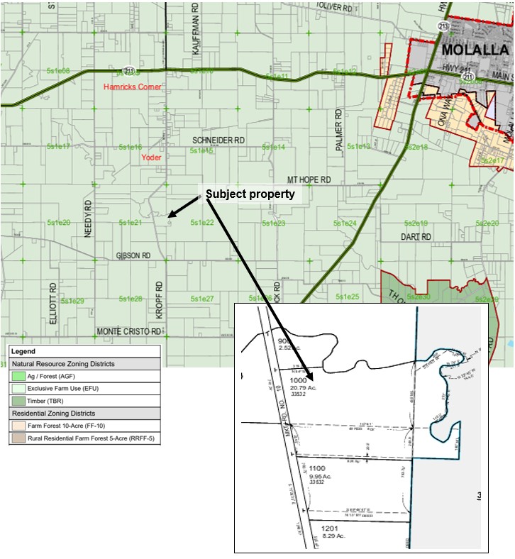
Source: Clackamas County maps
Subject Property and Surrounding Area:
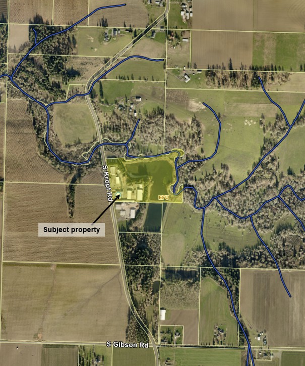
Source: Clackamas County PlanMap, 2025 aerial photo
Subject Property and Proposed Zone Change Area:
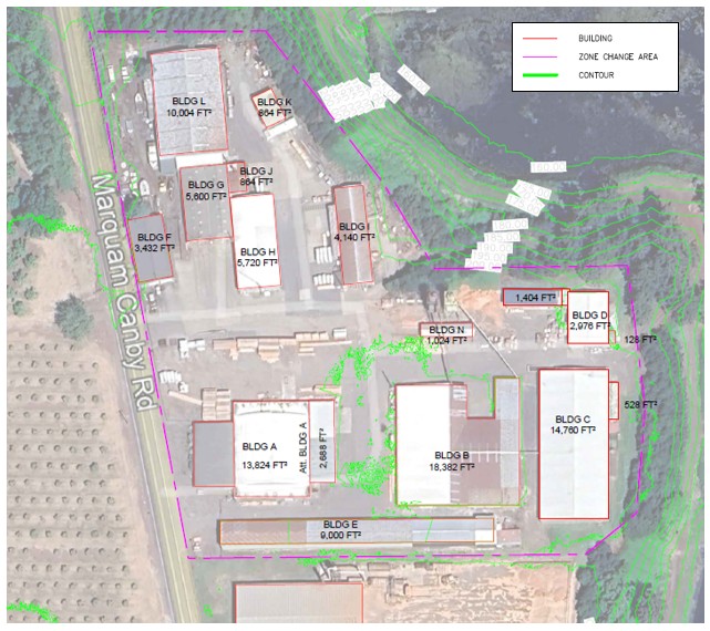
Source: Exhibit 1, Application (Exhibit 2B)
The developed area is shown above, with the pink line around Buildings “A” through “L” and “N” represent the area historically developed and used as the mill site and the area proposed for the Rural Industrial designation. According to the applicant, this development is served by one exempt-use well and two septic systems.
Based on information provided in the application, there exists a total of 92,750 square feet of building area on the subject property, which are currently being utilized as follows. Other historic uses on the site are discussed in detail in the application and summarized in the “land use history” section below.
| BLDG | SQ FT | Current Use |
|---|---|---|
| A | 13,824 | Vacant |
| B | 18,382 | Vacant |
| C | 15,288 | Storage: Wilco – farm store products |
| D (part) | 3,104 | Processing: Woodburn Pocket Door (from 2023) – Use pre-processed lumber and hardware to assemble finished framing components for installation |
| D (part) | 1404 | Vacant |
| E | 9,000 | Storage: Wilco – farm store products |
| F | 3,432 | Storage/office: Precision Drying |
| G | 5,600 | Kiln: Precision Drying |
| H | 5,720 | Storage/office: Precision Drying |
| I | 4,140 | Unknown: Precision Drying |
| J | 864 | Unknown: Precision Drying |
| K | 964 | Vacant |
| L | 10,004 | Storage/office: Precision Drying |
| N | 1,024 | Vacant |
In addition to this development on the subject property (taxlot 1000), the adjacent taxlot to the south (taxlot 1100) contains several buildings that were developed in association with uses on the subject property. The development on the adjacent taxlot 1100 is not subject to this application, however; and was not a part of the original mill site. This development includes three buildings – referred to as Buildings “O”, “P”, and “M” in the application - that were most recently being utilized for wood pellet production and storage. Those uses were approved as an expansion of the “nonconforming uses” on the subject taxlot shown above. The applicant notes that the pellet production business left this location in 2025 and those three buildings are presumably vacant.
Land Use History: The first restrictive zoning was the Exclusive Farm Use (EFU) designation, applied to the subject site on September 1, 1976. The EFU regulations have changed somewhat since 1976 and the county has adopted a number of amendments to the EFU district regulations over the years, but the types of industrial uses historically present on the subject property have never been listed as permitted uses in EFU.
As discussed in the application and below, the first “industrial” use established on the subject site was the lumber mill. Because it has been demonstrated that the mill was established prior to the first restrictive zoning, both the use and the structures on the site were considered lawfully established nonconforming uses.
Nonconforming uses are structures and/or uses of property that were legally established—either because they received land use approval or were allowed by right at the time of establishment—but that are now prohibited due to a change in the zoning regulations that apply to the property. Such uses are allowed to continue to operate and may be altered/changed as long as the nonconforming use has not been discontinued for a period of time, as determined in the county’s Zoning & Development Ordinance (ZDO).
The nonconforming uses and structures on the subject site have both been altered over time. Pages 1 through 8 of the application narrative provide a detailed description and photos describing the history of usage on the site. The nonconforming use determinations and alterations for the subject property over the last several decades is summarized below (Staff is making no formal determination with this application about whether this property has retained its nonconforming use status since the last approved alteration).
Z0092-93-E Verification and Alteration of a Nonconforming Use; found that the sawmill and wood products manufacturing and processing facility was a lawful nonconforming use, established in 1941. The application notes that the existing sawmill was still in operation in an enclosed building and that a wood pellet mill was needed in order to continue existing mill use, to help keep the operation economically feasible due to shortage of raw logs for milling.
Z0721-97-E Alteration of Nonconforming Use; permitted an addition to one of the existing buildings to provide for additional covered storage space.
Z0254-05-E Alteration of Nonconforming Use; allowed the inclusion of the adjacent taxlot 1100 to the nonconforming use and included authorization to use an existing manufactured home on that taxlot to be used as a residence for a watchman/caretaker for the mill facility. This approval included conditions of approval requiring that:
- taxlot 1100 be held in same ownership as taxlots 1000 and 1101 (currently combined into taxlot 1000)
- the home on taxlot 1100 be removed from the site if the nonconforming use, the wood processing operation is discontinued; and
- the home must be occupied only by a person or persons directly involved in the operation of management of the wood processing facility and immediate family members.
Z0408-06-E Alteration of a Nonconforming Use; permitted the construction and operation of three new structures – a 600 sq.ft. infeed hopper building, a 5,000 sq.ft. raw materials storage building and a 1,200 sq.ft. building housing a new pellet mill. The proposal was to expand pellet production because “the pellet mill is running at full capacity and cannot keep up with demand.” Building D is identified as the “pellet building”, but new buildings would locate on the adjacent taxlot (1100).
Z0716-06-E Alteration of a Nonconforming Use; included a major modification to Z0408-06-E. It authorized enlarging the approved, but not yet constructed, raw materials storage building to 12,320 sq.ft. of enclosed area with 4,312 sq.ft. of lean-to covered storage area to each side and the pellet mill building to 4,312 sq.ft. of enclosed space with 924 sq.ft. of lean-to covered storage area to each side.
The application noted that these facilities would increase production capacity by approximately 60% and require one additional employee and one to two additional truck trips per day. The new structures would be located on the adjacent taxlot 1100.
That application also noted that the “mill was established in 1941 and has been in continuous operation since that time… In the early 1960s the saw mill burned down. Since that time the dry kiln, wood fabrication, planning, and molding have continued. In the early 1990s a pellet mill was added to make more productive use of the wood waste. There are 13 industrial buildings ranging from 500 to 12,000 square feet. Days and hours of use and number of employees does fluctuate with the seasons, but over the years has been somewhat consistent.” The following uses are listed in the buildings
- Front Fabricating Shop and Office
- Planer Building
- Molding Building
- Pellet Building
- South Lumber Storage
- Machine Shop
- Dry Kiln
- Middle Lumber Shed
- Sticker Building
- Boiler Room
- Small Kiln
- North Lumber Storage
- Caretaker's Mobile Home
- Sawdust Bunker
- Purposed Raw Material Storage Building
- Purposed Pellet Mill Building
Z0472-13-E Alteration of Nonconforming Use; authorizing the construction of an approximately 10,080 sq.ft. building for storage and shipping use in conjunction with the existing pellet mill production in three other buildings on the adjacent taxlot (1100). This application also notes that the sites “are developed with 13 existing buildings currently used for the wood processing/lumber milling facility. Existing operations employ 30 persons. The hours of operation are from 5AM to 9 PM six days per week.”
Service providers:
- Sewer: The subject property is not located within a public or private sewer district. Current development on the site is served by septic systems. Any future development would also need to be served by an on-site wastewater system, subject to Clackamas County’s Septic and Onsite Wastewater Program’s rules and regulations.
- Water: The subject property is not located within a public or private water district. Current development on the site is served by a well. Any future development would also need to be served by a private well, subject to the Oregon Water Resources Department’s rules and regulations.
- Fire Protection: Monitor Fire District #58
Noticing: This application has been processed consistent with the legal noticing requirements in Section 1307, Procedures, of the County’s Zoning and Development Ordinance (ZDO) and with state noticing requirements. Specifically, the County has provided notice to interested agencies, local governments and property owners within 2,650 feet of the subject property consistent with State law and Section 1307 of the ZDO. The notification to property owners, public notices and hearings ensures an opportunity for citizens to participate in the land use process.
Responses received: To date, no comments have been received. The local Community Planning Organization, the South Canby CPO, is currently inactive.
Public Hearings: Two public hearings on the current proposal are scheduled: one before the Planning Commission on July 13, 2026, and another before the Board of County Commissioners (Board) on August 4, 2026. The Planning Commission makes a recommendation to the Board, who will ultimately decide whether the proposal is approved.
III. Findings
This application is subject to the following provisions:
- Statewide Planning (SWP) Goals
- Oregon Revised Statutes (ORS) 197.719, Industrial use of abandoned or diminished mill sites; amendment of comprehensive plans and land use regulations; sewer facilities
- Clackamas County Comprehensive Plan
- Zoning and Development Ordinance (ZDO) Sections 202, 1202, and 1307.
Staff have reviewed these provisions and the applicant’s preliminary findings in conjunction with this proposal. Compliance with the applicable regulations found in each is discussed below. ZDO Section 1307 provides only procedural requirements that do not warrant separate written findings in this report.
IV. Statewide Planning Goals
Goal 1 – citizen involvement
Statewide Planning Goal 1 calls for “the opportunity for citizens to be involved in all phases of the planning process” and requires the County to have a citizen involvement program with certain features.
This application only proposes to amend the County’s Comprehensive Plan maps and zoning map. Even if approved, the County’s existing, State-acknowledged citizen involvement program would not change.
ZDO Section 1307, Procedures, contains acknowledged procedures for citizen involvement and public notice of quasi-judicial applications. This application has been processed consistent with those requirements, including providing notice to property owners within 2,650 feet of the subject property; the Department of Land Conservation and Development (DLCD); 1000 Friends of Oregon; and other interested agencies. Notice of the application and its public hearings has also been published in the newspaper and on County webpages.
Before the Board of County Commissioners can decide on this application, there will have been at least two public hearings with opportunity for interested parties to testify. The public has also been given the opportunity to provide written comments, and all comments provided to date have been included in the record.
The relevant requirements of Statewide Planning Goal 1 are satisfied.
Goal 2 – land use planning
Goal 2 requires the County to have and to follow a comprehensive land use plan and implementing regulations. Comprehensive plan provisions and regulations must be consistent with Statewide Planning (SWP) Goals. This proposed amendment to the County’s Comprehensive Plan maps, including Map 4-07a, would not change the County’s land use planning process. This report outlines how this proposal is consistent with all applicable county land use regulations and policies.
Goal 2 also provides a process by which exceptions can be made to certain SWP Goals. However, this application has been submitted pursuant to ORS 197.719, which permits land that meets the statutory definition of an “abandoned or diminished mill site” to be rezoned for industrial use without requiring a goal exception.
The relevant requirements of Statewide Planning Goal 2 are satisfied.
Goal 3 – agricultural lands
Goal 3 requires the County to identify farmland, designate it as such on its Comprehensive Plan maps, and zone it Exclusive Farm Use (EFU).
The County has already satisfied these requirements. This proposal would change the designation of the subject property from agricultural to rural industrial. As noted in this report, the portion of the subject property proposed for rezoning contains mapped Class 2 agricultural soils that have been significantly impacted by development for over 80 years. Further state law, under ORS 197.719 allows for land that meets the statutory definition of an “abandoned or diminished mill site” to be rezoned for industrial use, notwithstanding other land use regulations that protect farm or forest land. As is discussed below, the development on the subject site has been found to meet the statutory definition of and “abandoned or diminished mill site” and can therefore be rezoned to a Rural Industrial designation without regard for soil type and without taking an exception to Goal 3.
The relevant requirements of Statewide Planning Goal 3 are satisfied.
Goal 4 – Forest lands
Goal 4 requires the County to identify forest lands, designate it as such on Comprehensive Plan maps, and zone it consistently with State rules.
The County has already satisfied these requirements. This application does not propose to change the Comprehensive Plan or zoning designation of any forest land, nor does it propose a change in any allowed land use in the County’s forest zones (i.e., Ag/Forest and Timber). The subject property is currently designated as agricultural land, not forest land.
Statewide Planning Goal 4 is not applicable.
Goal 5 – Natural resources, scenic and historic areas, and open spaces
Goal 5 requires the County to adopt programs that will protect an area’s natural resources and will conserve scenic, historic, and open space resources for present and future generations. It requires an inventory of natural features, groundwater resources, energy sources, and cultural areas, and encourages the maintenance of inventories of historic resources.
This proposal would not change the County’s acknowledged inventories or programs for the protection of such resources nor would it modify the mapping of any protected resource. As noted previously, the subject site does contain Goal 5 resources – a pond and a regulated stream – but those resource areas will retain their existing EFU designation; only the developed, western portion of the site (approximately 7.5 acres) would be redesignated as Rural Industrial.
The relevant requirements of Statewide Planning Goal 5 are satisfied.
Goal 6 – air, water, and land resources quality
Goal 6 instructs the County to consider the protection of air, water, and land resources from pollution and pollutants when developing its Comprehensive Plan.
This proposal would not change the County’s acknowledged Comprehensive Plan policies or implementing regulations regarding Goal 6 resources, nor would it modify the mapping of any protected resource.
Statewide Planning Goal 6 is not applicable.
Goal 7 – Areas subject to natural hazards
Goal 7 requires the County to address Oregon’s natural hazards.
This proposal would not change the County’s acknowledged Comprehensive Plan policies or implementing regulations regarding natural disasters and hazards, nor would it modify the mapping of any hazard.
As noted previously, the subject site does not contain any mapped flood hazard or mass movement areas but does contain some steep slopes. These steep slopes, however, are adjacent to and associated with the large pond, which will retain its existing EFU designation. Only the flatter, already-developed portion of the site (approximately 7.5 acres) would be redesignated as Rural Industrial.
The relevant requirements of Statewide Planning Goal 7 are satisfied.
Goal 8 – recreational needs
Goal 8 requires the County to plan for the recreational needs of its residents and visitors.
This proposal would not change the County’s acknowledged Comprehensive Plan policies or implementing regulations regarding recreational needs and would not modify the mapping of a recreational resource. The subject site does not contain any areas with identified Goal 8 resources.
Statewide Planning Goal 8 is not applicable.
Goal 9 – economic development
The purpose of Goal 9 planning is to provide adequate opportunities throughout Oregon for a variety of economic activities vital to the health, welfare, and prosperity of Oregonians.
Goal 9 is implemented by Oregon Administrative Rules (OAR) Chapter 660, Division 9. Pursuant to OAR 660-009-0010(1), the requirements of division 9 apply only within urban growth boundaries (UGBs). As noted, the subject property is not within a UGB. Therefore, Goal 9 is not applicable to this amendment. Nonetheless, this amendment would further Goal 9 generally by providing economic support and employment opportunities for the rural area of the county because it would allow for more diverse types of industrial businesses to locate on the subject site than could do so through a continuation of the nonconforming use status.
This proposal is consistent with Goal 9.
Goal 10 – housing
The purpose of Goal 10 is to meet housing needs.
Goal 10 recommends that the County’s Comprehensive Plan (including its land use designation maps) “should be developed in a manner that insures the provision of appropriate types and amounts of land” within UGBs for housing; it also advises that areas planned for residential development “be necessary and suitable for housing needs of households of all income levels”.
The requirements under Goal 10 do not apply outside of a UGB, where the subject site is located.
Statewide Planning Goal 10 is not applicable.
Goal 11 – Public Facilities and services
The purpose of Goal 11 is to ensure that local governments plan and develop a timely, orderly, and efficient arrangement of public facilities and services to serve as a framework for urban and rural development. Goal 11 is implemented by OAR Chapter 660, Division 11.
This proposal would not change any adopted facilities plans or implementing regulations. The subject site is currently not served by public water or public sewer and, because it is outside of an urban growth boundary (UGB), it will not be served by these public facilities. Any future development on the site would continue to be served by the on-site sewage disposal and water facilities.
The relevant requirements of Statewide Planning Goal 11 are satisfied.
Goal 12 – transportation
The purpose of Goal 12 is to provide and encourage a safe, convenient, and economic transportation system. It requires the County to create a transportation system plan (TSP) that takes into account all relevant modes of transportation.
Goal 12 is implemented by OAR chapter 660, division 12, commonly referred to as the Transportation Planning Rule (TPR). When an amendment to the County’s Comprehensive Plan map or zoning map is proposed, OAR 660-012-0060 requires an analysis of whether the proposed amendment would “significantly affect” an existing or planned transportation facility, and whether it is necessary to update transportation facility plans to accommodate such effects. The TPR defines what it means to “significantly affect” a transportation facility.
The applicant has provided a traffic study, prepared by a licensed engineering firm, Mackenzie, and dated October 15, 2025. The traffic analyses address TPR requirements and include a comparison of the reasonable worst-case traffic impacts caused by potential development of the subject property under the property’s current zoning.
This analysis notes that “the applicant proposed to limit the site to the exiting building footprint” and bases the traffic analysis on an assumption of 87,100 square feet of building space for manufacturing. The analysis concludes that “…[b]ased on a worst-case scenario under RI zoning, the site would have potential for an increased trip generation over the current trip generation. The increase would not result in a significant effect on the capacity, classification or safety of the transportation system. The proposed land use actions will result in a small increase in traffic and will not significantly affect an existing or planned transportation facility.
County Engineering staff have reviewed the traffic study and concur with the assumptions and findings, provided the approval includes a condition limiting the potential development/use intensity consistent with the assumptions in the traffic analysis. Engineering staff notes that “[t]he applicant’s analysis assumes the RI-zoned area would be limited to the existing building footprint and evaluates a reasonable worst-case manufacturing use, resulting in 58 PM peak-hour trips, or a net increase of 53 PM peak-hour trips. Based on the submitted analysis, the study intersections are projected to operate within applicable County and ODOT mobility standards, and the proposed zone change is not expected to significantly affect the adequacy of the transportation system (see Exhibit 3).
With conditions, the relevant requirements of Statewide Planning Goal 12 are satisfied.
Goal 13 – energy conservation
Goal 13 encourages land use plans to consider lot size, siting controls, building height, density, and other measures in order to help conserve energy.
This proposal would not change the County’s acknowledged Comprehensive Plan policies or implementing regulations regarding energy conservation.
Statewide Planning Goal 13 is not applicable.
Goal 14 – urbanization
The purpose of Goal 14 is to provide for an orderly and efficient transition from rural to urban land use, to accommodate urban population and urban employment inside urban growth boundaries, to ensure efficient use of land, and to provide for livable communities.
The application does not propose to expand or modify any UGB or to permit rural land uses inside the UGB.
Statewide Planning Goal 14 is not applicable.
Goal 15 – willamette river greenway
The purpose of Goal 15 is to “protect, conserve, enhance, and maintain the natural, scenic, historical, agricultural, economic, and recreational qualities of lands along the Willamette River as the Willamette River Greenway.”
The subject property is more than 11 miles from the Willamette River and is therefore well outside the Willamette River Greenway. The applicant’s proposal would not change the county’s acknowledged Comprehensive Plan policies or implementing regulations regarding the Willamette River Greenway.
Statewide Planning Goal 15 is not applicable.
Goal 16 – estuarine resources; Goal 17 – Coastal Shorelands; Goal 18 – beaches and dunes; Goal 19 – ocean resources
Statewide Planning Goals 16 through 19 are not applicable to Clackamas County.
B. Oregon Revised Statutes (ORS)
The subject property is designated as natural resource land (Agriculture) on the Comprehensive Plan Map. Generally, to change the Comprehensive Plan Map designation to any plan designation other than Agriculture or Forest, it is necessary to take an exception to Statewide Planning (SWP) Goal 3, under the procedure described in the Oregon Administrative Rules (OAR) 660, Division 4. However, state law allows for a zone change without a goal exception specifically for an “abandoned or diminished mill site”. This application proposes to utilize these criteria, as set forth in ORS 197.719.
ORS 197.719, Industrial use of abandoned or diminished mill sites; amendment of comprehensive plans and land use regulations; sewer facilities.
ORS 197.719(1) defines an “abandoned or diminished mill site” as follows:
a mill, plant or other facility engaged in the processing or manufacturing of wood products, including sawmills and facilities for the production of plywood, veneer, hardboard, panel products, pulp and paper, that:
- Is located outside of urban growth boundaries;
- Was closed after January 1, 1980, or has been operating at less than 25 percent of capacity since January 1, 2003; and
- Contains or contained permanent buildings used in the production or manufacturing of wood products.
Similarly, the county’s Zoning and Development Ordinance (ZDO) Section 202, Definitions, includes the following definition:
MILL SITE, ABANDONED OR DIMINISHED: A mill, plant, or other facility engaged in the processing or manufacturing of wood products, including sawmills and facilities for the production of plywood, veneer, hardboard, panel products, pulp, and paper, that is located outside of urban growth boundaries; was closed after January 1, 1980, or has been operating at less than 25 percent of capacity since January 1, 2003; and contains or contained permanent buildings used in the production or manufacturing of wood products
The first step in understanding in the proposal qualifies for redesignation under ORS 197.719 is to determine whether the site meets the statutory definition of an “abandoned or diminished mill site”. In this case, despite the somewhat complicated history of uses on the site, this determination is fairly straightforward due to the current usage of the buildings on the site – including a number of vacant buildings, buildings utilized for storage, and two businesses that utilize wood products processed elsewhere to produce different products. Regarding this determination, staff finds the following:
- The subject property is not located within an urban growth boundary.
- The site contains 13 permanent buildings that were historically used in the production or manufacturing of wood products as defined in ORS 197.719(1).
Evidence in the record indicates that the sawmill portion of the mill site had ceased operations by 2000. In an email dated 10/11/2000 (see Application, Exhibit 3B, pg. 4 of 22), the emailer states: “I am considering the purchase of a "non-conforming use property in rural Clackamas County. The address is 33532 Kropf Road, Molalla, 97038…MAP: 51E21 01000…It is on 20.4 acres. There is an unused, old 12 acre log pond and the remaining 8 acres are black topped around 12 buildings (total of 75,000 sq. ft.). Current zoning for the property is EFU, but.the property was established as a saw and lumber mill in the 1948 and has been in continuous operation since that time. The sawing of logs has not been done for many years, but lumber drying, planing and shaping has continued. The current tenant, Mullen Lumber, Inc., is in the business of manufacturing different millwork, tongue and groove ceiling boards, closet rods, etc. His manufacturing operation occupies only a portion of the buildings and his lease would continue if I were to buy the property.
Additional evidence also indicates that the sawmill operations were “abandoned” or discontinued after January 1, 1980. As noted in the 1993 land use file (Z0092-93-E), the sawmill was still in operation in an enclosed building.
- The history of facilities on the site engaged in “wood processing” is more complicated by the fact that the statute narrows the definition of a “mill site” by the using the language “including… “facilities for the production of plywood, veneer, hardboard, panel products, pulp and paper”. While the applicant asserts that the use of the term “including” means that only those facilities producing the six listed items, staff disagrees. Based on the caselaw identified by the applicant, the definition is not limited to only those six things (plywood, veneer, hardboard, panel products, pulp and paper). Instead, it is limited to wood products of the same type as those six things. A court would try to figure out whether whatever this facility produces and the six things listed in ORS 197.719(1) share any characteristic traits. In Liberty v. ODOT, the court states: “When the legislature uses “nonspecific or general phrases” as well as a list of items, this court, under the principle of ejusdem generis, construes the statute “as referring only to other items of the same kind.” Vannatta v. Keisling, 324 Or 514, 533, 931 P2d 770 (1997) (stating and applying principle). See also Lewis v. CIGNA Ins. Co., 339 Or 342, 350-51, 121 P3d 1128 (2005) (under ejusdem generis rule, court examines “basic characteristics” of enumerated items when construing more general words).
- The applicant further complicates the analysis by referring to the site as either “abandoned” or “diminished” in various locations in the application materials. They provided testimony that mill closed (or “abandoned”) in 1999, but that testimony is in direct contradiction to the evidence provided in the cited land use approvals for the alterations to the nonconforming uses. The applicant also asserts that because the mill site no longer operates as a sawmill or as a facility producing the specific wood products identified in ORS 197.719(1) and instead has been occupied only by downstream specialty wood products companies, and other storage uses, the site qualifies as a “diminished mill site” under ORS 197.719(1). Again, staff disagrees. For a mill site to be “diminished” evidence must demonstrate that the mill had been operating at less than 25 percent of capacity since January 1, 2003. No such evidence has been provided. However, to demonstrate a mill has been “abandoned”, under this statutory definition, one need only demonstrate that the “mill site” had been in operation and then closed after January 1, 1980.
At issue here, since evidence clearly points to the mill being in operation well past January 1, 1980, is whether the operations at the mill site currently meet the definition in ORS 197.719 and if not, whether they ceased at some point after January 1, 1980. Based on the application materials, the distribution of current uses by square footage can be summarized as follows
- 38% vacant
- 26% farm store storage
- 21% storage and offices for lumber “redrying” business
- 11% kilns or unknown uses for lumber “redrying” business
- 3% pocket door fabrication, assembly
Clearly the vacant buildings and those used for storage for a farm store do not meet the definition of “mill site” as they are either not used or are used to store materials not related to wood processing.
Additionally, staff finds that the “drying” business, including some kiln uses on the property do not meet the definition under ORS 197.719. These uses are not similar in “character” to the sawmill or identified production facilities because they are not using raw materials or even materials milled or processed on the subject site, but are bringing in already-processed the lumber to store and “redry”. As noted in an email from April 2017 regarding an authorization for replacing a kiln in same locations as was verified/approved in 1993, the stated purpose of the kiln was “redrying lumber that has been pressure treated at another location…there are two other kilns on the site in operation with the same purpose.” (see Exhibit 2),
The pocket door fabrication business is described as using “pre-processed lumber and hardware to assemble finished framing components for installation.” Again, this use is simply assembling a product utilizing already-processed lumber and other materials.
As such, staff finds that the site can be found to meet the statutory definition of an “abandoned” mill site.
Staff notes the perceived contradiction with this conclusion that the mill site is “abandoned”, given the history of alterations of nonconforming uses on the site but contends that simply because the site has continued to be used does not necessarily mean that is has been used in ways that meet the statutory definition of an “abandoned or diminished mill site” in ORS197.719. Evidence in the record demonstrates that the nonconforming uses have actually changed in character over the years, becoming more removed from raw material, or primary, processing to include secondary wood-related uses including wood pellet, or biofuel, production or to include just storage. Even the kiln use has changed over the years, from supporting or accessory to the sawmill and wood processing facilities to a facility to “redry” lumber that is processed on a different site.
- 38% vacant
In summary, while staff does not concur with the entire analysis and findings provided by the applicant, staff does concur with the conclusion that the site meets the statutory definition of an “abandoned or diminished mill site”. None of the current uses on the property fall under the “mill site” definition and evidence clearly demonstrates the mill site was in operation before but “abandoned” sometime after January 1, 1980. This application can therefore proceed for consideration of an industrial designation under ORS 197.719. This criterion is met.
ORS 197.719 (2) Notwithstanding statewide land use planning goals protecting agricultural lands or forestlands or administrative rules implementing those goals, the governing body of a county may amend the county’s comprehensive plan and land use regulations to allow an abandoned or diminished mill site to be zoned for industrial use.
This provision authorizes the county to rezone an abandoned or diminished mill site to an industrial designation without the need for a Goal 3 exception. Because staff finds that the site does meet the statutory definition of an “abandoned or diminished mill site” the county’s Comprehensive Plan and zoning designations may be changed to industrial designations without a goal exception or further consideration of rules implementing Goal 3. This criterion is met.
ORS 197.719 (3) Notwithstanding a statewide land use planning goal relating to urbanization or administrative rules implementing that goal, the governing body of a county may amend the county’s comprehensive plan and land use regulations to allow an abandoned or diminished mill site to be zoned for any level of industrial use.
The applicant has proposed the Rural Industrial (RI) District, which allows for industrial and other compatible uses that are compatible with the rural area and do not have a need for urban services like public sewer or water. This criterion is met.
ORS 197.719 (4) Notwithstanding a statewide land use planning goal relating to public facilities and services or administrative rules implementing that goal, the governing body of a county or its designee may approve:
(a) The extension of sewer facilities to lands that on June 10, 2003, are zoned for industrial use and that contain an abandoned or diminished mill site. The sewer facilities may serve only industrial uses authorized for the mill site and contiguous lands zoned for industrial use.
(b) The extension of sewer facilities to an abandoned or diminished mill site that is rezoned for industrial use under this section only as necessary to serve industrial uses authorized for the mill site.
(c) The establishment of on-site sewer facilities to serve an area that on June 10, 2003, is zoned for industrial use and that contains an abandoned or diminished mill site or to serve an abandoned or diminished mill site that is rezoned for industrial use under this section. The sewer facilities may serve only industrial uses authorized for the mill site and contiguous lands zoned for industrial use.
This criterion is not applicable; sewer service is not proposed for the subject site.
ORS 197.719 (5) (a) A local government, as defined in ORS 174.116, may not authorize a connection to any portion of a sewer facility located between an urban growth boundary or the boundary of an unincorporated community and the boundary of the mill site or the industrial zone containing the mill site, except as provided under a statewide land use planning goal relating to public facilities and services or under ORS 197.732.
(b) Sewer facilities approved under subsection (4) of this section shall be limited in size to meet the needs of authorized industrial uses and may not provide service to retail, commercial or residential development, except as provided under a statewide land use planning goal relating to public facilities and services or under ORS 197.732. The presence of the sewer facilities may not be used to justify an exception to statewide land use planning goals protecting agricultural lands or forestlands or relating to urbanization.
This criterion is not applicable; sewer service is not proposed for the subject site.
ORS 197.719 (6) (a) The governing body of a county or its designee shall determine the boundary of an abandoned or diminished mill site. For an abandoned or diminished mill site that is rezoned for industrial use under this section, land within the boundary of the mill site may include only those areas that were improved for the processing or manufacturing of wood products.
The area proposed for resignation to industrial is identified in the map on page 6 of this report. The area is narrowly drawn around the existing development on the site, including the 13 buildings and surface parking and storage areas. The existing pond and creek found on the eastern and northeastern portions of the site are not included in this area. The area proposed for redesignation totals approximately 7.5 acres and, based on historic aerial photos and land use approvals, includes the area of the mill that was originally established in 1941 and continued to operate as a “mill site” well past 1980.
This criterion is met.
(b) For an abandoned or diminished mill site subject to subsection (2), (3) or (4) of this section, the governing body of a city or county or its designee may approve a permit, as defined in ORS 215.402 or 227.160, only for industrial development and accessory uses subordinate to such development on the mill site. The governing body or its designee may not approve a permit for retail, commercial or residential development on the mill site.
Current usage of structures is industrial and includes processing, manufacturing, and warehousing. If approved, a condition of approval is warranted limiting the uses on the subject site to only industrial and prohibiting retail, commercial, or residential development. This condition will be further limited by the assumptions used in the traffic analysis, to include only manufacturing and other industrial uses with lower demonstrated trip generation.
With conditions, this criterion can be met.
ORS 197.719 (7) For land that on June 10, 2003, is zoned under statewide land use planning goals protecting agricultural lands or forestlands and that is rezoned for industrial use under subsections (2) and (3) of this section, the governing body of the county or its designee may not later rezone the land for retail, commercial or other nonresource use, except as provided under the statewide land use planning goals or under ORS 197.732.
If approved, a condition of approval is warranted prohibiting the rezoning of the subject property except as provided under the statewide land use planning goals or under ORS 197.732.
With conditions, this criterion can be met.
Based on the above findings, the proposal meets all applicable criteria in ORS 197.719 for the redesignation of an “abandoned or diminished mill site” from Exclusive Farm Use (EFU) to an industrial designation.
C. Clackamas County Comprehensive Plan (Plan)
The County’s Comprehensive Plan includes goals and policies that must be considered when evaluating a proposed change in Comprehensive Plan. Staff have reviewed each chapter of the Comprehensive Plan. This section of the report outlines whether the applicant’s proposal is consistent with the applicable goals and policies.
Chapter 2; Citizen Involvement: The purpose of this Chapter is to promote citizen involvement in the governmental process and in all phases of the planning process.
There is one policy in this Chapter applicable to this application:
Policy 2.A.1 Require provisions for opportunities for citizen participation in preparing and revising local land use plans and ordinances. Insure opportunities for broad representation, not only of property owners and County wide special interests, but also of those within the neighborhood or areas in question.
The Comprehensive Plan and ZDO include acknowledged procedures for citizen involvement. This application has been processed consistent with those procedures. Specifically, the County has provided notice to interested agencies, local governments, and nearby property owners, consistent with state law and ZDO Section 1307, which implements the public notice policies of Chapter 2. Notice to property owners, public notices, and hearings ensure an opportunity for citizens to participate in the land use process.
This application is consistent with Chapter 2.
Chapter 3, Natural Resources and Energy: The purpose of this Chapter is to provide for the planning, protection and appropriate use of the County's natural resources and energy.
This Chapter contains eight (8) Sections addressing; 1) Water Resources; 2) Agriculture; 3) Forests; 4) Mineral and Aggregate Resources; 5) Wildlife Habitats and Distinctive Resource Areas; 6) Natural Hazards; 7) Energy Sources and Conservation and; 8) Noise and Air Quality.
As noted previously, the subject site is within a sensitive groundwater area, identified as Groundwater Limited Areas by the state. Chapter 3 contains policies related to Groundwater Limited Areas, but they are all directive to county actions and are not applicable to zone changes.
Also noted previously, the subject property contains a pond and is bound on the east and northeast by Rock Creek. Both of these areas are identified as wetlands in Department of State Lands (DSL) Wetland Inventory and two wetland-related policies found in Chapter 3 are applicable to the subject proposal.
Policy 3.F.1 For areas that are outside both the Metropolitan Service District Boundary and the Portland Metropolitan Urban Growth Boundary, prevent disturbance of natural wetlands (marshes, swamps, bogs) associated with river and stream corridors. Adjacent development shall not substantially alter normal levels or rates of runoff into and from wetlands. Site analysis and review procedures specified in the Open Space and Floodplains section of the Land Use chapter shall apply. (See Wildlife Habitats and Distinctive Resource Areas of this chapter).
Policy 3.F.1 was included in the acknowledged Comprehensive Plan in order to comply with Statewide Planning Goal 5, for wetland resources. Outside of the Urban Growth Boundary (except in parts of the Mt. Hood area) the federal wetland inventory is so general (just based on aerial flyovers) that it has not been possible to determine the exact location, quality, or quantity of wetlands. The County has not had the resources in order to develop more in depth or County specific wetland mapping. As such, policy 3.F.1 was adopted so that the County would review significant developments- including zone changes- to assure consistency with Goal 5 for wetland resources.
As noted, the DSL Statewide Wetland Inventory identified a riverine wetland (Rock Creek) and a freshwater “log pond” on site. However, the portion of the site proposed for redesignation is located outside these mapped wetland areas and is already impacted by development, including numerous buildings and surface parking and storage areas. None of the area to be redesignated as “industrial” contains wetlands. And any redevelopment or new development for industrial uses on the site would be confined to within the area that has been developed for more than 80 years.
DSL was notified but has not provided any comment on this proposal. Any future proposal for a building permit would be noticed to DSL; and any proposed removal or fill of the wetlands exceeding 50 cubic yards would require a permit from the State.
As such, Staff finds is reasonable to conclude that the proposed zone change would not result in the disturbance of natural wetlands (marshes, swamps, bogs) and therefore the proposal is consistent with the Policy 3.F.1 of the Comprehensive Plan. This policy is met.
Policy 3.K.5. Minimize adverse wildlife impacts in sensitive habitat areas, including deer and elk winter range below 3,000 feet elevation, riparian areas, and wetlands.
Approval of the proposed zone change is expected to have a minimal impact on the surrounding area, including any habitat, for three main reasons: (1) the area proposed for redesignation has been developed with industrial uses for over 80 years; (2) if approved, any new rural industrial development would be confined to within the in area already developed on the site; and (3) as conditioned, no net increase in square footage of building area could be developed on the site.
This policy is met.
Chapter 4 Land Use: This Section of the Comprehensive Plan includes the definitions for urban and rural land use categories, and outlines policies for determining the appropriate Comprehensive Plan land use designation for all lands within the County.
This chapter contains sections addressing (1) Urbanization, (2) Urban Growth Concepts, and (3) land use policies for each designation. The land use policies for the existing and proposed designations are addressed below.
Policy 4.NN.10 Except on lands within urban growth boundaries or as provided by the Oregon Revised Statutes for abandoned or diminished mill sites, exceptions to Statewide Planning Goals 3 and 4 shall be required for a plan amendment from the Agriculture designation to any designation other than Forest.
This policy explains under what circumstances an exception to Statewide Planning Goal 3 would and would not be required. This proposal includes a request for a Rural Industrial Plan designation as provided by the Oregon Revised Statutes for abandoned and diminished mill sites, and therefore a Goal exception is not required. This policy is met.
Rural Industrial Policies
Rural lands are defined in the Comprehensive Plan as “exception lands, as defined in Oregon Administrative Rules 660-004-0005(1), that are outside urban growth boundaries and Unincorporated Communities and are suitable for sparse settlement such as small farms, wood lots or acreage home sites. They lack public facilities or have limited facilities and are not suitable, necessary, or intended for urban, agricultural, or forest use.”
Policy 4.LL.1. The Rural Industrial plan designation may be applied in non-urban areas to provide for industrial uses that are not labor-intensive and are consistent with rural character, rural development, and rural facilities and services.
The subject property is located in a non-urban area (outside any urban growth boundary). The industrial uses that are allowed within a Rural Industrial (RI) area, per Section 604 of the county’s Zoning and Development Ordinance (ZDO) are those that have been determined as appropriate for rural areas and commensurate with rural development. In addition, development on the subject site would be further limited by a condition of approval allowing only certain rural industrial uses on the subject site. This policy is met.
Policy 4.LL.2. The Rural Industrial (RI) zoning district implements the Rural Industrial plan designation.
If this proposal is approved, both the Plan designation and zoning designation would be changed to Rural Industrial. This policy is met.
Policy 4.LL.3 Areas may be designated Rural Industrial when the first, the second, or both of the other criteria are met:
4.LL.3.1 Areas shall have an historical commitment to industrial uses; or
4.LL.3.2 The site shall be an abandoned or diminished mill site, as defined in the Zoning and Development Ordinance, provided that only the portion of the site that was improved for the processing or manufacturing of wood products may be designated Rural Industrial; or
4.LL.3.3 Areas shall be located within an Unincorporated Community; and
4.LL.3.4 The site shall have direct access to a road of at least an arterial classification.
While it is clear that the subject property does have an historical commitment to industrial uses only the first or second criteria needs to be met to allow a Rural Industrial designation. In this case, the subject site also qualifies under 4.LL.3.2 because it has been determined that the site meets the statutory definition of an “abandoned or diminished mill site” and only the portion of the site that was improved for the mill facilities would be designated as industrial. As such, no further findings of historical commitment are necessary and this policy is met.
This application is consistent with Chapter 4.
Chapter 5 Transportation: This Chapter outlines policies addressing all modes of transportation and contains eight Sections including 1) Foundation and Framework; 2) Land Use and Transportation; 3) Active Transportation; 4) Roadways; 5) Transit; 6) Freight, Rail, Air, Pipelines and Water Transportation; 7) Finance and Funding; and 8) Transportation Projects and Plans.
There is only one policy in this chapter applicable to this application:
Policy 5.F.6 Require changes in land use plan designation and zoning designation to comply with the Transportation Planning Rule [Oregon Administrative Rules (OAR) 660-012-0060].
The applicant’s submitted traffic analysis, which was completed by a licensed engineer, finds that with this proposal, the TPR criteria outlined in OAR 660-012-0060 and Policy 5.F.6 are satisfied; the existing transportation infrastructure is considered sufficient to accommodate the proposed zone change.
County Engineering staff have reviewed the traffic study and concur with the assumptions and findings, provided the approval includes a condition limiting the potential development/use intensity consistent with the assumptions in the traffic analysis. Engineering staff notes that “[t]he applicant’s analysis assumes the RI-zoned area would be limited to the existing building footprint and evaluates a reasonable worst-case manufacturing use, resulting in 58 PM peak-hour trips, or a net increase of 53 PM peak-hour trips. Based on the submitted analysis, the study intersections are projected to operate within applicable County and ODOT mobility standards, and the proposed zone change is not expected to significantly affect the adequacy of the transportation system (see Exhibit 3).
With conditions, this application is consistent with Chapter 5.
Chapter 11 The Planning Process: The purpose of this Chapter is to establish a framework for land use decisions that will meet the needs of Clackamas County residents, recognize the County's interrelationships with its cities, surrounding counties, the region, and the state, and insure that changing priorities and circumstances can be met.
There is only one policy in this chapter applicable to this application:
Policy 11.A.1 Participate in interagency coordination efforts with federal, state, Metro, special purpose districts and cities. The County will maintain an updated list of federal, state and regional agencies, cities and special districts and will invite their participation in plan revisions, ordinance adoptions, and land use actions which affect their jurisdiction or policies.
Notice of this application has been provided to all appropriate agencies and parties, and advertised public hearings before the Planning Commission and the Board of County Commissioners provide an adequate opportunity for interagency coordination of this proposed Comprehensive Plan map amendment and demonstrates compliance with this policy.
This application is consistent with Chapter 11.
D. Zoning & Development Ordinance (ZDO)
Section 1202, Zone Changes, provides standards, criteria, and procedures under which a change to the County’s zoning map may be approved. Staff has reviewed the subsections of Section 1202 relevant to this application and makes the following findings.
Section 1202.02, Submittal Requirements
Section 1202.02 lists the information that must be included in a complete application for a zone change.
The application was initially submitted on October 21, 2025, and deemed incomplete. The applicant submitted additional materials on March 9, 2026, and the application was deemed complete that same day.
Section 1202.03, General Approval Criteria
Section 1202.01 states that a zone change may be allowed, after a hearing conducted pursuant to Section 1307, if the applicants provide evidence substantiating the following criteria found in Subsection 1202.03 are met.
Subsection 1202.03(A): The proposed zone change is consistent with the applicable goals and policies of the Comprehensive Plan.
Findings against the relevant Comprehensive Plan policies are detailed in Section III.C of this Staff Report (pages 19 to 23). Based on those findings, staff finds that the proposed zone change is compliant with all relevant goals and policies in the Comprehensive Plan.
This application is consistent with Subsection 1202.03(A).
Subsection 1202.03(B): If development under the proposed zoning district designation has a need for any of the following public services, the need can be accommodated with the implementation of the applicable service provider’s existing capital improvement plan: sanitary sewer, surface water management, and water. The cumulative impact of the proposed zone change and development of other properties under existing zoning designations shall be considered.
Development that could occur on the subject site under this proposal would not have access to or need public sewer or water service.
The applicant has submitted a Preliminary Statement of Feasibility, signed by a representative of county Engineering on November 12, 2025, indicating that adequate surface water treatment is available or can be made available for future development that could occur under this proposal.
This application is consistent with 1202.03(B).
Subsection 1202.03(C): The transportation system is adequate and will remain adequate with approval of the proposed zone change. For purposes of this criterion:
- Adequate means a maximum volume-to-capacity ratio (v/c), or a minimum level of service (LOS), as established by Comprehensive Plan Tables 5-2a, Motor Vehicle Capacity Evaluation Standards for the Urban Area, and 5-2b, Motor Vehicle Capacity Evaluation Standards for the Rural Area.
- The evaluation of transportation system adequacy shall be conducted pursuant to the Transportation Planning Rule (Oregon Administrative Rules 660-012- 0060).
- It shall be assumed that the subject property is developed with the primary use, allowed in the proposed zoning district, with the highest motor vehicle trip generation rate.
- The methods of calculating v/c and LOS are established by the Clackamas County Roadway Standards.
- The adequacy standards shall apply to all roadways and intersections within the impact area of the proposed zone change. The impact area shall be identified pursuant to the Clackamas County Roadway Standards.
- A determination regarding whether submittal of a transportation impact study is required shall be made based on the Clackamas County Roadway Standards, which also establish the minimum standards to which a transportation impact study shall adhere.
- Notwithstanding Subsections 1202.03(C)(4) through (6), motor vehicle capacity calculation methodology, impact area identification, and transportation impact study requirements are established by the ODOT Transportation Analysis Procedures Manual for roadways and intersections under the jurisdiction of the State of Oregon.
Subsections 1202.03(C)(1) to (7) define what is meant by an “adequate” transportation system.
The applicant’s submitted traffic analysis, which was completed by a licensed engineer, finds that with this proposal, the TPR criteria outlined in OAR 660-012-0060 are satisfied; the existing transportation infrastructure is considered sufficient to accommodate the proposed zone change.
The applicant’s submitted traffic analysis, which was completed by a licensed engineer, finds that with this proposal, the TPR criteria outlined in OAR 660-012-0060 and Policy 5.F.6 are satisfied; the existing transportation infrastructure is considered sufficient to accommodate the proposed zone change. County Engineering staff have reviewed the traffic study and concur with the assumptions and findings, provided the approval includes a condition limiting the potential development/use intensity consistent with the assumptions in the traffic analysis.
With conditions, this application is consistent with 1202.03(C).
Subsection 1202.03(D): Safety of the transportation system is adequate to serve the level of development anticipated by the proposed zone change.
The applicant’s traffic study also included an evaluation of crash rates in the identified study area, noting specifically the following:
“Intersection crash rates were calculated as a measure of the number of crashes occurring per one million entering vehicles (MEV) per year. The intersection crash rate is calculated by dividing the average number of crashes per year by the MEV per year. An average daily traffic (ADT) volume was estimated by multiplying the PM peak hour volume at each intersection by a peak-to-daily factor, or k-factor, of 12 obtained from ODOT ATR 03-013.
All intersections have crash rates below 1.0 MEV; therefore, no further analysis is recommended based on crash rate.”
- “With the small potential increase in traffic volumes associated with the zone change, safety of the transportation system is adequate.”
County Engineering staff has reviewed the traffic study an concurs with the analysis and findings regarding the safety of the system, noting that the “crash history and safety discussion are also sufficient to support a finding that the transportation system is adequate to safely serve the level of development anticipated by the proposed zone change.” (see Exhibit 3)
This application is consistent with 1202.03(D).
Draft minutes
Commissioners present: Gerald Murphy, Michael Wilson, Brian Lee, Ryan Founds, Jennifer Satter, Scott Cantonwine, Thomas Peterson, Tammy Stevens, Tyler King.
Staff present: Martha Fritzie, Principal Planner; Jennifer Hughes, Planning Director; Christian Snuffin, Senior Civil Engineer; Darcy Renhard, Administrative Specialist II
Commission Chair Peterson called the meeting to order at 6:30 p.m. Roll Call: Ms. Renhard called the roll.
Public Comment: None
Commissioner Peterson opened the public hearing for file numbers Z0437-25 and Z0438-25, an application by M & S Investments and Andrew Stamp for a Comprehensive Plan Map amendment to change the land use plan designation for the subject property from agricultural to rural industrial with a corresponding zone change from exclusive farm use to rural industrial. No development is proposed with this application.
Ms. Fritzie presented the staff report for the proposal. This is being done under a specific statute, identified for what is called abandoned or diminished mill sites. Typically, when you try to change the zoning from an agricultural zone, it's extremely difficult, and it often requires what is called an exception to one of the statewide planning goals. There are a few very specific exceptions to that requirement, and this abandoned and diminished mill site is one of them.
If all the standards under ORS 197.719 are met, no goal exception is needed in this case, which makes it a much easier process. Importantly, though, only the mill site portion of the property can be redesignated. You can't designate additional properties or even an entire property if it wasn't historically used as the mill site. Per usual, no development is proposed with this zone change, and this doesn't specifically authorize any new development on the site at all. That would have to occur after the zone change and would need to meet all of the conditions on this zone change and any other requirements in the rural industrial zone, including design review.
The entire tax lot is just under 21 acres. The portion that is proposed for rezoning is the southwest side that is already developed. It has been developed for quite some time as a mill site. This area is relatively flat. The eastern and northeastern portions of the property do contain some steep slopes and protected areas with a pond and a stream. Those areas will not be a part of the rural industrial zone if this proposal is approved.
They would remain in the EFU zoning district.
The property is in an agricultural area roughly 4 miles southeast of Molalla. It is surrounded by farmland with some dwellings in the area. There is not any rural residential zoning in the area, although there are dwellings associated with the farm operations.
It appears from County records that the mill was originally established in 1941. At that time there was no zoning that would have prohibited it. Zoning was first established on this property in 1976. The EFU zoning designation was applied at that time, although EFU in 1976 is a little different than EFU now. One thing that has not changed is that this mill would not have been allowed on EFU land, so it became a non-conforming use. A non-conforming use is essentially something that was established legally at the time but the zoning has changed and therefore it is no longer allowed under the current zoning. But because it was established legally, it is allowed to continue, and as long as it continues it is allowed to continue or be altered. There have been a number of alterations to the non-conforming use on this property throughout recent years.
The property right now is largely vacant. Wilco is using two buildings as warehouses for their farm store supplies, and a very small building is being used for pocket door fabrication. There is also another business called Precision Drying that utilizes some of the kilns that were originally onsite for the mill.
ORS 197.719 says that if a site meets the statutory definition of an abandoned or diminished mill site, it may be rezoned to industrial zoning without an exception to Statewide Planning Goal 3. However, if a county does that, they can only allow industrial uses on the site and cannot allow retail, commercial, or other uses that might otherwise be allowed in an industrial zone. The property can only to be used for industrial purposes unless there is a Goal Exception. Also, only the mill site area of the property may be redesignated.
An abandoned or diminished mill site, according to statutory definitions, is a mill or plant or other facility engaged in the processing or manufacturing of wood products, including sawmills and facilities for production of plywood, veneer, hardwood panel products, pulp and paper that were either closed after January 1, 1980 or operating at less than 25% capacity since January 1, 2003, and contain permanent buildings used in the production of wood products. The site must also be located outside of an urban growth boundary. It is clear from the evidence in the record that this site does meet this definition.
ZDO Section 1202 contains the four major zone change criteria, the first being that the proposed zone change is consistent with the applicable goals and policies of the Comprehensive Plan. Staff finds that this proposal does meet those goals and policies. The second criteria requires demonstration that any needed public services are available and sufficient for development that could occur under the new zoning designation.
There is no public water or sewer in this area, but there is none required for this development. We do have a preliminary statement of feasibility signed by the water management agency stating that surface water can be adequately addressed on this site. The last two have to do with the transportation system, that the transportation system is adequate and will remain adequate and also that the safety of the transportation system is adequate to serve the level of development anticipated by the zone change. The traffic study submitted by the applicant found that the proposal would not have a significant effect on the adequacy or safety of the transportation system. The County Engineer concurs with the conclusions in the traffic study, but noted that some conditions of approval are required, such as specifically limiting the uses on the property and a prohibition on any increase in building square footage.
In conclusion, staff finds that the application meets all of the applicable criteria for the Comprehensive Plan Map amendment and zone change and recommends approval of the files with conditions as noted in the staff report except with the revision to condition four which simplifies the use limitation to just industrial uses that are authorized in the rural industrial district. It also includes accessory uses that are authorized in the industrial district.
Commissioner King asked why the applicant was only proposing to rezone a portion of the property and not the developed portion of the neighboring property they also own. Ms. Fritzie explained that they probably did not think that they could demonstrate that the other portion of the development was part of the mill site, and ORS 197 requires that the rezoning only be of the mill site.
Andrew Stamp – Mr. Stamp thanked Ms. Fritzie for her very thorough staff report. Some of the buildings on the old mill site would be suitable for warehousing or other industrial uses. They could be utilized by people who started out with home occupations, but that have outgrown what they are able to keep at their home location. He has seen this happen a number of times, but often there is nothing that is affordable in the urban industrial areas. Since this site is rural industrial, it could be very attractive to someone who is looking for a place to move their current home occupation.
Commissioner Wilson asked Mr. Stamp if the corporation that he represents just wants to rezone the property so it is easier to sell. Mr. Stamp answered that he does not represent a corporation. M & S Investments is really two people—Mitch Magenheimer and his wife, Sarah. They are local residents who grew up in the area and live right down the street from this property. They want to lease the spaces out in order to generate rental income. This is a long-term investment for them within their own community.
Commissioner Cantonwine emphasized the importance of having local owners who are doing something constructive with the property. Commissioner King feels that the application seems to meet the necessary criteria and doesn’t feel like we are removing any agricultural or farmland out of the county with this proposal. Commissioner Stevens supports the fact that this property is already developed and will be put to a more productive use. She is in support of this proposal. Commissioner Satter said that proposal will bring the zoning of the property in line with what it is being used for. She also supports the proposal. Commissioner Peterson is aligned with what the rest of the Planning Commission has said.
Commissioner Stevens moved to recommend approval to the BCC of file numbers Z0437-25 and Z0438-25 as presented by staff. Commissioner Wilson seconded. (Ayes=8; Nays=0) Motion is passed.
Commissioner Stevens moved to approve the minutes from the May 11, 2026 hearing as submitted by staff. Commissioner Murphy seconded. (Ayes=7 Murphy, Lee, Cantonwine, Satter, Wilson, Stevens, Peterson; Nays=0; Abstain=1 King) Motion is passed.
The Planning Commission elected new officers for the coming year. Ms. Hughes provided a schedule update.
The hearing for file ZDO-293 was closed at 9:07 pm.