 Translate




Meeting materials
- agenda
- staff report
- to view the application and all testimony received to date, go to Accela. After selecting the “Planning” tab, enter the File Number to search. Select “Record Info” and then select “Attachments” from the dropdown list. This will provide you with the submitted application and all exhibits/testimony
Free language assistance services are available for this meeting. Contact Darcy Renhard at drenhard@clackamas.us or 503-742-4545 (48-hour notice needed).
Files Z0277-23 and Z0182-26 have been withdrawn.
Agenda
- Call to Order
- Roll Call
- Public Comment
This is an opportunity for attendees to comment on an issue of concern to the Planning Commission, unless that item is on the agenda for public hearing. Public hearing items, if any, will include an opportunity for public testimony, which will be announced later in the agenda. - Public hearing: Z0182-26, Z0277-23 (Remand at LUBA 2023-078)
Comprehensive Plan Map Amendment & Zone Change ‡
Martha Fritzie, Principal Planner mfritzie@clackamas.us - Minutes ‡
Jennifer Hughes - Schedule Review
Jennifer Hughes - Other Business
Jennifer Hughes - Adjourn
| 2026 Planning Commission Meeting Dates | Agenda Items / Notes |
|---|---|
| January 12, 2026 | CANCELLED |
| January 26, 2026 | (PH) Z0315-25-CP/Z0316-25-ZAP |
| February 9, 2026 | CANCELLED |
| February 23, 2026 | Continued hearing: Z0315-25-CP/Z0316-25-ZAP; (SS) ZDO-293: FY 2026 Minor Amendments |
| March 9, 2026 | CANCELLED |
| March 23, 2026 | (SS) ZDO-289: ZDO Diagnostic Report |
| April 13, 2026 | |
| April 27, 2026 | |
| May 11, 2026 | (PH) ZDO-293 FY 2026 Minor Amendments |
| May 25, 2026 (Memorial Day) | |
| June 8, 2026 | CANCELLED |
| June 22, 2026 | CANCELLED |
| July 13, 2026 | (PH)Z0437-25/Z0438-25 Comp Plan/Zone Change |
| July 27, 2026 | |
| August 10, 2026 | (PH)Z0277-23/Z0182-26 Goal Exception |
| August 24, 2026 | (SS) ZDO-290 Clear & Objective Standards |
| September 14, 2026 | Tentative (SS)ZDO-294 Minor & Time Sensitive Amendments/UGB 101 |
| September 28, 2026 | Tentative (SS)ZDO-294 Minor & Time Sensitive Amendments/UGB 101 |
| October 12, 2026 | (PH) ZDO-294 Minor & Time Sensitive Amendments |
| October 26, 2026 | |
| November 9, 2026 | HOLD: (PH)Molalla UGB & Canby UGB |
| November 23, 2026 | |
| December 14, 2026 | (SS) ZDO-290 Clear & Objective Standards |
| December 28, 2026 |
NOTE: (PH)=public hearing, (SS)=study session, (PM)=public meeting
Planning Staff Report and Recommendation to the Planning Commission
Report Date: August 3, 2026
Hearing Date: August 10, 2026 (Agenda Item Time: 6:30 pm)
Planning File Nos.: Z0182-26, Z0277-23, Remand at LUBA 2023-078
Proposal: Response to remand from LUBA (2023-078) regarding a previously-approved zone change from FF-10 (Farm Forest, 10-acre) to RA-2 (Rural Area Residential, 2-acre) for the properties located at 21418 S Highway 213.
Z0182-26: Comprehensive Plan Amendment for an exception to Statewide Planning Goal 14, Urbanization. The Goal 14 Exception is in response to the remand on file no. Z0277-23 after proceedings before both the Oregon Land Use Board of Appeals (LUBA) and the Oregon Court of Appeals. LUBA found, and the Court of Appeals concurred, that OAR 660-004-0040(7) requires the applicant obtain an exception to Goal 14 for the requested zone change because the zone change would allow a smaller average lot size than the current zoning.
Z0277-23: Zone Change from FF-10 (Farm Forest, 10-acre) to Rural Area Residential, 2-acre (RA-2). On November 2, 2023, the county’s Hearings Officer approved the zone change after determining that all the zone change criteria were met. However, LUBA determined, and the Court of Appeals concurred, that the zone change application cannot be approved without an Exception to Statewide Planning Goal 14. The lack of a Goal 14 exception is the only issue identified as preventing approval of the zone change.
No development is proposed with this application.
Staff Contact(s): Martha Fritzie, (503) 742-4529, mfritzie@clackamas.us
Location: 21418 S Highway 213; near the northeast corner of the intersection of Hwy 213 and Mitchell Ln, northeast portion of the site abuts the end of Lammer Rd
T3S, R2E, Section 21, Tax Lot 00200, W.M. & T3S, R2E, Section 22, Tax Lot 00200, W.M.
Applicant(s): Jessey Cereghino
Owner(s): Gayleen D Weiler; Joleeta Perkins; and Janice Kennedy, trustee
Subject Property Area: Approx. 111 acres
Current Zoning: Farm Forest, 10-acre (FF-10) (EFU)
Comprehensive Plan Designation: Rural (R)
Community Planning Organization: Hamlet of Beavercreek
Notice To Mortgagee, Lienholder, Vendor Or Seller: ORS Chapter 215 requires that if you receive this notice, it must be promptly forwarded to the purchaser.
Opportunity To Review The Record: The submitted application is available for review online at Accela Citizen Access. Select the Planning tab and enter the file number to search. Select ‘Record Info’ and then select ‘Attachments’ from the dropdown list, where you will find the submitted application. The complete application file is available for inspection at no cost by contacting the Planner listed on the first page of this decision. Copies of all documents may be purchased at the rate of $2.00 per page for 8.5” x 11” or 11” x 14” documents, $2.50 per page for 11” x 17” documents, $3.50 per page for 18” x 24” documents, and $0.75 per square foot with a $5.00 minimum for large format documents.
Applicable Approval Criteria: Statewide Planning Goals; Oregon Revised Statutes (ORS) and Oregon Administrative Rules (OARs); Clackamas County Comprehensive Plan; and Clackamas County Zoning and Development Ordinance (ZDO) Section 1307.
I. Staff Recommendation
Staff recommends DENIAL of the Comprehensive Plan map amendment and zone change in file nos. Z0182-26 and Z0277-23, for the following reasons:
- Z0182-26: The proposal does not meet the applicable criteria for an exception to Statewide Planning Goal 14, Urbanization; it fails to demonstrate the subject site is “irrevocably committed” such that it is impracticable to use the site for purposes it is zoned, namely up to 11 rural residential lots.
- Z0277-23: The zone change may not be approved without an approved exception to Statewide Planning Goal 14, Urbanization.
II. Background
The application in Planning file no. Z0182-26 has been submitted as a response to a remand from the Oregon Land Use Board of Appeals (LUBA). On November 2, 2023, the county’s Hearings Officer approved Planning file no. Z0277-23, a zone change from Farm Forest, 10-acre (FF-10) to the Rural Area Residential, 20-acre (RA-2), after determining that all the relevant zone change criteria were met. However, LUBA determined, and the Court of Appeals concurred, that the zone change application cannot be approved without an exception to Statewide Planning Goal 14. The lack of a Goal 14 exception is the only issue identified as preventing approval of the zone change.
As such, the proposal under consideration here is the Goal 14 exception. Any zone change criteria other than those directly related to the Goal 14 exception will not be revisited in these proceedings, unless there is a need to reconcile an inconsistency found between the zone change findings and the goal exception findings.
If the goal exception in file no. Z0182-26 is approved, the zone change in file no. Z0277-23 may be approved, subject to the findings and conditions of approval identified in the Hearing’s Officer (HO) decision (see Exhibit 2) and any other conditions that may be warranted based on the Goal 14 exception. The conditions of approval included in the HO decision require that future development be prohibited within delineated wetlands, on slopes > 20%, and within 100 feet of Beaver Creek; and that a left turn lane be installed on the southbound Hwy 213 approach to the site access (in conjunction with development of a subdivision on the site).
Subject properties and surrounding area: The subject properties are located in a predominantly rural area, with an established rural residential character and pattern of development. The subject site is approximately 111 acres and is made up of two separate legal lots of record (tax lot 32E21 00200 and 32E22 00200). The site is located approximately 0.95 miles south of Oregon City and 0.90 miles northwest of the unincorporated community of Beavercreek. The primary access to the site is via Hwy 213, which traverses the western boundary of the site, but the easternmost portion of the site abuts the end of S Lammer Rd.
The Stone Creek Golf Course is located across Highway 213 from the subject properties. In the general area of the subject properties, there are numerous platted subdivisions that have smaller lot sizes under 2 acres; however, they were all created in the late 1960s and early 1970s when the zoning of the area was R-20. Most of those subdivisions are currently zoned Rural Residential Farm Forest, 5-acre (RRFF-5). The current FF-10 zoning on the subject properties took effect in 1980 after the Rural Plan Amendment for this area was adopted.
Subject Properties and Vicinity (Source: County GIS, PlanMap)
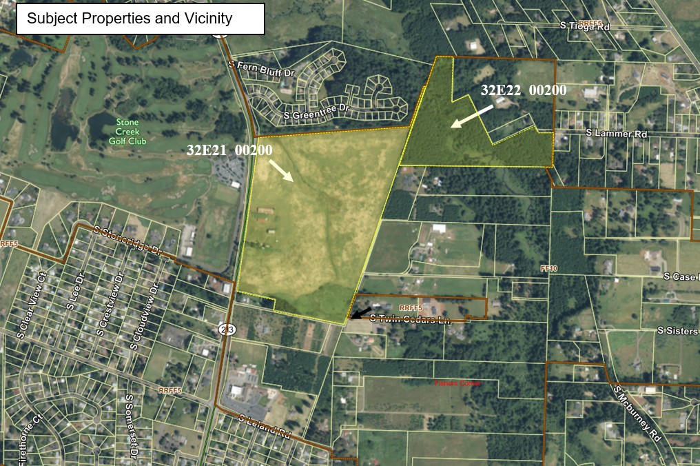
Site Characteristics: The larger tax lot 32E21 00200 (approximately 82.7 acres) has gently sloping topography, with the highest elevations in the southwestern portions of the property. The property has been managed primarily as agricultural grass seed/hay production and livestock. Historical photos from 1952 to 2020 show very little change on site. A single family home, a barn, and several outbuildings are located in the west-central portion of the site.
The smaller taxlot 32E22 00200 (approximately 29.3 acres) is undeveloped and appears to be primarily forested. This taxlot is divided by a canyon, through which Beaver Creek runs. Slopes in excess of 20% are present on this property, generally along Beaver Creek.
Streams, wetlands, and other habitat areas: A linear riverine wetland (per the Department of State Lands classification) runs north through the central portion of the larger tax lot (32E21 00200). The applicant’s submitted wetland delineation determined that there were additional wetlands associated with this mapped riverine wetland; per this report, the total acreage of wetlands on tax lot 32E21 00200 is 0.89 acres.
As noted, the smaller taxlot (32E22 0200) is divided by Beaver Creek. Beaver Creek is classified by the state and the U.S Fish and Wildlife Service as freshwater forested shrub wetland. A wetland delineation was not prepared for this lot however, this segment of Beaver Creek is a regulated River and Stream Conservation Area, per the County maps.
There are no other known wetlands, streams or other protected resource or habitat areas on the properties. There are no regulated hazard areas (floodplain, mass movement areas, etc.) on the properties.
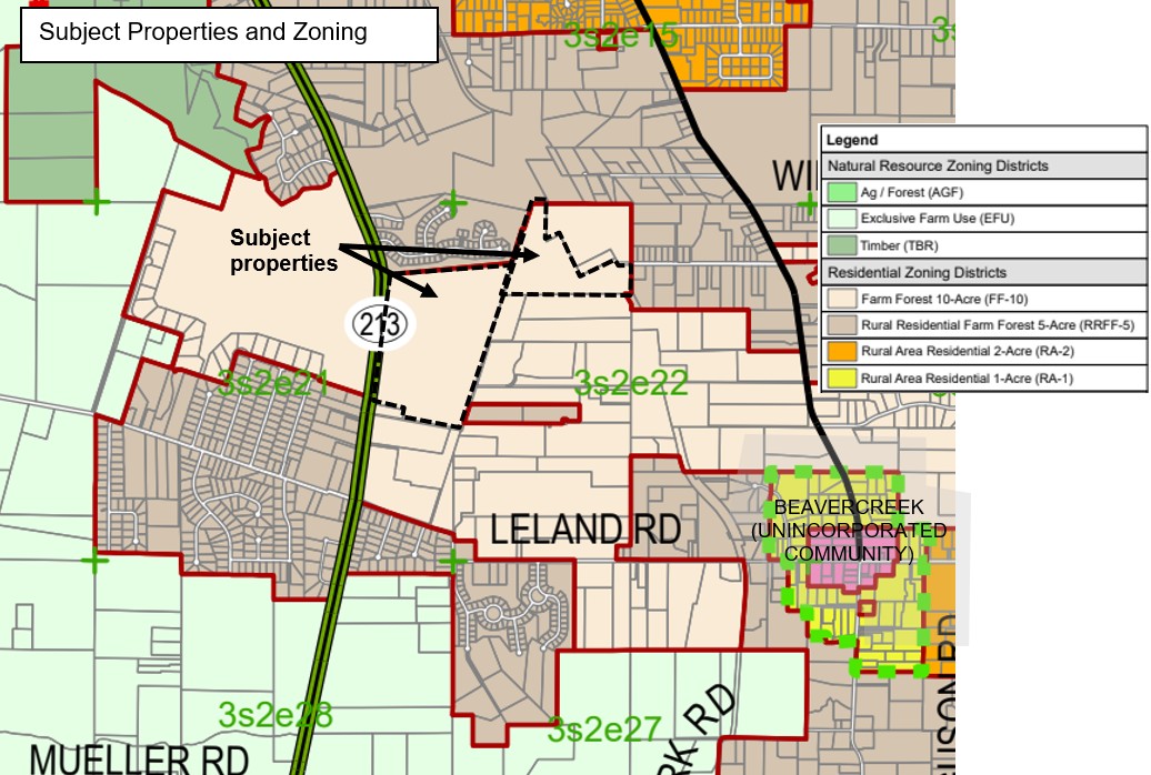
Subject Properties and Zoning (Source: Clackamas County, Non-Urban Area Zoning map)
Service providers:
- Sewer: The subject properties are not located within a public or private sewer district. On-site wastewater systems would be required for any future development.
- Water: The subject properties are located within Clackamas River Water service district.
- Fire Protection: Clackamas RFPD #1
Noticing: This application has been processed consistent with the legal noticing requirements in Section 1307, Procedures, of the County’s Zoning and Development Ordinance (ZDO) and with state noticing requirements. Specifically, the County has provided notice to interested agencies, local governments and property owners within 2,650 feet of the subject property consistent with State law and Section 1307 of the ZDO. The notification to property owners, public notices and hearings ensures an opportunity for citizens to participate in the land use process.
Responses received: To date, Staff have received nine (9) comment letters or emails (see Exhibits 3 through 11).
Agency comments: The Department of Land Conservation and Development (DLCD) is the only agency that submitted comments. In their comments, DLCD opposes the proposed Goal 14 exception, noting that they are not convinced that the applicable criteria have been met. The letter asserts that:
- The smaller-lot residential development that exists near the subject site occurred prior to Oregon’s current land use scheme and do not commit the subject to the same type of development;
- Approving the proposal would conflict with the purpose and function of the Metro urban growth boundary (UGB) in Oregon City; and
- They find the applicants’ analysis of the surrounding lands to be in error and disagree that that the development pattern in the area has made it impracticable to develop the subject site with the 10-acre rural residential lots allowed under the site’s current zoning.
DLCD’s letter also questions whether a Goal 11 exception would also be needed for the proposal, particularly for the extension of public water service.
Public comments: All eight comment letters or emails from the members of public were in opposition to the proposed zone change. Major issues raised included traffic congestion and safety along S Highway 213; potential negative environmental impacts to Beaver Creek, wetlands and wildlife habitat; loss of farmland; rural conflicts; and other concerns related to quality of life. Although several did express opposition generally to urbanization within the rural community, none directly addressed any of the criteria relevant to the proposal for an exception to statewide Planning Goal 14. As noted previously, the county Hearing’s Officer already determined the zone change criteria, including consideration for traffic impacts and impacts to wetlands and natural areas have already been met, provided the applicant meets the conditions of approval related to these items.
Public Hearings:
Two public hearings on the current proposal are scheduled: one before the Planning Commission on August 10, 2026, and another before the Board of County Commissioners (Board) on September 22, 2026. The Planning Commission makes a recommendation to the Board, who will ultimately decide whether the proposal is approved.
III. Findings: Assignments of Error Addressed (LUBA 2023-078)
In their decision regarding the appeal of file no. Z0277-23, LUBA discusses two assignments of error, summarized below (see Exhibit 2 for complete decision).
First Assignment of Error: In this Assignment of Error, LUBA found that the county had improperly construed OAR 660-004-0040 when the hearings officer concluded that the rule does not require an exception to Goal 14 for the unzoning that the applicant seeks for the subject property. The meaning of the Rule and the Rule history were the subject of much of LUBAs discussion, leading to their conclusion that it “seems clear…LCDC intended that Upzoning be accomplished only in conjunction with a Goal 14 exception”(p.30 LUBA). The Oregon Court of appeals upheld this determination.
Because the courts found that OAR 660-004-0040(7) requires a Goal 14 exception for the rural residential upzoning in file no. Z0277-23 and none was included in that file, the decision was remanded on this issue.
Second Assignment of Error: In this Assignment of Error, the petitioner argued that even if OAR 660-004-0040(7) does not require an exception to Goal 14, the application would require a Goal 14 exception because it an urban use of rural land in violation of Goal 14. Because LUBA sustained the First Assignment of Error, the Second Assignment of Error was not addressed, as it would be resolved by the required exception to Goal 14.
The applicant provides a discussion about the appeal and LUBA’s direction on remand on page 7 of the application narrative (Exhibit 1). The applicant states, and staff agrees, that “at least one of the problems with applying OAR 660-004-0040(7) to Application is that it paradoxically requires a Goal 14 exception (i.e. an exception for “urban levels of development”) for lands that are now and will explicitly remain rural under the Comprehensive Plan and under applicable zoning.” Nonetheless, to address the remand, the applicant has provided an application for an exception to statewide Planning Goal 14, Urbanization, so that the previously-approved zone change can move forward.
A. Goal Exception: Oregon Revised Statutes (ORSs) and Oregon Administrative Rules (OARs)
The subject property is designated as Rural (R) on the Comprehensive Plan Map. Per the Comprehensive Plan, Rural lands are exception lands, as defined in Oregon Administrative Rules 660-004-0005(1), that are outside urban growth boundaries and Unincorporated Communities and are suitable for sparse settlement, such as small farms, woodlots, or acreage home sites. They lack public facilities or have limited facilities and are not suitable, necessary, or intended for urban, agricultural, or forest use.
Three distinct zoning districts implement the Rural (R) Plan designation: Farm Forest, 10-acre (FF-10), Rural Residential Farm Forest, 5-acre (RRFF-5) and Rural Area Residential, 2-acre (RA-2). All three of these zoning districts are considered to be “rural residential” zones; none are agricultural districts under state law.
OAR 660-004-0040 implements Statewide Planning Goal 14 and sets standards for lot sizes in rural residential zones. It partially codifies a court ruling that determined development on lots smaller than two acres was “urban development” and not allowed outside urban growth boundaries or an acknowledged unincorporated communities without taking an exception to Goal 14. OAR 660-004-0040 also identifies considerations and requirements for zone changes within rural residential areas.
Despite the fact that the Plan designation is not changing, LUBA and the Court of Appeals’ decisions determined that the specific language in OAR 660-004-0040(7) requires the applicant obtain an exception to Goal 14, Urbanization, for the requested zone change because it would allow a smaller average lot size than the current zoning. The OARs do not, however, provide clear direction on consideration of an exception to Goal 14 for a rural residential use (rather than an urban use).
Goal exceptions, generally, are amendments to comprehensive plan provisions that set forth facts and reasons authorizing and justifying the necessary departures from the goals. Goal exceptions are authorized under statewide planning statutes, goals and administrative rules in order to provide flexibility for situations in which a departure from the strict application of the goals is justified based on site-specific and project specific conditions. Approval of a goal exception does not establish precedent for allowing future goal exceptions. Goal 2 defines the term "exception" as follows:
"Exception means a comprehensive plan provision, including an amendment to an acknowledged comprehensive plan, that:
"(a) Is applicable to specific properties or situations and does not establish a planning or zoning policy of general applicability;
"(b) Does not comply with some or all goal requirements applicable to the subject properties or situations; and
"(c) Complies with standards for an exception."
There are three types of goal exceptions: (1) "physically developed" exceptions are justified where the property is physically developed to the extent that it is no longer available for uses allowed by the applicable goal; (2) "irrevocably committed" exceptions are justified where existing adjacent uses and other relevant factors make uses allowed by the applicable goal impracticable; and (3) "reasons" exceptions are justified where there is a need for development at the site in question and where the applicant establishes that reasons justify why the policy embodied in the applicable goals should not apply, the proposed development cannot reasonable locate elsewhere, and the proposed use is compatible with other adjacent uses or can be made compatible through measures designed to reduce impacts. This application is for an “irrevocably committed” exception.
The applicant asks the county to consider this goal exception under one of two scenarios:
- If the county maintains its position that the property will remain “rural” both before and after the proposed amendment, the county could interpret “urban levels of development” in this context to mean that rural residential parcels are moving from one end of the spectrum of minimum lot size zones to the other, while remaining “rural” in character, or
- If the county no longer finds that the property will remain “rural” even with a two acre minimum lot size, the proposed new designation would be considered an “urban” use.
Since no new evidence has been submitted that would lead staff to a different determination than was made by the Hearing’s Officer in file no. Z0277-23, namely that the proposed two-acre lots in the RA-2 zone would not convert allowable residential uses from rural to urban uses, it is therefore assumed that, if file nos. Z0182-26 and Z0277-23 are approved, the uses on the site would remain rural.
Staff have reviewed the applicable criteria for an exception to Goal 14 and the applicant’s preliminary findings in conjunction with this proposal. Compliance with the applicable regulations found in each is discussed below.
“Irrevocably Committed” Exception to SWP Goal 14, Urbanization
This application requests an "irrevocably committed" exception to Goal 14. The general criteria for such an exception are set forth in the state statutes at ORS 197.732 and LCDC's administrative rules at OAR 660-004-0018 and OAR 660-004-0028. For an exception to Goal 14 to allow urban development on rural lands, as is contemplated in this proposal, OAR 660-014-0030 or 660-014-0040, are also applicable.
ORS 197.732 - Goal Exceptions. ORS 197.732(2)(b) sets forth the following criteria for a goal exception based on a “irrevocable committed” argument, as follows:
The land subject to the exception is irrevocably committed as described by Land Conservation and Development Commission rule to uses not allowed by the applicable goal because existing adjacent uses and other relevant factors make uses allowed by the applicable goal impracticable.
In the case of the subject property, to demonstrate that an “irrevocably committed” exception is warranted, it must be demonstrated that uses allowed under Goal 14 and the site’s existing zoning designation (FF-10) are made impracticable by the existing adjacent uses and other relevant factors. As is detailed through the findings below, staff finds that the applicant has failed to demonstrate how or why the adjacent uses and other factors make the development of up to 11 rural residential lots impracticable and therefore ORS 197.732 (2)(b) is not met.
(4) A local government approving or denying a proposed exception shall set forth findings of fact and a statement of reasons that demonstrate that the standards of subsection (2) of this section have or have not been met.
This report sets forth the findings of fact that demonstrate the standards of subsection (2) have not been met.
OAR 660-004-0000 through 0010. Purpose, Definitions, and Application of Goal 2 Exceptions Process to Certain Goals
These sections contain the background information and definitions for the goal exception and are information in nature. OAR 660-004-0010(1)(d)(D) specifies that [f]or an exception to Goal 14 to allow urban development on rural lands, a local government must follow the applicable requirements of OAR 660-014-0030 or 660-014-0040, in conjunction with applicable requirements of this division. OAR 660-014-0030 contains the relevant criteria for an “irrevocable committed” exception and is addressed below. OAR 660-014-0040 contains relevant criteria for a “reasons’ exception to Goal 14, which is not proposed and therefore not addressed.
660-014-0030: Rural Lands Irrevocably Committed to Urban Levels of Development
(1) A conclusion, supported by reasons and facts, that rural land is irrevocably committed to urban levels of development can satisfy the Goal 2 exceptions standard (e.g., that it is not appropriate to apply Goals 14’s requirement prohibiting the establishment of urban uses on rural lands). If a conclusion that land is irrevocably committed to urban levels of development is supported, the four factors in Goal 2 and OAR 660-004-0020(2) need not be addressed.
This criterion is informational and references four factors related to the “reasons” exception. If it is found that the subject site is irrevocably committed to urban levels of development, then the identified criteria do not need to be addressed.
(2) A decision that land has been built upon at urban densities or irrevocably committed to an urban level of development depends on the situation at the specific site. The exact nature and extent of the areas found to be irrevocably committed to urban levels of development shall be clearly set forth in the justification for the exception. The area proposed as land that is built upon at urban densities or irrevocably committed to an urban level of development must be shown on a map or otherwise described and keyed to the appropriate findings of fact.
The nature and extent of the area the applicant asserts are subject to the “irrevocable commitment” are identified in both the application narrative and attached maps. If the goal exception is found to be warranted, this criterion is met. This criterion can be met.
(3) A decision that land is committed to urban levels of development shall be based on findings of fact, supported by substantial evidence in the record of the local proceeding, that address the following:
(a) Size and extent of commercial and industrial uses;
(b) Location, number and density of residential dwellings;
(c) Location of urban levels of facilities and services; including at least public water and sewer facilities; and
(d) Parcel sizes and ownership patterns.
Commercial and industrial uses: The applicant identifies several commercial uses in the area of the subject but suggests the golf course across the highway to the west is a commercial use. The golf course is not considered a commercial use; rather it is an allowed recreational use in the rural area. The veterinary clinic and the distillery located approx. ¼-mile south of the subject site and identified in the application are commercial uses and were approved as allowed rural commercial uses, supporting the local agricultural community. No industrial uses were identified in the area.
Location, number and density of residential dwellings: The application includes an analysis of parcels and development within one mile of the subject site, finding that 85% of the parcels in this area are smaller than 2 acres. The applicant further notes that “existing single family subdivisions are located to the north, south, west and southwest and have typical lot sizes of 8,000 to 20,000 square feet.” After some discussion, the applicant concludes that the surrounding area is “at the more urbanized end of the scale of rural residential uses on lands designated as rural under the Comprehensive Plan” and that “because the property is situated within a rural area that is characterized by urban levels of use…the property is likewise committed to similar urban levels of use”. (see pages 12-13 of application narrative, Exhibit 1).
Elsewhere in the application, the applicant also characterizes the site as “almost completely surrounded by rural residential lot with urban levels of development”.
Staff disagrees with the applicant’s assertions and conclusion for a number of reasons:
- There are indeed a number of smaller- lot rural residential subdivisions in the vicinity of the subject site – and one immediately adjacent to the north. Lots in these subdivisions do range from 8,000 to 20,000 square feet (approximately ½-acre) in size. These subdivision lots, however, were established primarily in the late 1960’s and early 1970s, prior to the current zoning designations. The only new residential lots of under two acres that have been developed since the 1970s are the lots around Stone Creek Golf Course, which were approved in 1990 as a planned unit development, which allowed for smaller lot sizes in exchange for retaining a large open space (i.e. the golf course). Despite the presence of some smaller-lot residential development in the area, there is no evidence presented demonstrating that these lots – primarily developed more than five decades ago – somehow commit other nearby lots to developing at similar densities. The fact that only one new smaller-lot residential development has occurred over those five-plus decades, reiterates this conclusion.
Only one of the identified smaller-lot subdivisions is directly adjacent to the subject site - to the north. That subdivision does contain small rural-zoned lots that, under Goal 14 would be considered “urban” due to their size of under 2 acres. The vast majority of the other adjacent development is actually on lots that range from 5 to 20 acres, which would not be considered urban development (see maps in Exhibit 2).
In their comment letter, DLCD notes this as well, stating that “The applicant’s analysis also does not acknowledge that the subject property is bordered on almost the entire southern, eastern, and part of the northern boundary by parcels of five acres or larger, including parcels of 34 acres, 21 acres, 13 acres, 5 acres, 8.88 acres, 10.64 acres, and 10.87 acres. This pattern reflects a predominantly rural landscape. We do not believe the area exhibits the characteristics of land irrevocably committed to a two-acre residential development pattern. Staff concurs with DLCD on this point.
The applicant relies on an analysis of residential development within one mile of the subject site. Staff finds two issues with this analysis. First, state law require a determination of how “adjacent uses and other relevant factors” create the “irrevocable commitment”; development one mile away is far from “adjacent”. Second, in assessing properties as far as a mile away, the applicant includes urban lots within the Metro urban growth boundary (UGB) in this analysis. Including properties inside the UGB to establish a commitment outside the UGB, while at the same time arguing that the subject site’s proximity to the UGB does not conflict with the UGB’s ability to function (see HO decision, Exhibit 2) is inconsistent.
In addition, as noted by DLCD, “Including these urban, and semi urban parcels in the data set does not reflect the rural land use pattern and results in a parcel size distribution that skews the analysis toward a more urbanized pattern that does not apply to the subject area.”
- And finally, even though there may be development in the vicinity of the subject site that, under Goal 14, is considered “urban” or “urban-type”, the applicant has not demonstrated how or why this other development renders the subject site “irrevocably committed” to smaller residential lots. In other words, the applicant has not demonstrated how or why adjacent development pattern makes the development of up to 11 rural residential lots impracticable, particularly give the preponderance or rural residential development on lots larger than 2 acres directly adjacent to the southern and eastern boundaries of the subject sites.
Urban level of facilities: Public sewer is not available or needed for the proposed two-acre lots. In file no. Z0277-23, the applicant demonstrated that although public water is available from Clackamas River Water (CRW), it is not necessary for the proposed development of two-acre lots because they could be developed on private wells.
In the Goal 14 exception the applicant seems to contradict this finding by relying on the fact that public water is available to demonstrate that the area is committed to urban uses.
Parcel sizes and ownership pattern: Here, the applicant reiterates that the site is “almost completely surrounded by rural residential uses with urban levels of development” but then states that the property is “almost completely surrounded by residential lots, nearly all of which are smaller than 10 acres and range from 2+ to 5+ acres.” As noted above, this latter statement is more accurate description of the properties adjacent to the subject site.
In their letter, DLCD also notes that “the applicant’s analysis relies heavily on the number of parcels in the surrounding area. The reliance on the number of parcels skews the analysis and ignores the acreages involved. The analysis of surrounding development patterns should be based on total acreage, to give a more balanced look at the surroundings. The applicant states that the surrounding 1-mile radius area is composed of 1,883 parcels and that only 8% of these parcels are larger than five acres. However, the total acreage of the parcels that fall in the 1-mile radius is approximately 3500 to 4000 acres, based on a rough measurement, and that more than half of that acreage approximately 2,180 acres, is made up of properties 10 acres or larger.”
Ownership patterns were not discussed in the application.
Based on the above, staff finds that evidence in the record does not support a conclusion that the subject site is “irrevocably committed” to urban levels of development. Staff finds no evidence in the record that the surrounding pattern of development, adjacent uses, or other factors render the development of up to 11 rural residential lots on the subject site impracticable.
This criterion is not met.
(4) A conclusion that rural land is irrevocably committed to urban development shall be based on all of the factors listed in section (3) of this rule. The conclusion shall be supported by a statement of reasons explaining why the facts found support the conclusion that the land in question is committed to urban uses and urban level development rather than a rural level of development.
Per state law, the standard for “irrevocably committed” is that the land subject to the exception be “irrevocable committed” to uses not allowed by the applicable goal because existing adjacent uses and other relevant factors make uses allowed by the applicable goal impracticable” (ORS 197.732) In the case of the subject property, to demonstrate an “irrevocably committed” exception is warranted, it must be demonstrated that uses allowed under Goal 14 and the site’s existing zoning designation (FF-10) are made impracticable by the existing adjacent uses and other relevant factors.
Although the applicant provided a statement of reasons to address this criterion, staff does not concur with the applicant’s assertion that the existing development pattern and usage in the area of the subject has created an “irrevocable commitment” on the subject site. Staff finds that the applicant provided no evidence that developing the site with up to 11 rural residential lots, as would be allowed under the current zoning, is impracticable.
This criterion is not met.
(5) More detailed findings and reasons must be provided to demonstrate that land is committed to urban development than would be required if the land is currently built upon at urban densities.
Staff finds that the applicant did provide detailed findings but failed to demonstrate that the subject site is committed to urban development.
This criterion is not met.
OAR 660-004-0018, Planning and Zoning for Exception Areas
(2) For "physically developed" and "irrevocably committed" exceptions to goals, residential plan and zone designations shall authorize a single numeric minimum lot size and all plan and zone designations shall limit uses, density, and public facilities and services to those that satisfy (a) or (b) or (c) and, if applicable, (d):
(a) That are the same as the existing land uses on the exception site;
(b) That meet the following requirements:
(A) The rural uses, density, and public facilities and services will maintain the land as "Rural Land" as defined by the goals, and are consistent with all other applicable goal requirements;
(B) The rural uses, density, and public facilities and services will not commit adjacent or nearby resource land to uses not allowed by the applicable goal as described in OAR 660-004-0028; and
(C) The rural uses, density, and public facilities and services are compatible with adjacent or nearby resource uses;
(c) For uses in unincorporated communities, the uses are consistent with OAR 660-022-0030, "Planning and Zoning of Unincorporated Communities", if the county chooses to designate the community under the applicable provisions of OAR chapter 660, division 22;
(d) For industrial development uses and accessory uses subordinate to the industrial development, the industrial uses may occur in buildings of any size and type provided the exception area was planned and zoned for industrial use on January 1, 2004, subject to the territorial limits and other requirements of ORS 197.713 and 197.714.
Staff finds that this criterion perplexing in the context of a Goal 14 exception for urban uses on rural lands - because it does not contemplate uses that would be allowed if it is actually established that a property is committed to urban uses. However, in the context of the Goal 14 exception under the first scenario presented by the applicant, namely that the “urban” use is simply a smaller-lot rural residential development, this criterion can be addressed. The applicant addresses this criterion by noting that the proposed zoning district – RA-2 – is an acknowledged rural zoning district that allows rural levels of development.
In addition, detailed findings that determined the proposed RA-2 zoning would retain the land in a “rural” use were included in the HO decision for file no. Z0277-23. As noted earlier, no additional evidence has been provided that would warrant a different determination.
This criterion is met.
660-004-0028, Exception Requirements for Land Irrevocably Committed to Other Uses
(1) A local government may adopt an exception to a goal when the land subject to the exception is irrevocably committed to uses not allowed by the applicable goal because existing adjacent uses and other relevant factors make uses allowed by the applicable goal impracticable:
(a) A "committed exception" is an exception taken in accordance with ORS 197.732(2)(b), Goal 2, Part II(b), and with the provisions of this rule, except where other rules apply as described in OAR 660-004-0000(1).
(b) For the purposes of this rule, an "exception area" is that area of land for which a "committed exception" is taken.
(c) An "applicable goal," as used in this rule, is a statewide planning goal or goal requirement that would apply to the exception area if an exception were not taken.
This criterion is informational and provides definitions relevant in the assessment of an irrevocably committed exception.
(2) Whether land is irrevocably committed depends on the relationship between the exception area and the lands adjacent to it. The findings for a committed exception therefore must address the following:
(a) The characteristics of the exception area;
(b) The characteristics of the adjacent lands;
(c) The relationship between the exception area and the lands adjacent to it; and
(d) The other relevant factors set forth in OAR 660-004-0028(6).
The applicant identifies the characteristics of the proposed exception area (subject site) as well as adjacent lands, but as noted above, does not explain the relationship between the subject site and the lands adjacent to it and how those adjacent lands might commit the subject site to uses not allowed under the current zoning.
This criterion is not met.
(3) Whether uses or activities allowed by an applicable goal are impracticable as that term is used in ORS 197.732(2)(b), in Goal 2, Part II(b), and in this rule shall be determined through consideration of factors set forth in this rule, except where other rules apply as described in OAR 660-004-0000(1). Compliance with this rule shall constitute compliance with the requirements of Goal 2, Part II. It is the purpose of this rule to permit irrevocably committed exceptions where justified so as to provide flexibility in the application of broad resource protection goals. It shall not be required that local governments demonstrate that every use allowed by the applicable goal is "impossible." For exceptions to Goals 3 or 4, local governments are required to demonstrate that only the following uses or activities are impracticable:
(a) Farm use as defined in ORS 215.203;
(b) Propagation or harvesting of a forest product as specified in OAR 660-033-0120; and
(c) Forest operations or forest practices as specified in OAR 660-006-0025(2)(a).
To address this criterion, it is important to first understand what must be considered “impracticable”. For an exception under these Rules, the evidence must reasonably lead to a conclusion that uses allowed under the current FF-10 zoning (which is compliant with Goal 14) are impracticable on the subject with consideration for circumstances on the subject site itself and the relationship of the site to adjacent lands. In this case those uses would be one single-family dwelling, and possibly one accessory dwelling unit, per lot. The property size and zoning regulations would potentially allow for the subject site to be divided into 11 lots for such development.
In their comment, the Department of Land Conservation and Development (DLCD) outlines several reasons that this application fails to meet the standard needed to demonstrate that the subject property is irrevocably committed to urban uses. See Exhibit 4. Although Staff does not agree with the entirety of DLCD’s assessment, staff does concur with the conclusion that the standard for an “irrevocable commitment” has not been met in this case for the following reasons:
- The applicant’s submitted materials do not provide evidence that such a development is impracticable. Rather the applicant asserts that because there exists smaller lot residential development in the vicinity of the subject sites, that fact “commits’ the subject site to also developing with smaller lots.
- Lots immediately adjacent to the subject site on the south, east, and northeast are predominantly larger rural residential lots, many of which are larger than five acres.
- Residential development in the larger vicinity has changed very little since the 1970s and the subsequent imposition of the current zoning scheme, indicating that the smaller rural residential lots in the area have not committed any nearby properties to similar development and that nearby properties are being developed consistent with the current rural zoning.
This criterion is not met.
(4) A conclusion that an exception area is irrevocably committed shall be supported by findings of fact that address all applicable factors of section (6) of this rule and by a statement of reasons explaining why the facts support the conclusion that uses allowed by the applicable goal are impracticable in the exception area.
(6) Findings of fact for a committed exception shall address the following factors:
(a) Existing adjacent uses;
(b) Existing public facilities and services (water and sewer lines, etc.);
(c) Parcel size and ownership patterns of the exception area and adjacent lands:
(A) Consideration of parcel size and ownership patterns under subsection (6)(c) of this rule shall include an analysis of how the existing development pattern came about and whether findings against the goals were made at the time of partitioning or subdivision. Past land divisions made without application of the goals do not in themselves demonstrate irrevocable commitment of the exception area. Only if development (e.g., physical improvements such as roads and underground facilities) on the resulting parcels or other factors makes unsuitable their resource use or the resource use of nearby lands can the parcels be considered to be irrevocably committed. Resource and nonresource parcels created and uses approved pursuant to the applicable goals shall not be used to justify a committed exception. For example, the presence of several parcels created for nonfarm dwellings or an intensive commercial agricultural operation under the provisions of an exclusive farm use zone cannot be used to justify a committed exception for the subject parcels or land adjoining those parcels.
(B) Existing parcel sizes and contiguous ownerships shall be considered together in relation to the land's actual use. For example, several contiguous undeveloped parcels (including parcels separated only by a road or highway) under one ownership shall be considered as one farm or forest operation. The mere fact that small parcels exist does not in itself constitute irrevocable commitment. Small parcels in separate ownerships are more likely to be irrevocably committed if the parcels are developed, clustered in a large group or clustered around a road designed to serve these parcels. Small parcels in separate ownerships are not likely to be irrevocably committed if they stand alone amidst larger farm or forest operations, or are buffered from such operations;
(d) Neighborhood and regional characteristics;
(e) Natural or man-made features or other impediments separating the exception area from adjacent resource land. Such features or impediments include but are not limited to roads, watercourses, utility lines, easements, or rights-of-way that effectively impede practicable resource use of all or part of the exception area;
(f) Physical development according to OAR 660-004-0025; and
(g) Other relevant factors.
These criteria are largely redundant with the criteria in OAR 660-014-0030 (addressed above). As noted above, the applicant provides analysis to address these criteria, but after consideration of the factors, staff finds that the proposal does not meet the standards for an “irrevocably committed” exception for a number of reasons.
- Most notably perhaps, is that although small parcels do exist within the nearby exception area, (c)(A) clearly states that this parcel size alone is not enough to constitute an irrevocable commitment: “The mere fact that small parcels exist does not in itself constitute irrevocable commitment.” The applicant has not demonstrated that physical development or uses on nearby small parcels have rendered the subject site unsuitable for the rural residential uses allowed on the subject site.
- Residential development in the larger vicinity has changed very little since the 1970s and the subsequent imposition of the current zoning scheme, indicating that the smaller rural residential lots in the area have not committed any nearby properties to similar development and that nearby properties are being developed consistent with the current rural zoning.
- “Commercial” uses cited in the application that are located nearby were approved under the current rural zoning and are either (1) recreational and not commercial, or (2) commercial uses that were approved to support the local agricultural community. None of these uses are considered “urban” uses.
- No information was provided by the applicant about ownership patterns, nor about any uses that may exist on these parcels that were not approved pursuant to the applicable goals at the time the use were approved.
- Similarly, the applicant has not demonstrated that physical development on nearby parcels has rendered the subject site unsuitable for the rural residential uses allowed on the subject site.
- Public sewer is not available at or near the subject site. Public water is available from Clackamas River Water (CRW), which provides water service to a large service area, both inside and outside the Metro urban growth boundary (UGB). In file no. Z0277-23, the Hearing’s Officer found that simply because the water is available does not make the proposed RA-2 use “urban”. Similarly, staff finds that access to public water does not “commit” the site to urban uses.
- The subject site is largely vacant; the only physical development on the site is a single family dwelling and associated accessory structures.
- No other relevant factors were identified by the applicant.
This criterion is not met.
(7) The evidence submitted to support any committed exception shall, at a minimum, include a current map or aerial photograph that shows the exception area and adjoining lands, and any other means needed to convey information about the factors set forth in this rule. For example, a local government may use tables, charts, summaries, or narratives to supplement the maps or photos. The applicable factors set forth in section (6) of this rule shall be shown on the map or aerial photograph.
The applicant provided maps and other information including a narrative (Exhibit 1) and Staff included additional information (Exhibit 2), which sufficiently conveys the applicable factors set forth in the Rule.
This criterion is met.
SUMMARY: Based on the above analysis and findings, Staff finds that the proposal does not meet the required criteria for an irrevocable committed exception to Statewide Planning Goal 14.
B. Statewide Planning Goals
Goal 2 – land use planning
Goal 2 requires the County to have and to follow a comprehensive land use plan and implementing regulations. Comprehensive plan provisions and regulations must be consistent with Statewide Planning Goals, but Goal 2 also provides a process by which exceptions can be made to certain Goals.
This proposed goal exception and amendment to the County’s Comprehensive Plan would not change the County’s land use planning process. However, this Goal also requires a jurisdiction’s Comprehensive Plan provisions and land use regulations to be consistent with the Statewide Planning Goals. This report outlines how this proposal is not consistent with:
- Statewide Planning Goal 14; and
- Criteria for the required exception to Statewide Planning 14.
Statewide Planning Goal 2 is not satisfied.
Goal 14 – urbanization
The purpose of Goal 14 is to provide for an orderly and efficient transition from rural to urban land use, to accommodate urban population and urban employment inside urban growth boundaries, to ensure efficient use of land, and to provide for livable communities.
The application does not propose to expand or modify any UGB or to permit rural land uses inside the UGB. However, as noted previously, OAR 660-004-0040, Application of Goal 14 to Rural Residential Areas, contains direction for how Goal 14 specifically applies to rural lands and LUBA and the Court of Appeals determined that for a proposal to create smaller rural residential lots like is proposed, an exception to Goal 14 must be taken. To address this, the applicant has proposed an “irrevocably committed” exception to Goal 14.
Based on the above analysis and findings, Staff finds that the proposal does not meet the required criteria for an irrevocable committed exception to Statewide Planning Goal 14.
Statewide Planning Goal 14 is not satisfied.
C. Clackamas County Comprehensive Plan (Plan) and Zoning & Development Ordinance (ZDO)
The only Comprehensive Plan policies and provisions in the county’s Zoning & Development Ordinance (ZDO) relevant to the Goal exception application are procedural. This application has been processed consistent with those procedures. Specifically, the County has provided notice to interested agencies, local governments, and nearby property owners, consistent with state law and ZDO Section 1307, which implements the public notice policies of Chapter 2 of the Comprehensive Plan. Notice to property owners, public notices, and hearings ensure an opportunity for members of the public to participate in the land use process.
Staff notes that there are a number of Comprehensive Plan policies and provisions in the ZDO that are relevant to the zone change from FF-10 to RA-2. Those criteria are discussed in detail in file no. Z0277-23 and the proposed zone has been found to comply with all relevant Comprehensive Plan and ZDO criteria, with the imposition of certain conditions of approval.