
Courtney Ave. Complete Streets

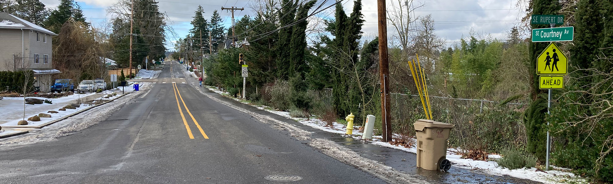
Courtney Ave. is a narrow roadway with bike lanes and no sidewalks which creates potential conflicts between all users.

Status

Project design

Updated: Oct. 8, 2026

The complete streets project will improve safety and accessibility by providing 6-foot separated sidewalks on both sides of Courtney Avenue; 8-foot buffered bike lanes; intermittent rain gardens for stormwater management; street and pedestrian lighting and ADA compliant intersection curb ramps; and crosswalk enhancements at two intersections. The sidewalk and bikeway improvements will also provide a direct east-west connection to the Trolley Trail for travelers.

Why

To improve safety and accessibility for pedestrians and bicyclists with sidewalks and dedicated bike lanes, and an improved link to the Trolley Trail.

Schedule

  • Project planning and design: Sept. 2023 – Spring 2027
  • Right of Way Acquisition Efforts: June 2025 – December 2026 
    All right of way acquisitions are conducted as required by state and federal law. Read right of way brochure: English | Spanish.
  • Construction: Summer 2027 – Fall/Winter 2028 

Traffic impact

  • No impacts to traffic at this time. Rolling single lane closures and detours may be needed during construction.

Current activities

  • Project design 
  • Right-of-way 

Funding

  • Project estimate $8.5 million
  • Funding is provided from the county road funds, transportation system development charges and capital federal funds through a Metro 2022–24 Regional Flexible Fund Allocation Grant and ODOT.

 

County Roads Take Me Home stickerProjects funded through the new Community Road Fund will increase safety, relieve congestion and maintain local roads.
Frequently Asked Questions

127716

The term "complete streets" is typically used for planning and development purposes and is typically associated with transportation elements that include non-vehicle modes of travel such as separated sidewalks and bicycle lanes. Some of the design elements being considered for the Courtney Avenue project include:

  • Construct 6-foot-wide sidewalks and 5.5-foot-wide landscape buffers to create a safer and more comfortable pedestrian environment separated from vehicle traffic. Remove any obstructions in proposed sidewalk areas and add missing ADA compliant curb ramps. The result will be adding approximately 32 ADA compliant curb ramps.
  • Construct 8-foot bicycle lanes (6-foot bike lane with a 2-foot buffer). The existing striped bike lanes function more as shoulders for the roadway than an active transportation facility. The bicycle lanes will also be marked and signed to prevent on-street parking.
  • Enhance the existing crossing at the Courtney Avenue - Trolley Trail intersection with ADA ramps, connecting sidewalks, lighting and a new Rectangular Rapid Flashing Beacon (RRFB) on both the Courtney Avenue at the Trolley Trail approach.
  • Install illumination (streetlights) throughout the limits of the project to increase the visibility of pedestrians and bicyclists.
  • Construct a speed table for the intersection of Linden Lane and Courtney Avenue allowing pedestrians to cross at nearly a constant grade and increasing driver awareness of the intersection and crosswalks. The speed table will be similar to the existing one located at the intersection of Courtney Avenue and Arista Drive/the Trolley Trail.
  • Narrow vehicle travel lanes to 10 feet from the current 12 feet to reduce pedestrian crossing time and to redistribute space to create 2-foot buffers on both sides of the bicycle lanes. Narrowing the lanes is anticipated to reduce traffic speeds and increase driver awareness of their surroundings.
  • In a few locations along the corridor, the vehicle travel lane is immediately adjacent to existing parking lots, creating random access points from the parking areas to Courtney Avenue. The project will work to clearly define parking lot driveway access points to Courtney Avenue.
  • Construct a bike box with ingress lanes on Courtney Avenue on both sides of the intersection of Courtney Avenue and McLoughlin Boulevard. For eastbound travelers, the existing bicycle facility ends approximately 200 feet west of the Courtney Avenue- McLoughlin Boulevard intersection. A bike box will be installed at the southeast corner of this intersection to provide bicyclists with a safe and visible way to get ahead of queuing traffic.
  • Install bicycle detection at McLoughlin Blvd. An infrared video detection camera will be installed on the traffic signal at the Courtney Avenue-McLoughlin Boulevard intersection to detect bikes separately from passenger vehicles. The signal timing will likely be adjusted to help bikes safely cross the wide intersection.
127716

Yes. The plan to improve safety for all travelers was discussed with and supported by community groups that supported the county’s grant request for this project. Removing parking from this narrow section of road is the safest for pedestrians, bicyclists and motorists by removing conflict points. There will be dedicated travel lanes for motorists and bicyclists, and a separated sidewalk for pedestrians.  

As part of the engineering design process, we did look at options to add parking after listening to concerns about limited parking availability along Courtney Ave. from community members at Oak Grove Community Planning Organization meetings and directly with homeowners. Ultimately, we are moving forward without parking spaces. This decision was made because of safety concerns for people biking along this narrow section of road.  

127716

A rain garden is a specialized type of stormwater collection area. Commonly referred to as a stormwater and/or water quality facility, "rain gardens" include plants that are planted in "water quality media". This is a specialized soil mixture that helps clean the stormwater as it both nurtures plant growth, absorbs pollutants, and provides stormwater infiltration before entering storm pipes that lead to adjacent streams.

127716

A raised speed table is a traffic calming or traffic safety element similar to a speed bump, but at or near the same height as the adjacent sidewalks.

127716

Staff have been monitoring the intersection for some time. A review of the pending project design alternatives will occur at this intersection and the remainder of the overall design. Concerning the signal itself, we have discussed and are considering removing the overhead flasher and hanging lights. Traffic signal flasher poles on top of stop signs, advanced warnings signs and light poles are being considered.

127716

The grant obtained to implement the project includes defined project limits between River Road and McLoughlin Road. These limits were chosen to balance the total project costs with previous grant awards. Extending the project limits is not an option for this project. 

127716

Yes. After further consideration of the design alternatives, the project scope will include widening and adjusting the travel lanes, including the bike lanes and sidewalks, and repaving the roadway by removing the existing asphalt and paving over it. There should not be a noticeable elevation difference between the road and adjoining properties. 

127716
Contact
Department Staff
Bob Knorr
Project Manager
503-742-4680

Phone:503-742-4691
Email:engineering@clackamas.us

150 Beavercreek Road Room #325 Oregon City, OR 97045

Office Hours:

Monday to Thursday
8 a.m. to 4 p.m.

Available by phone/email
Friday
8 a.m. to 3 p.m.

Related News
Transportation Engineering, Board of County Commissioners, Transportation and Development