Code Amendments to Protect Natural Resources in Housing Development

To comply with state law, Clackamas County must amend the county code related to natural resources and natural hazard areas to meet new standards for development, including housing.  

As we review and amend our zoning code to have a clear and objective pathway for housing development, it will create clear and objective pathways for all development.

These new “clear and objective standards” are now required for nearly every type of land use regulation that applies to housing development. 

Clear and objective standards are terms, definitions and measurements that provide for consistent interpretation of a regulation. In other words, any two people applying the same standard to a development would get the same result. If a rule is clear and objective, then there is no need for a land use reviewer to use their discretion in interpreting the standard. 

Meeting the goal for clear and objective standards will provide ease of use and efficiency for the development community and for staff supporting development in Clackamas County.   

Join a town hall 

If you'd like to learn more about these proposed land use changes, join us at a town hall. Staff will provide a presentation then open for questions from the audience. 

Provide feedback online by Dec. 15

Another way to learn more about the land use focus areas and ways the regulations might change to be more clear, and to provide feedback is through our virtual environment for engagement. Provide input through Tuesday, Dec. 15, 2026.

Project schedule

The four major milestones of this project include:

  1. June – Oct. 2025 | Code audit and concepts: A consultant will identify update needs summarized in an audit with initial recommendations. The Planning Commission reviewed and commented on the audit in November, and December 2025. The Board of County Commissioners provided direction on the policy questions highlighted by the audit in March 2026.
  2. Nov 2025 – April 2026 | Initial draft code updates:A first draft of the code amendments will be completed based on the findings and initial recommendations from the audit, initial input from the Planning Commission, and direction from the Board of County Commissioners. The Planning Commission will review and comment in Fall 2026.
  3. May – Dec. 2026 | Revised code updates: Based on feedback from the Planning Commission, stakeholder and community input, a revised set of code amendments will be provided to the Planning Commission for a second round of review.
  4. Jan. 2026 – April 2027 | Adoption: Finalize code updates and prepare for adoption, scheduled for spring 2027. 
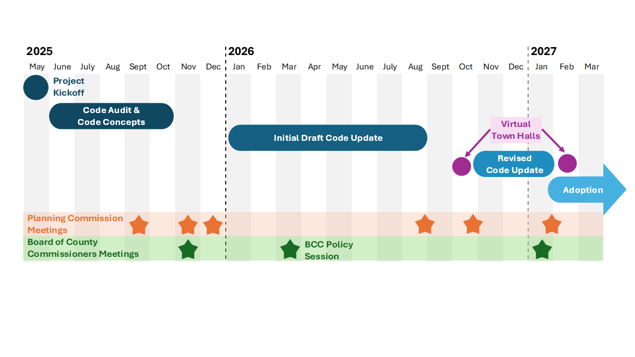
Timeline visualizing the schedule for this project

Applicable sections of code 

Updates to other code chapters may be identified through the process. This project intends to avoid updates to the mapped inventories and changes to the level of protection from development. Rather, the code updates aim to clarify the existing regulations that apply to the resource inventories for the purposes of meeting the state’s clear and objective requirements for housing.

  1. River and Stream Conservation Areas (RSCA – ZDO 704) – Areas adjacent to rivers and streams intended to protect water quality and river habitat outside the Urban Growth Boundary. .
  2. Willamette River greenway (WRG – ZDO 705): Areas adjacent to the Willamette River intended to protect water quality and habitat.
  3. Habitat conservation area districts (HCA – ZDO 706): Mapped wetlands, riparian corridors and wildlife habitat inside the Urban Growth Boundary.
  4. Water quality resource areas (WQRA – ZDO 709): Mapped wetland and riparian corridors inside the Urban Growth Boundary.
  5. Protection of natural features (ZDO 1002): Mapped areas of natural resources and natural hazards including hillsides, open spaces and specific natural areas.
  6. Rural Residential Zones (ZDO 316 and 317) Such as the Mountain Recreational Resort District, a Low Density Residential zoning district regulated by the Mount Hood Community Plan
  7. Hazards to safety (ZDO – 1003): Mapped areas of mass movements and landslides, soil, floodplain, and fire hazards.
  8. Open space and parks (ZDO 1011 and 1103): Areas identified as Open Space on Comprehensive Plan Maps and can include many of the natural resources discussed above.

Applicable areas and land uses

Housing regulations in ORS 197A.400 apply to: 

  1. All land within an urban growth boundary;
  2. Land within unincorporated communities designated in a county’s acknowledged comprehensive plan after December 5, 1994;
  3. Rural Industrial and Rural Commercial;
  4. Areas zoned for rural residential use.

Examples of land use regulation changes in the rural area include:   

  • Rivers and streams outside Metro: Restructures river and steam protection rules from several sections to one protection program, and clarifies setback requirements for development near waterways. 
  • Deer and elk winter range: Establishes clear standards addressing proximity of development to roads, driveway length and shared driveways for land divisions to meet habitat protection requirements.  
  • Hazards to safety: Reduces hillside and landslide regulations from several sections to one protection program, creates measurable thresholds for housing development and establishes standards when developing an existing property. 
  • Fire hazards: Removes unclear land use requirements for fire hazard standards for housing development. All building code and fire code requirements remain. 
  • Mt. Hood wetlands: Reduces wetland protection rules from several sections to one protection program, and clarifies wetland boundary rules for development.

Examples of proposed land use regulation changes in the urban area include:   

  • Habitat and water quality inside Metro: Restructures habitat and water-quality resources protection from several sections to one protection program and clarifies conservation and water quality standards.  
  • Willamette River Greenway: Clarifies specific requirements for greenways and moves standards for vegetation and riparian protections to the habitat and water quality section of the code.  
  • Hazards to safety: Reduces hillside and landslide regulations from several sections to one protection program, creates measurable thresholds for housing development and establishes standards when developing an existing property. 
  • Fire hazards: Fire hazards: Removes unclear land use requirements for fire hazard standards for housing development. All building code and fire code requirements remain. 
  • Open space: Removes duplicative requirements for greenway, habitat, rivers and streams, floodplains and natural hazards. 

Stay connected

Sign Up For Email Updates


Frequently asked questions

145186

An overlay is an extra layer of zoning regulation that applies to a property because it sits on an environmentally-sensitive area, or in a potentially geologic hazardous situation (steep slopes or landslides). Having multiple overlays on a property can create confusion when the land use requirements are not the same. 

145186

When the county adopts a zoning overlay, they use descriptions or maps to show where the sensitive environmental resource or hazardous area is located so property owners and staff know where the extra overlay regulations apply. This spatial record showing physical and environmental features is known in land use as an inventory. When the inventory is described by words only, then different maps may have slight variations on where the resource is based on the age of the map, or the detail of the map. Using mapped inventories allow people to see the edge of the area subject to a regulation. Knowing the boundary of the sensitive or hazardous area can result in allowing the impact to the sensitive area to be avoided, minimized, or addressed appropriately through land use review with county staff. The combination of maps and descriptions allows land use planners the ability to see where resources are, what they are, and how to integrate them into planning decisions. 

145186

Property owners impacted by these adjustments will receive a mailing in early 2027 outlining the regulation changes. County staff are also available to discuss your specific property and potential impacts. You can reach Out to [Joy Fields, Principal Planner, at jfields@clackamas.us.  

145186

This is unknown. Unmapped wetlands or streams that now have fish but previously did not have fish in the mid 1990s (and other unmapped rivers or streams) has not been quantified because we do not know where they are located.  

145186

A discretionary pathway requires a land use application and may use subjective standards. If a property owner uses a discretionary pathway, neighbors are notified and have the opportunity to provide comments on the proposal.  

In many instances the required distance development has to be set back from the waterway can be reduced if aspects of the property are present such as steep slopes, or if replanting vegetation can reduce the impact from a development to a level that is similar to what is expected from a larger setback.

145186

No. The new rules give clarity on a requirement already included in county code. The change adds specific standards to reestablish vegetation after impacts from development have occurred.  

145186

No. The updated code amendments will only apply to new development or to modifications to an existing development.  

145186

Yes. State law allows local governments to offer a discretionary review path that can be used as an optional alternative approach to the clear and objective standards option. 

145186

The intent of this project is to maintain the same level of protection for the resources by using the existing inventories. The change will come in code language that lays out a clear pathway for development, and potentially allowing development through an alternative discretionary pathway if various conditions apply based on a property’s unique circumstances. 

145186

The change in zoning regulations have no impact on what is disclosed on a property when it is sold. If these changes to the zoning code are adopted, when property owners conduct their due diligence, they will now find that the county maps and the maps from DOGAMI match.  Currently, the electronic maps of landslide hazards do not match the mapped inventories that are used to determine if the county will require a geotechnical report be evaluated through a land use review prior to development of a house or commercial building. 

145186

The proposed changes aim to keep the same level of protection for the sensitive environmental resources and have no negative change to public safety. Adopting the current landslide hazard maps aim to improve public safety. 

145186

The Metro Service Boundary often extends beyond the Urban Growth Boundary (UGB). When applying water-related regulations the county uses the Metro Service Boundary because inside that boundary the Metro Urban Growth Management Functional Plan Title 3 and Title 13 regulations apply. In our zoning code we comply with Metro’s Title 3 and Title 13 regulations through ZDO Sections 706 and 709. Thus, the zoning code has separate regulations for the water resources that must meet Metro’s requirements and those that don’t. 

145186

The Oregon Department of Geology and Mineral Industries (DOGAMI) created maps through aerial image review and field research conducted in the 1970s and Clackamas County adopted those maps to regulate the hazardous areas caused by landslide deposits and steep slopes.   

DOGAMI’s updated landslide inventory uses distance calculating tools and mapping to depict the earth’s surface and show the locations of past landslides. The updated inventory also includes the northeastern part of the county as well as rapidly moving landslide hazards that state law, ORS 195.260, regulates. Although some areas would be removed from the landslide inventory, the overall result of adopting the updated mapping would be a significant increase in the number of properties subject to the county’s landslide hazard regulations.   

The county’s regulations that apply to mapped landslides must be amended to be clear and objective. Currently, however, the core of these requirements is requiring a geotechnical evaluation of the site prepared by a qualified professional, before development can occur. In short, development in these areas may still be feasible, but it would need to be done in accordance with the recommendations established by a site-specific technical evaluation.

145186

Yes. County staff connected with surface water provides and watershed groups in September 2026 to listen to feedback and answer questions.  

145186

Our rural agriculture and forest properties will still have the same fire hazard protections. County wide, the fire department review required through the building code will remain.  

145186

Defensible space is currently recommended for all development in Oregon and is a voluntary process. If the county adopts requirements for defensible space for new homes through a different code amendment project in the future, then there will be an extra land use review to ensure the defensible space requirements are being used by property owners. 

145186
Contact
Department Staff
Joy Fields
Principal Planner
Related Events
Planning and Zoning
-
Planning and Zoning
-
Planning and Zoning
-