 Translate


Attend the meeting
- Join via Zoom
Webinar ID: 894 5716 5190
Free language assistance services are available for this meeting. Contact Darcy Renhard at drenhard@clackamas.us or 503-742-4545 (48-hour notice needed).
Notice
Applicants: Astra Solar LLC
Property Owner: Donald and Devona Smith
Proposal: To construct a 12-acre photovoltaic solar power generation facility with solar panels, racking, invertors, overhead poles and lines, and perimeter fencing.
Applicable Zoning and Development Ordinance Criteria: 202, 401, 1000, 1002, 1004, 1005, 1006, 1007, 1009, 1015, 1021, 1203 and 1307. These criteria may be viewed online.
Site Address and/or Location: 25205 South Metzler Park Road, Estacada, OR 97023
Assessor’s Map: T04S, R04E, Section 08, Tax Lot(s) 00700, W.M.
Property Size: 59.16 acres
Zoning: Exclusive Farm Use District (EFU)
How to obtain additional information
Staff Contact: Joy Fields; 503-742-4510 or jfields@clackamas.us
A copy of the application, all documents and evidence submitted by or on behalf of the applicant, and applicable criteria are available for inspection at no cost. In addition, a staff report on the application will be available for inspection at no cost at least seven days prior to the hearing. Copies may be purchased at the rate of $2.00 per page for 8 1/2” x 11” or 11” x 14” documents, $2.50 per page for 11” x 17” documents, $3.50 per page for 18” x 24” documents and $0.75 per sq ft with a $5.00 minimum for large format documents, or you may view these materials:
- By emailing or calling the staff contact; or
- View online through Accela. After selecting the “Planning” tab, enter the File Number to search. Select Record Info and then select “Attachments” from the dropdown list, where you will find the submitted application.
Community Planning Organization for Your Area: The following recognized Community Planning Organization (CPO) has been notified of this application and may develop a recommendation. You are welcome to contact the CPO and attend their meeting on this matter, if one is planned. If this CPO currently is inactive and you are interested in becoming involved in land use planning in your area, please contact Clackamas Clackamas County Community Engagement at communityinvolvement@clackamas.us. CPO: Estacada Contact: INACTIVE
How to submit testimony on this application
- All interested parties are invited to “attend” the hearing remotely online or by telephone and will be provided with an opportunity to testify orally, if they so choose. One week prior to the hearing, specific instructions will be available online.
- Written testimony received by March 9, 2026, will be considered by staff prior to the issuance of the staff report and recommendation on this application. However, written testimony will continue to be accepted until the record closes, which may occur as soon as the conclusion of the public hearing.
- Written testimony may be submitted by email, fax, or regular mail. Please include the permit number on all correspondence and address written testimony to the staff contact who is handling this matter.
- Testimony, argument, and evidence must be directed toward the criteria identified above, or other criteria in the Zoning and Development Ordinance or Comprehensive Plan that you believe apply to the decision. Failure to raise an issue in person at the hearing or by letter prior to the close of the record, or failure to provide statements or evidence sufficient to afford the Hearings Officer an opportunity to respond to the issue, precludes an appeal to the Oregon Land Use Board of Appeals based on that issue.
- Written notice of the Hearing Officer’s decision will be mailed to you if you submit oral or written testimony or make written request for notice of decision and provide a valid mailing address.
Procedure for the conduct of the hearing
The hearing will be conducted by one of the Land Use Hearings Officers, who are appointed by the Board of County Commissioners to conduct public hearings and issue decisions on certain land use permit applications. The following procedural rules have been established to allow an orderly hearing:
- The length of time given to individuals speaking for or against an item will be determined by the Hearings Officer prior to the item being considered.
- A spokesperson representing each side of an issue is encouraged.
- Prior to the conclusion of the evidentiary hearing, any participant may request an opportunity to present additional evidence, argument, or testimony regarding the application. The Hearings Officer will either continue the hearing or leave the record open for additional written evidence, argument, or testimony.
Actions
X Closed Hearing:
X Left the Record Open:
- Record left open 2 week(s), until 4:00 p.m. on March 26, 2026 for anyone to submit additional written evidence, argument, or testimony;
- Record left open an additional 17 days, until 4:00 p.m. on April 13, 2026 for any participant to respond to new evidence submitted during the prior open-record period; and
- Record left open an additional 1 week(s), until 4:00 p.m. on April 20, 2026 for the applicant to submit final written argument in support of the application.
- Decision expected within 8 weeks.
BEFORE THE LAND USE HEARINGS OFFICER OF CLACKAMAS COUNTY, OREGON
FINAL ORDER Case No. Z0496-25 (Astra Solar)
Regarding an application by Astra Solar, LLC for conditional use approval for a 12-acre photovoltaic solar power generation facility located on a 59-601-acre parcel located at 25205 S. Metzler Park Road in unincorporated Clackamas County, Oregon
A. SUMMARY
1. The applicant, Astra Solar, LLC, requests conditional use approval to place a photovoltaic solar power generation facility consisting of solar panels, racking, invertors, overhead poles and lines, and a seven-foot tall wood slatted/picket perimeter fencing on 12-acres of a 59-60-acre parcel located at 25205 S. Metzler Park Road; also known as tax lot 00700 Section 8, Township 4 South, Range 4 East, of the Willamette Meridian, Clackamas County (the “site”).
a. The site and properties to the west, east, and south are zoned EFU (Exclusive Farm Use). Properties to the north and northwest are zoned TBR (Timber).
b. The site is developed with a residence and accessory structures in the southeast corner. There are mature trees along the northeast boundary of the site. The remainder of the site is currently in farm use as a hay/wheat field. There are steep slopes in the northern portion of the site. However, there are no mapped wetlands, steep slopes, water quality resources or other environmental hazards regulated by the Zoning and Development Ordinance (the “ZDO”) on the portion of the site where the solar facility is proposed.
c. The majority of the soils on the site are classified as non-prime soils, but 12.35 acres of the 59.10 acre site are classified as Prime soils: Class III Springwater Loam. The remainder of the site contains non-prime soils: Class 3E, IV, and 6S soils. Based on the applicant’s revised site plan the facility will not be located on prime soils. (Exhibit 16 at 7).
2. Clackamas County Hearings Officer Joe Turner (the “hearings officer”) held an online public hearing about the application. County staff recommended that the hearings officer deny the application as the applicant failed to demonstrate:
a. That the use will not force a significant change in, or significantly increase the cost of, accepted farm or forest practices on surrounding lands devoted to farm or forest use (ZDO 401.05(A)(1)(a) and (b);
b. The facility does not comply with minimum front setback requirement of the EFU zone ZDO 401.07(B);
c. A portion of the facility is located on “those high-value farmland soils listed in OAR 660-033-0020(8)(a)” (OAR 660-33-130(38)(h)(E));
d. The applicant failed to demonstrate that the project must be located on those high-value farmland soils listed in OAR 660-033-0020(8)(b)-(e) based on the criteria in OAR 660-33-130(38)(h)(F); and
e. The applicant failed to demonstrate that adequate sight distance is available at the intersection of access drive and S. Metzler Park Road.
See the Staff Report and Recommendation to the Hearings Officer (the “Staff Report”).
3. The applicant accepted the findings and conditions of approval as recommended by County staff, with certain exceptions. One person testified orally in support of the application. Three persons testified in opposition. Contested issues include:
a. Whether the proposed solar facility is allowed in the EFU zone;
b. Whether the facility will force a significant change in, or significantly increase the cost of, accepted farm or forest practices on surrounding lands devoted to farm or forest use, specifically due to removal of 12-acres from farm crop production, noise impacts, increased runoff and erosion, and EMF ;
c. Whether the facility can comply with the setback requirements of the EFU zone;
d. Whether the facility will be located on Prime soils;
e. Whether the applicant is required to analyze whether the facility will materially alter the stability of the overall land use pattern of the area (OAR 660-33-130(38)(h)(G);
f. Whether the applicant is required to fund future decommissioning of the facility and restoration of the site;
g. Whether the proposed solar facility is listed as a conditional use in the EFU District (ZDO 1203.03(A);
h. Whether approval of this application will create a precedent for future solar facilities;
i. Whether the characteristics of the subject property are suitable for the proposed use (ZDO 1203.03(B);
j. Whether the safety of the transportation system is adequate to serve the proposed use (ZDO 1203.03(C);
k. Whether the proposed use will alter the character of the surrounding area in a manner that substantially limits, impairs, or precludes the use of surrounding properties for the primary uses allowed in the zoning district(s) in which surrounding properties are located (ZDO 1203.03(D));
l. Whether residential uses are primary uses allowed in the EFU District that must be considered in regard to ZDO 1203.03(D);
m. Whether the applicant can be required to shift the facility further east on the site;
n. Whether alleged property value impacts of the facility are relevant to the applicable approval criteria.
o. Whether the proposed facility will increase the risk of wildfire;
p. Whether the proposed use is consistent with the applicable goals and policies of the Comprehensive Plan (ZDO 1203.03(E); and
q. Whether the applicant can be required to dedicate additional right-of-way along the site’s S. Metzler Park Road frontage.
4. Based on the findings provided or incorporated herein, the hearings officer finds that the applicant sustained the burden of proof that the proposed use does or can comply with the relevant approval standards of the Clackamas County Zoning and Development Ordinance (the “ZDO”), provided the applicant complies with conditions of approval recommended by County staff or warranted by the facts and law to ensure the proposed use does comply in fact with those standards. Therefore the hearings officer approves the application subject to the conditions at the end of this final order based on the findings and conclusions incorporated herein.
B. HEARING AND RECORD HIGHLIGHTS
1. The hearings officer received testimony at the public hearing about this application on March 12, 2026. All exhibits and records of testimony are filed at the Clackamas County Department of Transportation and Development. At the beginning of the hearing, the hearings officer made the declaration required by ORS 197.763. The hearings officer disclaimed any ex parte contacts, bias, or conflicts of interest. The following is a summary by the hearings officer of selected testimony at the public hearing.
2. County planner Joy Fields summarized the Staff Report and her PowerPoint presentation (Exhibit 11).
a. She noted that the 59-60-acre site is zoned EFU. The applicant proposed to construct a 12-acre solar power generation facility located near the southwest corner of the site. The solar facility will consist of solar panels, racking, invertors, overhead poles and lines. The applicant will install a fence around the perimeter of the facility to separate it from the existing uses on the site.
b. She recommended the hearings officer deny the application because the facility as currently proposed is located partially on high-value farmland, may not meet front and side yard setback requirements, may result in impacts to accepted farm or forest practices on surrounding lands, and the proposed access may not meet sight distance requirements due to the location of the proposed fence. The applicant may be able to relocate the facility on the site in order to avoid impacts to high-value soils.
c. The applicant submitted a study addressing the soil erosion, compaction, and weed control requirements of ORS 195.300(10).
d. Comment letters from the public raised concerns with:
i. Loss of farmland;
ii. Noise impacts;
iii. Increased fire hazard;
iv. Visual impacts and conflict with the rural character of the area;
v. Inconsistency with the comprehensive plan; and
vi. Sight distance at the existing site driveway.
e. Modifying the site plan to shift the facility 250 feet east as suggested by Mr. Thomspon could impact continued farming on the resulting 250-foot strip on the western edge of the site.
3. Attorney Ken Pearson and planner Spencer Wallace appeared on behalf of the applicant, Astra Solar, LLC.
a. Mr. Pearson objected to proposed condition of approval 12.a requiring dedication of ten feet of right-of-way along the site’s frontage on S. Metzler Park Road, arguing that the County failed to demonstrate that there is an essential nexus between the need for additional right-of-way and that the cost of the required dedication is roughly proportional to the impacts of the proposed development, citing Nollan v. California Coastal Comm’n, 483 U.S. 825, 107 S.Ct. 3141 (1987) and Dolan v. City of Tigard, 114 S.Ct. 2309, 129 L.Ed.2d 304 (1994), and Sheetz v. Cnty. of El Dorado, California, 601 U.S. 267, 270–71, 144 S. Ct. 893, 897, 218 L. Ed. 2d 224 (2024).
i. He requested the hearings officer delete proposed condition of approval 9.c, requiring that the applicant revise the site plan to show the location of a vehicle washing station. Vehicle washing is only needed for weed control during construction on the site. There is no need to show this facility on the site plan.
ii. He argued that eliminating 12-acres of hay production on this site will not increase the cost of hay in the area in a manner that will significantly increase the cost of farming in the area. In addition, the farm impact test is not based on market impacts from not producing farm products on the site, it only looks at impacts of the use itself, citing Curi v. Douglas Co., 81 Or LUBA 602 (2020). Landowners are not required to continue farming or to continue growing specific crops and any alleged impacts from this loss of hay production are speculative. State law allows the use of up to 12 acres of EFU land for solar facilities.
iii. The proposed solar panels will not create unique issues with stormwater runoff as the facility will not create a continuous area of impervious surface. Stormwater falling on the solar panels will flow no more than 6.5 feet before reaching the end of the panel, falling to the ground, and infiltrating into the existing pervious soils on the site. Compliance with the recommendations of the soil compaction and erosion will ensure that the soil retains its existing permeability.
iv. Noise from the facility will not impact the Swails’ pig farm as their farm is located roughly 775 feet from the proposed facility.
v. The applicant will revise the layout of the solar facility to avoid the high value soils on the site.
vi. Although some people may prefer not to see the facility, aesthetics are not relevant to the applicable approval criteria; state law and the county code both allow this type of facility in the EFU zone.
b. Mr. Wallace summarized the layout and purpose of the facility and the siting issues considered by the applicant.
i. Exhibit A of the application addresses the noise impacts of the facility. Although the DEQ noise limits in OAR 340-035-0035 do not apply to solar facilities, they provide a reasonable basis for reviewing the noise impacts. Noise generated by the proposed facility will not exceed the most stringent limits of the OAR. Sound levels from the facility will be less than that generated by a residential air conditioning unit. Farming and other uses allowed in the EFU zone will generate substantially more noise than the proposed solar facility. Based on the applicant’s noise analysis, the facility will not increase ambient noise levels in the area.
ii. Construction on the site will occur over four to six months. Pile driving, which will generate the greatest noise impacts, will occur over roughly two weeks and will be limited to the hours of 8:00 a.m. to 5:00 p.m.
iii. The Estacada Fire Department reviewed and approved the applicant’s site plan, requiring a 12-foot clear area as a fuel break around the perimeter of the facility and emergency shutoff controls. The applicant will be required to obtain permits and inspections for all electrical components on the site.
iv. The applicant will install a seven-foot high wood picket fence to screen the facility.
v. The applicant can meet the 610-foot sight distance requirement of the County Road Standards, based on their measurements.
vi. The applicant will be required to remove all of the materials from the site when the facility is decommissioned in the future, including the gravel, concrete pads, underground pilings, and utilities, and restore the site to its current condition as a farm field.
4. Janelle Asplund testified in support of the proposed facility. She argued that income from the facility will allow the property owner to continue farming the site. The property owner is the only person on S. Metzler Park Road who relies solely on income from farming. Continuing hay production on the site is unsustainable given the cost of fuel and fertilizer. She argued that the Thompsons will not be impacted by the proposed facility as their residence has no windows facing the site; a hill north of the residence blocks views of proposed facility. Helicopter’s harvesting Christmas trees in the area generate much more noise than the proposed facility without impacting livestock in the area.
5. Don Thompson testified that he and his wife Susan live south of the site, directly across the street from the proposed solar facility. Although they support renewable energy, they are concerned about the proximity of the facility to their property. As shown in Exhibit 8, their driveway will be 50 feet south of the solar array and their residence 175 feet away. Their front windows and front door will face the facility. The applicant should be required to locate the solar array 250 feet to the east on the 59-acre site, further away from surrounding homes, to reduce its visual impact. The solar array can accommodate the slopes in that portion of the site.
a. Metzler Park is located west of the site and generates significant traffic on S. Metzler Park Road, including RVs, travel trailers, “toy haulers,” and other large vehicles traveling at 55 mph or more. There is a blind hill 350 feet east of the proposed site access which limits views of oncoming traffic. Oncoming vehicles reach the site access within 8 seconds from the time they first appear at the top of the hill, which could create a significant hazard during construction on the site, as heavy vehicles turn in and out of the site. Shifting the site to the east would also reduce the sight distance hazard.
6. Michelle Swaim testified on behalf of herself and her husband Brian.
a. Their property is roughly 700 feet east of the proposed solar facility. They raise Kunekune pigs and chickens on their pasture. Noise generated during construction and operation of the facility may impact their farm use. As proposed, the inverters will be located very close to the road. Kunekune pigs have large ears and “impeccable” hearing. Noise travels throughout the area and noise from the site is likely to reach their property. However, there is no comprehensive noise evaluation regarding noise generated by the specific equipment that will be used on the site. They will have to spend money installing landscaping and other barriers to buffer their property and livestock from noise generated on the site. She questioned how many inverters will be installed and what the combined noise impact will be.
b. The Fire Marshall who approved the facility noted that wildfire should be evaluated in this area. S. Metzler Park Road provides the only egress from their home, so a fire on the site could impact the road and prevent them from evacuating.
c. The Springwater Loam soils on the site are classified as 80B and 80C, based on topography. However, page 10 of soils report (Exhibit 2 at 76) states “Warning: Soil Map may not be valid at this scale.” The applicant should be required to conduct an onsite analysis of the soils and topography to confirm the actual soil boundaries on the site. Construction and operation of the facility will impact the soils on the site through compaction and erosion.
d. The support pilings will be driven in eight feet below ground. She questioned whether the applicant will remove the pilings, gravel roadways, and underground utilities when the facility is decommissioned. Trenching for utilities and installation/removal of pilings and gravel will mix the subsoil and topsoil on the site.
e. Noise generated by helicopters during tree harvest and other agricultural activities in the area are cyclical, limited to certain times of the year, and local farmers notify their neighbors when these activities will occur so they can mitigate impacts to their livestock. The proposed facility will generate continuous noise seven days a week, year-round. The current ambient noise levels in the area are roughly 25 to 30 dB. The DEQ industrial noise limit is 10 dB higher. She questioned how the County will monitor and enforce compliance with noise limits.
7. Andrea Saracco testified that she raises horses on her property abutting the west boundary of the site. It would be very difficult to evacuate their horses in the event of a fire on the site given that S. Metzler Park Road provides the only way out of the area. The proposed facility may increase stormwater runoff and erosion flowing onto their property which is downhill from the site. Horses are very sensitive to wet conditions. The proposed facility will be visible from their home, which could impact their property value. Horses are also sensitive to EMF radiation; it causes stress that impacts their health and digestion and can cause ulcers.
8. At the end of the public hearing, the hearings officer held the record open for roughly five weeks, subject to the following schedule”
a. For two weeks, until March 26, 2026, to allow anyone to submit additional written testimony and evidence;
b. For an additional two plus weeks, until April 13, 2026, to allow anyone to respond to the testimony and evidence submitted by March 26, 2026; and
c. For a final week, until April 20, 2026, to allow the applicant an opportunity to submit a final written argument, without any new evidence as required by ORS 197.767(6)(e).
9. Exhibits 12-16 were submitted during the open record period.
C. FINDINGS
1. ZDO Section 401, Exclusive Farm Use District (EFU)
401.05(A)(1) Uses may be approved only where such uses:
a. Will not force a significant change in accepted farm or forest practices on surrounding lands devoted to farm or forest use; and
b. Will not significantly increase the cost of accepted farm or forest practices on surrounding lands devoted to farm or forest use.
Finding: The applicant conducted an analysis of the farm and forest impacts of the facility, citing OAR 660-033-0130(5) since the photovoltaic solar facilities are subject to that section of the OARs. However, like the County’s zoning code, the applicant references the old text from OAR 660-033-0130(5). Effective January 1, 2025 the language for OAR 660-033-0130(5) was revised to provide as follows:
(5) Approval requires review by the governing body or its designate under ORS 215.296. Uses may be approved only where such uses:
(a) Will not force a significant change in accepted farm or forest practices on surrounding lands devoted to farm or forest use; and
(b) Will not significantly increase the cost of accepted farm or forest practices on surrounding lands devoted to farm or forest use.
(c) For purposes of subsection (a) and (b), a determination of forcing a significant change in accepted farm or forest practices on surrounding lands devoted to farm and forest use or a determination of whether the use will significantly increase the cost of accepted farm or forest practices on surrounding lands devoted to farm or forest use requires:
(A) Identification and description of the surrounding lands, the farm and forest operations on those lands, and the accepted farm practices on each farm operation and the accepted forest practices on each forest operation;
(B) An assessment of the individual impacts to each farm and forest practice, and whether the proposed use is likely to have an important influence or effect on any of those practices; and
(C) An assessment of whether all identified impacts of the proposed use when considered together could have a significant impact to any farm or forest operation in the surrounding area in a manner that is likely to have an important influence or effect on that operation.
(D) For purposes of this subsection, examples of potential impacts for consideration may include but are not limited to traffic, water availability and delivery, introduction of weeds or pests, damage to crops or livestock, litter, trespass, reduction in crop yields, or flooding.
(E) For purposes of subsection (a) and (b), potential impacts to farm and forest practices or the cost of farm and forest practices, impacts relating to the construction or installation of the proposed use shall be deemed part of the use itself for the purpose of conducting a review under subsections (a) and (b).
(F) In the consideration of potentially mitigating conditions of approval under ORS 215.296(2), the governing body may not impose such a condition upon the owner of the affected farm or forest land or on such land itself, nor compel said owner to accept payment to compensate for the significant changes or significant increases in costs described in subsection (a) and (b).
The applicant’s finding for the previous version of the OARs included the following:
The land under the 12-acre project area can be converted back to the original condition after the lifespan of the facility and will not permanently be taken out of resource use. Construction and maintenance activities will not result in unnecessary soil compaction that reduces the productivity of soil for crops or forest production after the lifespan of the facility. All traffic during the construction phase will be coordinated with the county road department and adjacent landowners as needed to minimize adverse impact to the local traffic. The Applicant will design and construct a new driveway per Clackamas County roadway standards to access the subject parcel from S Metzler Park Road.
The Project area has a slightly undulating field, and array will follow the topography, therefore minimal grading is needed to prepare the site. The Project area is currently being used for a hay/wheat field, and the array systems can be installed without significantly disturbing soils.
Once construction is completed, the proposed facility is essentially unoccupied. Only an occasional equipment inspection is required. The facility is compatible with farming and other uses in the area by not creating air or noise quality or glare issues (panel angles will not cause glare at ground level).
Because of the location of the subject property, land use pattern in the area, operational characteristic, confined footprint, and site location, the proposed solar facility will not force a significant change in, or significantly increase the cost of, accepted farming or forest practices on any surrounding lands devoted to farm or forest uses. Including the surrounding crops, Christmas tree farm, dwellings, and forest.
Removal of land from agricultural production
Staff and neighbors expressed concerns that removing 12-acres of the 56-acre site from farm crop production could impact farm practices in the local area. However, as the applicant notes, the Oregon Land Use Board of Appeals (“LUBA”) has held that such concerns are not relevant to the farm impact test. Hood River Valley PRD v. Hood River County, 67 Or LUBA 314, 321 (2013) (“[i]n our view, the study area cannot be based on the mere fact that farm soil occupied by the conditional use is taken out of agricultural production, and the attenuated or cumulative impacts of that conversion on the county’s supply of agricultural land or the indirect impacts of such conversion on the entire county’s agricultural economy”).
The applicant is not required to analyze the stability of the overall land use pattern of the area. OAR 660-033-0130(38)(h)(G), cited in Exhibit 9, is inapplicable as there are no other photovoltaic solar power generation facilities within a one-mile radius of the site.
Noise impacts on livestock
The Swaims argued that noise from the proposed facility will impact their pigs. However, as the applicant notes, pigs’ acoustic sensitivities are similar to sheep, yet sheep are not impacted by solar facility noise; sheep are frequently used for vegetation control beneath solar arrays. (Exhibit 17 at 2 and Exhibit 18 at 4).
In addition, noise generated by the facility is limited to inverter fans that only run during the day. The inverters proposed on this site will generate noise levels of 65 dB at 1 meter from the inverter. (Exhibit 16 at 26). Transformers generate significantly less noise, meeting the DEQ maximum daytime noise limit within eight feet of the transformer. (Exhibit 16 at 29). Based on the revised site plan, the applicant will locate the inverters and transformers near the center of the solar facility, roughly 332 feet from the nearest property boundary. (Exhibit 16 at 2 and 4). Noise levels decline rapidly with distance with “[a] 6 dBA decrease in sound levels each time the distance doubles.” (Exhibit 16 at 32). Noise levels will be well below DEQ maximum daytime noise limit at the property lines of the site; the nearest property line is 332 feet from this equipment. (Exhibit 16 at 2 and 4). Even if multiple inverters are used, the cumulative noise impacts will dissipate below DEQ limits before reaching the site boundaries. The facility will not generate noise at night as the solar panels will not generate electricity when the sun is down. The Swaims’ property is roughly 700 feet from the site. (Swaim testimony). Therefore, based on the formula in Exhibit 16 at 32, noise levels from the solar facility will be well below ambient levels if not undetectable.
In order to ensure compliance with the projected noise levels, the applicant volunteered to provide a post-construction noise study demonstrating that the facility will not exceed 26 dBA or the actual ambient noise levels at the Swaims’ property line, whichever higher and, if necessary, install attenuating measures to ensure compliance with noise requirements. (Exhibit 18 at 5). A condition of approval is warranted to that effect.
Noise generated by construction on the site could impact livestock in the area. However, such impacts are relatively short term, similar to the helicopter harvesting activities in the area. In addition, although construction noise is a direct result of the proposed facility, it is not an ongoing impact of the use itself.
Therefore, the hearings officer finds that, as conditioned, noise generated by the proposed solar facility will not force a significant change in or significantly increase the cost of the Swaims’ pig farming operation.
Increased runoff and erosion
The hearings officer finds that the proposed facility will not increase stormwater runoff or erosion. Based on the topographic maps in the record, stormwater falling on this site flows downhill onto adjacent properties. The applicant is not required to address that existing runoff. However, the applicant is prohibited from making things worse by increasing or concentrating stormwater runoff onto adjacent properties.
As proposed in the applicant’s “Soil Erosion Control and Compaction Relief Plan” (Exhibit 2 at 41), the applicant will restore areas of excavated or compacted soils after construction is completed in order to maintain the existing infiltration capacity of the soils on the site. Stormwater falling on the solar panels will run off onto the ground and infiltrate into the soil between and beneath the panels, replicating existing conditions. The applicant will maintain vegetation on the site to protect soils from erosion, slow the rate of surface water runoff, and enhance infiltration. (Exhibit 16 at 51). Compliance with the recommendations of the Soil Erosion Control and Compaction Relief Plan is required by condition of approval 3.
For runoff from the road and other impervious surface areas the applicant will collect runoff, treat as necessary, and release it to existing drainageways at less than predevelopment rates.
Based on the preliminary statements of feasibility from the Clackamas County Transportation and Engineering Program (Exhibit 2 at 28) it is feasible to comply with the County’s requirements for surface water management, treatment, and conveyance. There is no evidence in the record to the contrary. The applicant will be required to obtain County approval of the final stormwater plans prior to construction. Although the site includes areas of steeper slopes in the northern portion of the site, the solar facility is proposed on flatter areas near the south boundary of the site.
Electro-Magnetic Fields (EMF)
Ms. Saracco raised concerns about the impact of EMF radiation on her horses. However, as discussed in the application narrative, EMF levels from the proposed solar facility are between 150 and 500 milli-Gauss (mG), well below the 833 mG limit for prolonged exposure to electro-magnetic fields adopted by the International Commission on Non-Ionizing Radiation Protection. (Exhibit 2 at 34). In addition, the farm impact test is limited to farm uses, defined as “[t]he current employment of land for the primary purpose of obtaining a profit in money…” (ORS 215.203). There is no evidence that Ms. Saracco raises horses for profit. Hobby farms and recreational livestock are not subject to the farm impact test.
Other potential farm impacts
The applicant’ narrative addresses the potential impacts of glare, sound, traffic, soil erosion, soil compaction, weed mitigation, toxicity, wildlife, property values, pesticides, land clearing, and decommissioning. (Exhibit 2 at 29-35).
These criteria are met.
401.07 DIMENSIONAL STANDARDS
A. Minimum Lot Size: New lots of record shall be a minimum of 80 acres in size, except as provided in Subsection 401.08. For the purpose of complying with the minimum lot size standard, lots of record with street frontage on County or public road rights-of-way may include the land area between the front lot line and the centerline of the County or public road right-of-way.
B. Minimum Front Setback: 30 feet.
C. Minimum Side Setback: 10 feet.
D. Minimum Rear Setback: 30 feet; however, accessory buildings shall have a minimum rear setback of 10 feet.
E. Modifications: Modifications to the dimensional standards are established by Sections 800, Special Uses; 903, Setback Exceptions; 1107, Property Line Adjustments; and 1205, Variances.
Finding: The proposed solar facility complies with setback requirements based on the applicant’s revised site plan (Exhibit 16 at 5). The County will confirm actual compliance with setback requirements through the building permit review process.
These criteria are not met.
401.10 APPROVAL PERIOD AND TIME EXTENSION
A. Approval Period: Approval of a Type I, II, or III application is valid for four years from the date of the final written decision. If the County’s final written decision is appealed, the approval period shall commence on the date of the final appellate decision. During this four-year period, the approval shall be implemented. “Implemented” means:
1. For a land division, the final plat shall be recorded with the County Clerk. If a final plat is not required under Oregon Revised Statutes chapter 92, deeds with the legal descriptions of the new parcels shall be recorded with the County Clerk;
2. For a replacement dwelling approved pursuant to Subsection 401.05(C)(1), a building or manufactured dwelling placement permit for the replacement dwelling shall be obtained and maintained and construction of the replacement dwelling shall have commenced; or
3. For all other applications, a building or manufactured dwelling placement permit for a new primary structure that was the subject of the application shall be obtained and maintained. If no building or manufactured dwelling placement permit is required, all other necessary County development permits shall be obtained and maintained.
B. Time Extension: Except for approval of a Type II application for a replacement dwelling pursuant to Subsection 401.05(C)(1), if the approval of a Type I, II, or III application is not implemented within the initial approval period established by Subsection 401.10(A), a two-year time extension may be approved pursuant to Section 1310.
Finding: This is informational only.
2. State Solar Facility Siting Regulations
OAR 660-033-0020(8)
(a) "High-Value Farmland" means land in a tract composed predominantly of soils that are:
(A) Irrigated and classified prime, unique, Class I or II; or
(B) Not irrigated and classified prime, unique, Class I or II.
(b) In addition to that land described in subsection (a) of this section, high-value farmland, if outside the Willamette Valley, includes tracts growing specified perennials as demonstrated by the most recent aerial photography of the Agricultural Stabilization and Conservation Service of the U.S. Department of Agriculture taken prior to November 4, 1993. "Specified perennials" means perennials grown for market or research purposes including, but not limited to, nursery stock, berries, fruits, nuts, Christmas trees, or vineyards, but not including seed crops, hay, pasture or alfalfa;
(c) In addition to that land described in subsection (a) of this section, high-value farmland, if in the Willamette Valley, includes tracts composed predominantly of the following soils in Class III or IV or composed predominantly of a combination of the soils described in subsection (a) of this section and the following soils:
(A) Subclassification IIIe, specifically, Bellpine, Bornstedt, Burlington, Briedwell, Carlton, Cascade, Chehalem, Cornelius Variant, Cornelius and Kinton, Helvetia, Hillsboro, Hult, Jory, Kinton, Latourell, Laurelwood, Melbourne, Multnomah, Nekia, Powell, Price, Quatama, Salkum, Santiam, Saum, Sawtell, Silverton, Veneta, Willakenzie, Woodburn and Yamhill;
(B) Subclassification IIIw, specifically, Concord, Conser, Cornelius Variant, Dayton (thick surface) and Sifton (occasionally flooded);
(C) Subclassification IVe, specifically, Bellpine Silty Clay Loam, Carlton, Cornelius, Jory, Kinton, Latourell, Laurelwood, Powell, Quatama, Springwater, Willakenzie and Yamhill; and
(D) Subclassification IVw, specifically, Awbrig, Bashaw, Courtney, Dayton, Natroy, Noti and Whiteson.
(d) In addition to that land described in subsection (a) of this section, high-value farmland, if west of the summit of the Coast Range and used in conjunction with a dairy operation on January 1, 1993, includes tracts composed predominantly of the following soils in Class III or IV or composed predominantly of a combination of the soils described in subsection (a) of this section and the following soils:
…
(e) In addition to that land described in subsection (a) of this section, high-value farmland includes tracts located west of U.S. Highway 101 composed predominantly of the following soils in Class III or IV or composed predominantly of a combination of the soils described in subsection (a) of this section and the following soils:
…
(f) Lands designated as "marginal lands" according to the marginal lands provisions adopted before January 1, 1993, and according to the criteria in former ORS 215.247 (1991), are excepted from this definition of "high-value farmlands";
Finding: The subject property is zoned Exclusive Farm Use, is located within the Willamette Valley and Clackamas County does not contain marginal lands. The property is not used in conjunction with a dairy operation. Based on the definition of high value soil above and the updated soils resources report (Exhibit 16 at 9), the twelve acres proposed for a photovoltaic solar facility in the applicant’s revised site plan (Exhibit 16 at 4-7) is entirely low value with a soil classification of 80C, Springwater Class IV soils.
This is informational only and pertains to findings included below.
OAR 660-33-130(38) A proposal to site a photovoltaic solar power generation facility except for a photovoltaic solar power generation facility in eastern Oregon subject to the provisions of paragraphs (44)(a)(B) and (C) shall be subject to the following definitions and provisions:
(a) “Arable land” means land in a tract that is predominantly cultivated or, if not currently cultivated, predominantly comprised of arable soils.
(b) “Arable soils” means soils that are suitable for cultivation as determined by the governing body or its designate based on substantial evidence in the record of a local land use application, but “arable soils” does not include high-value farmland soils described at ORS 195.300(10) unless otherwise stated.
(c) “Dual-use development” means developing the same area of land for both a photovoltaic solar power generation facility and for farm use.
(d) “Nonarable land” means land in a tract that is predominantly not cultivated and predominantly comprised of nonarable soils.
(e) “Nonarable soils” means soils that are not suitable for cultivation. Soils with an NRCS agricultural capability class V–VIII and no history of irrigation shall be considered nonarable in all cases. The governing body or its designate may determine other soils, including soils with a past history of irrigation, to be nonarable based on substantial evidence in the record of a local land use application.
(f) “Photovoltaic solar power generation facility” includes, but is not limited to, an assembly of equipment that converts sunlight into electricity and then stores, transfers, or both, that electricity. This includes photovoltaic modules, mounting and solar tracking equipment, foundations, inverters, wiring, storage devices and other components. Photovoltaic solar power generation facilities also include electrical cable collection systems connecting the photovoltaic solar generation facility to a transmission line, all necessary grid integration equipment, new or expanded private roads constructed to serve the photovoltaic solar power generation facility, office, operation and maintenance buildings, staging areas and all other necessary appurtenances. For purposes of applying the acreage standards of this section, a photovoltaic solar power generation facility includes all existing and proposed facilities on a single tract, as well as any existing and proposed facilities determined to be under common ownership on lands with fewer than 1320 feet of separation from the tract on which the new facility is proposed to be sited. Projects connected to the same parent company or individuals shall be considered to be in common ownership, regardless of the operating business structure. A photovoltaic solar power generation facility does not include a net metering project established consistent with ORS 757.300 and OAR chapter 860, division 39 or a Feed-in-Tariff project established consistent with ORS 757.365 and OAR chapter 860, division 84.
Finding: Using the definitions above the proposal is a photovoltaic solar power generation facility. A dual-use development is not proposed in this application. The subject site contains arable soils. Although the site contains high value soils, the photovoltaic solar power generation facility, as proposed in Exhibit 16, is located on Class IV soils that are not considered high value soils pursuant to OAR 660-033-0020 (8)(a).
As the applicant stated the proposal meets the definition of a photovoltaic solar power generation facility.
These criteria are met.
(g) For high-value farmland described at ORS 195.300(10), a photovoltaic solar power generation facility shall not use, occupy, or cover more than 12 acres unless:
(A) The provisions of paragraph (h)(H) are satisfied; or
(B) A county adopts, and an applicant satisfies, land use provisions authorizing projects subject to a dual-use development plan. Land use provisions adopted by a county pursuant to this paragraph may not allow a project in excess of 20 acres. Land use provisions adopted by the county must require sufficient assurances that the farm use element of the dual-use development plan is established and maintained so long as the photovoltaic solar power generation facility is operational or components of the facility remain on site. The provisions of this subsection are repealed on January 1, 2022.
Finding: The subject property is high-value farmland because it is zoned exclusive farm use and has Springwater Loam soils. The applicant is proposing to limit the photovoltaic solar power generation facility to 12 acres of the 59-60 acre parcel.
These criteria are met.
(h) The following criteria must be satisfied in order to approve a photovoltaic solar power generation facility on high-value farmland described at ORS 195.300(10).
(A) The proposed photovoltaic solar power generation facility will not create unnecessary negative impacts on agricultural operations conducted on any portion of the subject property not occupied by project components. Negative impacts could include, but are not limited to, the unnecessary construction of roads dividing a field or multiple fields in such a way that creates small or isolated pieces of property that are more difficult to farm, and placing photovoltaic solar power generation facility project components on lands in a manner that could disrupt common and accepted farming practices;
Finding: The applicant proposes to locate the 12-acre solar power generation facility in the southwest corner of the 59–60-acre parcel zoned exclusive farm use. The applicant states “The placement and layout of the proposed facility will not create unnecessary negative impacts on any of the remaining land. The facility layout will not create small or isolated pieces of land that are more difficult to farm or fragment the remaining acreage any more than existing features on the property.” (Exhibit 2a at 5). The hearings officer agrees that the remaining land will continue to be a continuous parcel that can be farmed if the property owner chooses.
This criterion is met.
(B) The presence of a photovoltaic solar power generation facility will not result in unnecessary soil erosion or loss that could limit agricultural productivity on the subject property. This provision may be satisfied by the submittal and county approval of a soil and erosion control plan prepared by an adequately qualified individual, showing how unnecessary soil erosion will be avoided or remedied. The approved plan shall be attached to the decision as a condition of approval;
(C) Construction or maintenance activities will not result in unnecessary soil compaction that reduces the productivity of soil for crop production. This provision may be satisfied by the submittal and county approval of a plan prepared by an adequately qualified individual, showing how unnecessary soil compaction will be avoided or remedied in a timely manner through deep soil decompaction or other appropriate practices. The approved plan shall be attached to the decision as a condition of approval;
Finding: The applicant provided a soil erosion control and compaction relief plan completed by Partner Assessment Corporation. (Exhibit 2 at 41). The report included information on assessing pre-construction conditions and procedures for reducing soil compaction and erosion. Conditions of approval require compliance with the recommendations in the plan. Many of the recommendations indicated that ground disturbing activities should be conducted when the soil was dry to reduce compaction.
These criteria can be met as conditioned.
(D) Construction or maintenance activities will not result in the unabated introduction or spread of noxious weeds and other undesirable weed species. This provision may be satisfied by the submittal and county approval of a weed control plan prepared by an adequately qualified individual that includes a long-term maintenance agreement. The approved plan shall be attached to the decision as a condition of approval;
Finding: The applicant provided a weed mitigation plan completed by Allison Natural Resource Consulting Inc. (Exhibit 2 at 36). The report includes best management practices and site-specific protocols for pre-construction, construction, and post-construction weed management. Information on inspecting and cleaning vehicles and equipment prior to construction activities was one of the pieces that is highlighted in the proposed conditions of approval although the report also included other recommendations for removing noxious weeds if found growing on the project site. Complying with all of the recommendations in the plan are included as a condition of approval. The plan only required wheel washing during construction. Therefore, there is no need to show the wheel washing station on the final site plan. Proposed condition 9.c should be deleted.
This criterion can be met as conditioned.
(E) Except for electrical cable collection systems connecting the photovoltaic solar generation facility to a transmission line, the project is not located on those high-value farmland soils listed in OAR 660-033-0020(8)(a);
Finding: The subject property is a tract composed predominantly of soils that are Class 3E, IV, and 6S. There are only 12.35 acres of the 59.10 acre property that are classified as Prime soils, Class III Springwater Loam. Based on the applicant’s revised site plans (Exhibit 16 at 4-7), the proposed solar arrays are located to avoid all of the Prime soils.
This criterion is met.
(F) The project is not located on those high-value farmland soils listed in OAR 660-033-0020(8)(b)-(e) or arable soils unless it can be demonstrated that:
(i) Non high-value farmland soils are not available on the subject tract;
(ii) Siting the project on non high-value farmland soils present on the subject tract would significantly reduce the project’s ability to operate successfully; or
(iii) The proposed site is better suited to allow continuation of an existing commercial farm or ranching operation on the subject tract than other possible sites also located on the subject tract, including those comprised of non high-value farmland soils; and
…
Finding: The applicant’s revised site plan modified the proposed solar facility to avoid the Prime Soils.
This criterion is met.
(G) A study area consisting of lands zoned for exclusive farm use located within one mile measured from the center of the proposed project shall be established and:
(i) If fewer than 48 acres of photovoltaic solar power generation facilities have been constructed or received land use approvals and obtained building permits within the study area, no further action is necessary.
(ii) When at least 48 acres of photovoltaic solar power generation facilities have been constructed or received land use approvals and obtained building permits, either as a single project or as multiple facilities within the study area, the local government or its designate must find that the photovoltaic solar power generation facility will not materially alter the stability of the overall land use pattern of the area. The stability of the land use pattern will be materially altered if the overall effect of existing and potential photovoltaic solar power generation facilities will make it more difficult for the existing farms and ranches in the area to continue operation due to diminished opportunities to expand, purchase or lease farmland, acquire water rights, or diminish the number of tracts or acreage in farm use in a manner that will destabilize the overall character of the study area.
Finding: Fewer than 48 acres of photovoltaic solar power generation facilities have been constructed or received land use approvals and obtained building permits within the study area; there are no other solar facilities that have received land use approvals within a one mile radius of the proposed project. Therefore, pursuant to OAR 660-033-0130(38)(h)(G)(i), no further study is required.
This criterion is met.
(H) A photovoltaic solar power generation facility may be sited on more than 12 acres of high-value farmland described in ORS 195.300(10)(f)(C) without taking an exception pursuant to ORS 197.732 and OAR chapter 660, division 4, provided the land:
(i) Is not located within the boundaries of an irrigation district;
(ii) Is not at the time of the facility’s establishment, and was not at any time during the 20 years immediately preceding the facility’s establishment, the place of use of a water right permit, certificate, decree, transfer order or ground water registration authorizing the use of water for the purpose of irrigation;
(iii) Is located within the service area of an electric utility described in ORS 469A.052(2);
(iv) Does not exceed the acreage the electric utility reasonably anticipates to be necessary to achieve the applicable renewable portfolio standard described in ORS 469A.052(3); and
(v) Does not qualify as high-value farmland under any other provision of law; or
Finding: The applicant is proposing to only use 12 acres for the photovoltaic solar power generation facility.
This criterion is not applicable.
(i) For arable lands, a photovoltaic solar power generation facility shall not use, occupy, or cover more than 20 acres. The governing body or its designate must find that the following criteria are satisfied in order to approve a photovoltaic solar power generation facility on arable land:
(A) Except for electrical cable collection systems connecting the photovoltaic solar generation facility to a transmission line, the project is not located on those high-value farmland soils listed in OAR 660-033-0020(8)(a);
(B) The project is not located on those high-value farmland soils listed in OAR 660-033-0020(8)(b)-(e) or arable soils unless it can be demonstrated that:
(i) Nonarable soils are not available on the subject tract;
(ii) Siting the project on nonarable soils present on the subject tract would significantly reduce the project’s ability to operate successfully; or
(iii) The proposed site is better suited to allow continuation of an existing commercial farm or ranching operation on the subject tract than other possible sites also located on the subject tract, including those comprised of nonarable soils;
(C) No more than 12 acres of the project will be sited on high-value farmland soils described at ORS 195.300(10);
(D) A study area consisting of lands zoned for exclusive farm use located within one mile measured from the center of the proposed project shall be established and:
(i) If fewer than 80 acres of photovoltaic solar power generation facilities have been constructed or received land use approvals and obtained building permits within the study area, no further action is necessary.
(ii) When at least 80 acres of photovoltaic solar power generation facilities have been constructed or received land use approvals and obtained building permits, either as a single project or as multiple facilities within the study area, the local government or its designate must find that the photovoltaic solar power generation facility will not materially alter the stability of the overall land use pattern of the area. The stability of the land use pattern will be materially altered if the overall effect of existing and potential photovoltaic solar power generation facilities will make it more difficult for the existing farms and ranches in the area to continue operation due to diminished opportunities to expand, purchase or lease farmland, acquire water rights, or diminish the number of tracts or acreage in farm use in a manner that will destabilize the overall character of the study area; and
(E) The requirements of paragraphs (h)(A), (B), (C) and (D) are satisfied.
Finding: The findings included above show that less than 20 acres are proposed for the photovoltaic solar power generation facility. There is no evidence in the application that the soils are nonarable or that the hay/wheat field currently or historically lacks irrigation potential. Thus, the soils are arable outside of the area that are classified as high-value farmland soils. As noted above, the applicant modified their site plan to avoid impact to high value farmland soils as defined in OAR 660-033-0020(8)(b)-(e) or arable soils. The requirements of paragraphs (h)(C) are met because no more than 12 acres are proposed for the solar facility. The requirements of paragraphs (h)(D), require no further action.
These criteria are met.
(j) For nonarable lands, a photovoltaic solar power generation facility shall not use, occupy, or cover more than 320 acres. The governing body or its designate must find that the following criteria are satisfied in order to approve a photovoltaic solar power generation facility on nonarable land:
Finding: The subject site is considered to be arable land.
This criterion is inapplicable.
(k) An exception to the acreage and soil thresholds in subsections (g), (h), (i), and (j) of this section may be taken pursuant to ORS 197.732 and OAR chapter 660, division 4.
Finding: No exceptions were requested, reviewed or granted.
This criterion is not applicable.
(l) The county governing body or its designate shall require as a condition of approval for a photovoltaic solar power generation facility, that the project owner sign and record in the deed records for the county a document binding the project owner and the project owner's successors in interest, prohibiting them from pursuing a claim for relief or cause of action alleging injury from farming or forest practices as defined in ORS 30.930(2) and (4).
(m) Nothing in this section shall prevent a county from requiring a bond or other security from a developer or otherwise imposing on a developer the responsibility for retiring the photovoltaic solar power generation facility.
(n) If ORS 469.300(11)(a)(D) is amended, the commission may re-evaluate the acreage thresholds identified in subsections (g), (i) and (j) of this section.
Finding: Condition of approval 7 recognizes that the developer or property owner is responsible for retiring the facility and requires that all non-utility owned equipment, conduits, structures, and foundations will be removed to a depth of at least three feet below grade at the end of the life of facility. Neither state law nor the ZDO require that the applicant provide current funding of security for such future decommissioning.
As conditioned, this criterion can be met.
3. ZDO Section 1203 CONDITIONAL USES
1203.01 PURPOSE AND APPLICABILITY Section 1203 is adopted to provide standards, criteria, and procedures under which a conditional use may be approved.
1203.02: Submittal Requirements
Finding: This application includes a site plan, application fee, and a completed land use application form addressing the criteria in ZDO Section 1203. The application, Z0496-25 was submitted on December 9, 2025, with additional application materials submitted on February 3, 2026, and February 4, 2026. The application was deemed complete on February 4, 2026, after receiving a signed form indicating the applicant provided all of the missing information.
The applicant provided preliminary statements of feasibility for surface water management. No preliminary statement of feasibility was received from the septic and onsite wastewater program. However, the applicant noted in findings for ZDO 1007.07 that the site is an unmanned utility facility. The plans and narrative indicate no water will be used and no wastewater will be generated.
This criterion is met.
1203.03(A): The use is listed as a conditional use in the zoning district in which the subject property is located.
Finding: The subject property is located in the Exclusive Farm Use (EFU) district. ZDO Section 401, Table 401-1 controls land uses in the EFU district. “Photovoltaic solar power generation facilities as commercial utility facilities for the purpose of generating power for public use by sale, subject to OAR 660-033-0130(38),” is listed as a conditional use in Table 401-1. This use is also subject to Section 401.05(A)(1).
Opponents argued that this type of facility should not be allowed in the rural area. However, Sections 401 expressly allows this type of use in the EFU zone, provided the use complies with all applicable approval criteria. State law expressly authorizes the county to allow such uses in the EFU zone. See ORS 215.283(2)(g). The decision to allow this type of use in the EFU zone was a policy choice by the Board of County Commissioners which the hearings officer has no authority to review or reconsider in this proceeding.
Approval of this application will not create a precedent for future solar facilities. There may be other properties that could accommodate similar solar facilities. Other land owners are entitled to request approval of solar facilities on those properties. Such future applications would be subject to the applicable zoning and approval criteria in effect when an application is submitted, including limitations on the number of acres of solar facilities within a one mile radius. Such applications must be approved if the applicants demonstrate that the proposed facilities meet the applicable approval criteria. Approval or denial of this application would not make it any more or less likely that such applications will be submitted or approved. Each property and applicant is unique and must be reviewed on its own merits. In any case, the potential precedential effect of this development is not relevant to the applicable approval criteria.
This criterion is met.
1203.03(B): The characteristics of the subject property are suitable for the proposed use considering size, shape, location, topography, existence of improvements and natural features.
Finding: The site is 59-60 acres in size, is relatively flat except for slopes around the waterways that originate on and cross the northern portion of the site. The proposed location of the solar facility is more than 500 feet from any of the waterways. As the applicant indicated, the site of the solar facility is currently hay/wheat field with no trees or structural improvements. Therefore, the shape, size, topography, location, and existing improvements show the site is suitable.
Additionally, the applicant states:
“The subject property is ideally suited for the proposed solar facility for a number of reasons. The 12-acre project is not on a hillside, clear of wetlands, and free of other manmade obstructions. Additionally, the property is in close proximity to the proposed utility interconnection point and the project is approximately 4 miles away from the nearest substation. The project location is designed to allow continued farm use on the remaining portion of the tract.”
(Exhibit 2a at 9).
This criterion is met.
1203.03(C): The proposed use is consistent with Subsection 1007.07, and safety of the transportation system is adequate to serve the proposed use.
1007.07 TRANSPORTATION FACILITIES CONCURRENCY
A. Subsection 1007.07 shall apply to the following development applications: design review, subdivisions, partitions, and conditional uses.
B. Approval of a development shall be granted only if the capacity of transportation facilities is adequate or will be made adequate in a timely manner. The following shall be exempt from this requirement:
1. Development that is located:
a. In the Light Industrial, General Industrial, or Business Park District; and
b. North of the Clackamas River; and
c. West of Highway 224 (south of Highway 212) or 152nd Drive (north of Highway 212); and
d. South of Sunnyside Road (east of 82nd Avenue) or Harmony Road (west of 82nd Avenue) or Railroad Avenue (west of Harmony Road); and e. East of Interstate 205 (south of Milwaukie Expressway) or the city limits of Milwaukie (north of the Milwaukie Expressway).
2. Modification or replacement of an existing development (or a development that has a current land use approval even if such development has not yet been constructed) on the same property, provided that an increase in motor vehicle traffic does not result;
3. Unmanned utility facilities, such as wireless telecommunication facilities, where no employees are present except to perform periodic servicing and maintenance;
4. Mass transit facilities, such as light rail transit stations and park-and-ride lots;
5. Home occupations to host events, which are approved pursuant to Section 806; and
6. Development in Government Camp that is otherwise consistent with the Comprehensive Plan land use plan designations and zoning for Government Camp.
ZDO 202 defines a utility facility as:
UTILITY FACILITY: A building, structure, or any constructed portion of a system that provides for the production, transmission, conveyance, delivery, or furnishing of heat, light, power, gas, water, sanitary sewer, stormwater, telephone, cable television, internet, or other similar service. Utility facility does not include wireless telecommunication facility.
Finding: The proposed use is an unmanned utility facility that is exempt from the concurrency standards.
Transportation and Engineering Program staff find because the use is exempt from concurrency requirements pursuant to ZDO 1007.07(B)(3):
“The primary safety consideration relates to the proposed new driveway connection to S Metzler Park Road. The driveway will be required to comply with applicable Clackamas County Roadway Standards, including private access spacing and intersection sight distance requirements. With compliance verified at the time of development permit review, the transportation system will be adequate to serve the proposed use.”
(Exhibit 4)
Concerns were expressed with the safety of the proposed access drive intersection with S. Metzler Park Road as the hill east of the site screens views of oncoming vehicles. The applicant testified that it is feasible to meet the 610-foot sight distance requirement of the County Road Standards at the proposed site access drive. County Transportation and Engineering staff did not raise any concerns with sight distance limitations. (Exhibit 4 at 2, paragraph 9). The applicant modified the site plan, locating the access gate 30 feet back from the road in order to ensure that the proposed fence will not interfere with sight distance requirements. (Exhibit 16 at 5). The examiner finds, based on the expert opinion of County transportation staff, that it is feasible to comply with sight distance requirements. The applicant will be required to confirm sight distance requirements are actually met prior to final approval. (See condition 11.b). Compliance with intersection sight distance requirements will ensure that this intersection operates safely. If necessary, the applicant can utilize signage and flaggers during construction when larger/slower construction vehicles are entering or exiting the site.
As conditioned this criterion can be met.
1203.03 D: The proposed use will not alter the character of the surrounding area in a manner that substantially limits, impairs, or precludes the use of surrounding properties for the primary uses allowed in the zoning district(s) in which surrounding properties are located.
Finding: This criterion does not prohibit the proposed use from having any impacts; rather the impacts must not substantially limit, impair or preclude the use of surrounding properties for the allowed primary uses.
Lands in the surrounding area are in farm use, forestry, and area rural residential home-sites. Dwellings are not a primary use allowed in the EFU or TBR zoning districts. Therefore, the applicant is not required to consider or address potential impacts to residential uses.
The applicant proposed to install a seven-foot tall wood slatted/picket fence to screen views of the facility. However, portions of the facility will likely be visible from abutting roads and properties. Although some people may not want to see the solar arrays and other components of the facility, those concerns are subjective and limited to specific individuals. They will not limit, impair, or preclude the use of surrounding properties for any uses permitted in the EFU and TBR zones.
In addition, it is not feasible to shift the facility east as proposed, as doing so would locate the facility on the Prime 80B soils on the site, which is prohibited by state law.
The hearings officer finds that noise from the facility will not limit, impair, or preclude the use of surrounding properties for the primary uses allowed in the EFU zone. As discussed above, noise is limited to that generated by the proposed inverters and transformers. Based on the applicant’s revised site plan, this equipment will located near the center of the solar facility, roughly 332 feet from the nearest property boundary. (Exhibit 16 at 2 and 4). Given the location of the equipment, noise levels will be well below the 55 dB DEQ maximum daytime noise limit at the property lines of the site. The facility will not generate noise at night as the solar panels will not generate electricity when the sun is down.
Alleged property value impacts of the facility are not relevant to the applicable approval criteria. The Land Use Board of Appeals (“LUBA”) held that “[p]otential loss of property value does not affect the use of surrounding properties for residential and other primary uses within the meaning of ZDO 1203.01(D). . .” Tylka v. Clackamas County, 34 Or LUBA 14 (1998).
Neighbors expressed concerns with increased fire risk from the facility. However, the Fire Marshall reviewed and approved the facility, subject to conditions that the applicant maintain a fire break around the perimeter of the facility and comply with specific requirements of the Fire Code. (Exhibit 2 at 91). While a fire at the facility may pose additional hazards to fire fighters, those risks can be mitigated to some extent through compliance with Fire Code requirements and fire fighter training. The Fire Marshall and/or the Department of Energy may require a fire hazard assessment and mitigation plan pursuant to NFPA 1143, Standard for Wildland Fire Management. The decision to require such a plan is within the exclusive discretion of these agencies. Neighbors’ concerns are not sufficient to overcome the expert testimony of the Fire Marshall.
The proposed facility will not significantly impact wildlife habitat. The applicant will fence the facility to exclude deer and other larger wildlife. The proposed facility will change the existing habitat type on the site; what is now a cultivated farm field will be largely covered in solar arrays. However, the ground beneath the arrays will remain accessible to smaller wildlife, providing shade and shelter that some wildlife may prefer over the existing open field. Regardless, the site is not designated wildlife habitat, so potential impacts to wildlife are not relevant to this approval criteria.
This criterion is met.
1203.03 E: The proposed use is consistent with the applicable goals and policies of the Comprehensive Plan.
Finding: The applicant argued that the use meets the following Clackamas County Comprehensive Plan Goals:
[C]omprehensive Plan policies, encouraging the use of renewable energy, and preservation of natural resources, including Chapters 3 (Natural Resources and Energy, 4 (Forest), and 5 (Transportation), are being met by the proposed use. The location of the solar facility, within this 12-acre site maximizes the use of the remaining parcel for existing farm and forest use, and the resource use of the project area may reconvene at the end of the facility’s lifespan.
The facility will promote solar energy, jobs and some revenue toward the local economy. The proposed use will conserve and protect farm lands for future uses by maintaining the site for resource use. Environmentally sensitive areas will not be impacted by the proposed use. State land use laws governing resource lands designated a “mixed” farm and forest zone (in this instance the Goal 3 & 4 Rule) allows after review the proposed commercial solar generating facility not to exceed 12 acres on lands zoned EFU on soils that are not Class I or II.
(Exhibit 2a at 11).
The proposal supports alternative local sources of energy. But, there are no goals or policies directly related to the installation or provision of solar energy in the Clackamas County Comprehensive Plan. However, there are specific policies to continue agricultural activities unencumbered by uses unrelated to agriculture:
3.H Agriculture Policies
3.H.1 Recognize agricultural areas through appropriate zoning. All agricultural areas shall continue unencumbered by activities/land uses unrelated to agriculture in order to insure productive farm land. Specific policies relating to land use in agricultural areas are found in the Land Use Chapter of this Plan.
The subject property is designated Agriculture on the Comprehensive Plan map. The Agriculture Land Use Section in Chapter 4 of the Comprehensive Plan implements the Agriculture Plan Designation. The proposed solar array will be located in the corner of the property, allowing for the maximization of the site to be used for agricultural purposes. As an essentially temporary use, this solar power generation facility is not expected to conflict with existing or future EFU-related uses on the subject property or surrounding lands.
This criterion is met.
1203.03 F: The proposed use complies with any applicable requirements of the zoning district and any overlay zoning district(s) in which the subject property is located, Section 800, Special Use Requirements, and Section 1000, Development Standards.
Finding:
Section 800 SPECIAL USE REQUIREMENTS - There are no sections in the 800s that apply to solar facilities.
Section 1000 DEVELOPMENT STANDARDS - As stated in ZDO 1001 “Section 1000 applies to all development, as identified in Table 1001-1, Applicability of Section 1000.”
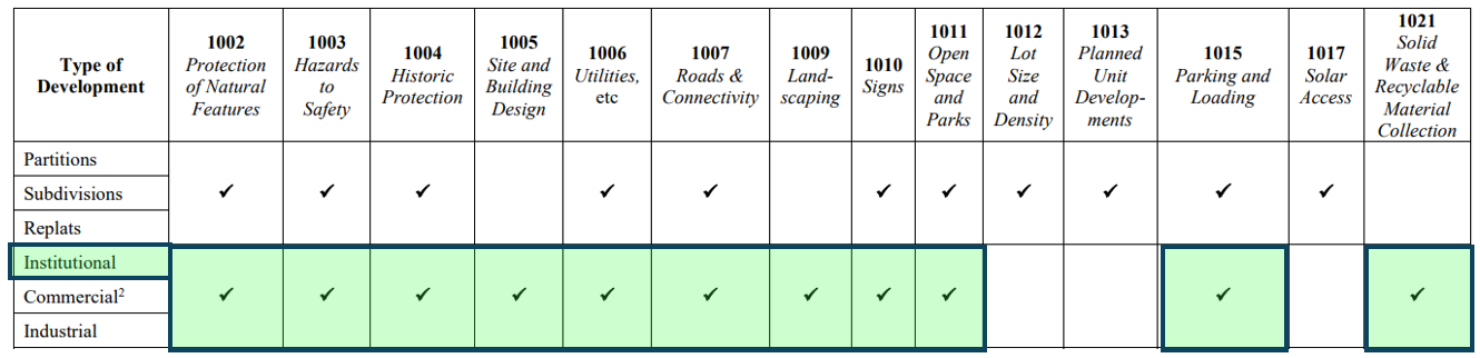
A photovoltaic solar power generation facility meets the definition of a utility facility and a utility facility is considered an institutional use pursuant to the definition in ZDO 202:
INSTITUTIONAL USE: The use of land and/or structures for activities such as child care, adult daycare and pre-school facilities, public and private schools, colleges, universities, art, music, trade and other educational and training facilities, convalescent care facilities, nursing homes, hospitals, places of worship, fraternal lodges, municipal and civic buildings, transit centers and park-and-ride facilities, parks, swimming pools and other recreational facilities open to the public or a membership group, senior and community centers, libraries, museums, cemeteries and mausoleums, utility facilities, and similar public and private uses.
An institutional use is subject to the following:
Table 1001-1 Applicability of Section 1000.
ZDO Section 1002, Protection Of Natural Features
Finding: The subject site does not contain slopes greater than 20 percent or known river or stream features regulated by the ZDO. As noted by the applicant, “There appear to be slopes of approximately 16% on the subject parcel, but not within the development area. The proposed use is not grading, stripping vegetation, or covering the lot by structures and impervious surfaces.” (Exhibit 2a at 12). The property does contain a water feature on the statewide wetland inventory but the development is located more than 500 feet from the waterway. The subject property is outside the mapped deer and elk winter range. The property contains a significant clump of trees on the eastern portion of the site but no development is proposed in that location of the property, leaving the wooded area undisturbed.
These criteria are met.
ZDO Section 1003, Hazards To Safety
Finding: The subject site contains no mapped: mass movement hazards, special flood hazard areas, or soil hazard areas. The property is outside the Urban Growth Boundary and it has unknown wildfire risk since the Oregon Wildfire Risk maps produced by ODF and Oregon State University has been repealed by the passage of 2025 Senate Bill 83. There are no steep slopes on the property. These criteria are not applicable.
ZDO Section 1004, Historic Protection
Finding: The subject property is not a Historic Landmark, and is not located in a Historic District or Historic Corridor. Therefore there are no known historic resources on the subject site. These criteria are not applicable.
ZDO Section 1005, Site and Building Design
1005.02 GENERAL SITE DESIGN STANDARDS
The following site design standards apply:
A. Where feasible, cluster buildings within single and adjacent developments for efficient sharing of walkways, on-site vehicular circulation, connections to adjoining sites, parking, loading, transit-related facilities, plazas, recreation areas, and similar amenities.
B. Where feasible, design the site so that so that the longest building elevations can be oriented within 20 degrees of true south in order to maximize the south-facing dimensions.
C. Minimum setbacks may be reduced by up to 50 percent as needed to allow improved solar access when solar panels or other active or passive solar use is incorporated into the building plan.
ZDO 202 defines buildings as:
“BUILDING: Any structure used or intended for supporting or sheltering any use or occupancy.”
Finding: Although the solar facility includes structures, there are no buildings proposed by the solar facility proposal.
These criteria are not applicable.
D. A continuous, interconnected on-site walkway system meeting the following standards shall be provided.
1. Walkways shall directly connect each building public entrance accessible to the public to the nearest sidewalk or pedestrian pathway, and to all adjacent streets, including streets that dead-end at the development or to which the development is not oriented.
2. Walkways shall connect each building to outdoor activity areas including parking lots, transit stops, children’s play areas, and plazas.
3. Walkways shall be illuminated. Separate lighting shall not be required if existing lighting adequately illuminates the walkway.
4. Walkways shall be constructed with a well-drained, hard-surfaced material or porous pavement and shall be at least five feet in unobstructed width.
5. Standards for walkways through vehicular areas:
a. Walkways crossing driveways, parking areas, and loading areas shall be constructed to be clearly identifiable to motorists through the use of different paving material, raised elevation, warning signs, or other similar methods.
b. Where walkways are adjacent to driveways, they shall be separated by a raised curb, bollards, landscaping, or other physical barrier.
c. Inside the Portland Metropolitan Urban Growth Boundary (UGB), if the distance between the building public entrance and street is 75 feet or greater and located adjacent to a driveway or in a parking lot, the walkway shall be raised, with curbs, a minimum four-foot-wide landscape strip and shade trees planted a maximum of 30 feet on center.
d. The exclusive use of a painted crossing zone to make walkways identifiable to motorists may be used only for portions of walkways which are shorter than 30 feet and located across driveways, parking lots, or loading areas.
e. Walkways bordering parking spaces shall be at least seven feet wide or a minimum of five feet wide when concrete bumpers, bollards, curbing, landscaping, or other similar improvements are provided which prevent parked vehicles or opening doors from obstructing the walkway.
6. The interconnected onsite walkway system shall connect to walkways in adjacent developments, or stub to the adjacent property line if the adjacent land is vacant or is developed without walkways.
a. Walkway stubs shall be located in consideration of topography and eventual redevelopment of the adjacent property.
b. Notwithstanding the remainder of Subsection 1005.02(D)(6), walkway linkages to adjacent development shall not be required within industrial developments, to industrial developments, or to vacant industrially zoned land.
Finding: There are no buildings to connect with a walkway system. As an unmanned utility facility there is only one small parking area near S. Metzler Park Road and a fire turnaround near the top of the development. With no staff working on or visitors to the site there is no need to connect the parking area to the solar arrays through established walkways. There are no adjacent developments, parks or uses that would be used by the solar facility staff that periodically monitors the site.
These criteria are not applicable.
E. Inside the UGB, except for industrial developments, a minimum of 50 percent of the street frontage of the development site shall have buildings located at the minimum front setback line.
F. Inside the UGB, parking lots larger than three acres in size shall be built with major on-site vehicular circulation ways that include raised walkways with curbs, a minimum four-foot-wide landscape strip, and shade trees planted a maximum of 30 feet on center.
G. New retail, office, mixed use, and institutional buildings located on major transit streets shall have at least one public entrance facing a major transit street, or street intersecting a major transit street.
H. New retail, office, mixed use, multifamily, and institutional buildings located at a major transit stop shall be set back a maximum of 20 feet from at least one of the following: the major transit stop, the major transit street or an intersecting street, or a pedestrian plaza at the major transit stop or a street intersection.
I. In the PMU District, there shall be no vehicular parking or circulation within the front setback area.
J. In the OC District, the design and siting of structures shall control public access points into office buildings, utilizing a central lobby design, entrance courtyard, internal pedestrian walkway or mall, or similar designs that protect business/professional uses from the disturbances of direct public access.
K. Where a minimum floor area ratio (FAR) is required by the standards of the applicable zoning district, it shall be calculated as follows:
L. The following standards apply in the HDR, RCHDR, and SHD Districts:…
Finding: The subject site is located outside the UGB, in an area without transit. The site is in the EFU District which has no minimum FAR. Although the solar facility is considered an institutional use, the public does not visit or enter the utility facility for public health and safety reasons.
These criteria are not applicable.
1005.03 BUILDING DESIGN
Finding: No buildings are proposed with this application.
These criteria are not applicable.
1005.04 OUTDOOR LIGHTING
A. Outdoor lighting devices:
1. Shall be architecturally integrated with the character of the associated structures, site design, and landscape.
2. Shall not direct light skyward.
3. Shall direct downward and shield light; or direct light specifically toward walls, landscape elements, or other similar features, so that light is directed within the boundaries of the subject property;
4. Shall be suitable for the use they serve (e.g. bollard lights along walkways, pole mounted lights for parking lots);
5. Shall be compatible with the scale and intensity of uses they are serving. The height of pole-mounted fixtures shall not exceed 25 feet or the height of the tallest structure onsite, whichever is less; and
6. At entrances, shall be glare-free. Entrance lighting may not exceed a height of 12 feet and must be directed downward.
B. The following are exempt from Subsection 1005.04(A):
1. Temporary lights used for holiday decorations;
2. Street lights regulated in Section 1006, Utilities, Street Lights, Water Supply, Sewage Disposal, Surface Water Management, and Erosion Control; and
3. Lighting associated with outdoor recreation uses such as ball fields or tennis courts.
Finding: No outdoor lighting is proposed.
These criteria are not applicable.
1005.05 ADDITIONAL REQUIREMENTS
Development shall comply with a minimum of one of the following techniques per 20,000 square feet of site area. Regardless of site size, a minimum of one and a maximum of five techniques are required. Partial site area numbers shall be rounded.
A. Install a solar energy system in the development.
B. Use passive solar heating or cooling techniques to reduce energy consumption.
Examples of techniques:
1. Modulate building masses to maximize solar access.
2. For developments with more than one structure, locate taller structures to minimize negative impacts on solar access for the development site and adjacent sites.
3. Locate buildings to maximize windbreaks.
4. Locate structures and landscaping to avoid winter shading on the south side and optimize summer shading on the west and southwest sides of buildings.
5. Utilize deciduous trees to provide summer shade and allow winter sun.
6. Utilize deciduous vines on fences, trellises, and arbors to provide summer shade.
7. Locate and form berms to protect buildings and exterior use spaces against winter winds or utilize dense evergreens or conifers to screen winter wind and protect against hostile winter elements.
8. Provide skylights or clerestory windows to provide natural lighting, and/or solar heating of interior spaces.
C. Use highly reflective (high albedo) materials on roof surfaces.
D. Place major outdoor use areas such as plazas, playgrounds, gardens, etc. on the south side of buildings.
E. Construct a minimum of 75 percent of walkway area of porous pavement.
F. Construct a minimum of 75 percent of all parking spaces with porous pavement.
G. Provide additional landscaping area at least 10 percent above the requirement for the site pursuant to Table 1009-1, Minimum Landscaped Area. For example, if the minimum area requirement is 20 percent, then 22 percent shall be provided. Credit shall be given for green roofs or other areas of vegetation that exceed the minimum area requirements.
H. Include additional swales in development landscaping, pursuant to Section 1009, Landscaping. Credit shall be given for additional swale(s) that exceed the requirements of Subsection 1009.04(A)(2) by at least 10 percent of area. For example, if 1009.04(A)(2) requires 200 square feet of swale area, then an additional 20 square feet of swale area would be required.
I. Collect rainwater from roofs and/or other impervious surfaces and use it for irrigation.
J. Apply other techniques for onsite storm water treatment identified by the surface water management regulatory authority.
K. Lay out sites and locate buildings and on-site vehicular circulation to create functional open areas such as plazas, courtyards, outdoor recreation areas, miniparks, and accessways that are open to the general public.
Finding: The application materials show that the development is a solar energy system. The Transportation and Engineering Program is the surface water management agency for the subject site. Transportation and Engineering staff stated “When more than one acre is disturbed, a 1200-C permit is required through the Department of Environment Quality (DEQ). Based on the 12 acre solar facility area, a 1200-C permit will be required.” (Exhibit 4). Thus other techniques for onsite storm water treatment will be met.
As conditioned these criteria can be met.
ZDO Section 1006, Utilities, Street Lights, Water Supply, Sewage Disposal, Surface Water Management, and Erosion Control
1006.01 GENERAL STANDARDS
A. The location, design, installation, and maintenance of all utility lines and facilities shall be carried out with minimum feasible disturbance of soil and site consistent with the rules and regulations of the surface water management regulatory authority.
B. All development that has a need for electricity, natural gas, and communications services shall install them pursuant to the requirements of the utility district or company serving the development. Except where otherwise prohibited by the utility district or company, utility service lines shall be installed underground.
C. Coordinated installation of necessary water, sanitary sewer, and surface water management and conveyance facilities is required.
D. Easements shall be provided along lot lines as deemed necessary by the County, special districts, and utility companies. Easements for special purpose uses shall be of a width deemed appropriate by the responsible agency.
Finding: As conditioned these criteria are met.
1006.02 STREET LIGHTS
Street lights are required for all development inside the Portland Metropolitan Urban Growth Boundary. The following standards apply:
Finding: The subject property is located outside the Portland Metropolitan Urban Growth Boundary. Therefore, street lights not are required.
These criteria are inapplicable.
1006.03 WATER SUPPLY
Finding: Water service is not required for the proposed unmanned utility facility.
These criteria are not applicable.
1006.04 SANITARY SEWER SERVICE
Finding: The subject property is outside of all sanitary sewer districts and is not able to be served by a sanitary sewer service.
These criteria are not applicable.
1006.05 ONSITE WASTEWATER TREATMENT
Finding: The site is located outside of the UGB and wastewater treatment is not required for the proposed unmanned utility facility.
These criteria are not applicable.
1006.06 SURFACE WATER MANAGEMENT AND EROSION CONTROL
The following surface water management and erosion control standards apply:
A. Positive drainage and adequate conveyance of surface water shall be provided from roofs, footings, foundations, and other impervious or near-impervious surfaces to an appropriate discharge point.
B. The requirements of the surface water management regulatory authority apply. If the County is the surface water management regulatory authority, the surface water management requirements of the Clackamas County Roadway Standards apply.
C. Approval of a development shall be granted only if the applicant provides a preliminary statement of feasibility from the surface water management regulatory authority. The statement shall verify that adequate surface water management, treatment and conveyance is available to serve the development or can be made available through improvements completed by the developer or the system owner.
1. The surface water management regulatory authority may require a preliminary surface water management plan and report, natural resource assessment, and buffer analysis prior to signing the preliminary statement of feasibility.
2. The statement shall be dated no more than one year prior to the date a complete land use application is filed and need not reserve surface water treatment and conveyance system capacity for the development.
D. Development shall be planned, designed, constructed, and maintained to:
1. Protect and preserve existing natural drainage channels to the maximum practicable extent;
2. Protect development from flood hazards;
3. Provide a system by which water within the development will be controlled without causing damage or harm to the natural environment, or to property or persons within the drainage basin;
4. Ensure that waters drained from the development are substantially free of pollutants, including sedimentary materials, through such construction and drainage techniques as sedimentation ponds, reseeding, and phasing of grading; and
5. Ensure that waters are drained from the development in such a manner that will not cause erosion to any greater extent than would occur in the absence of development.
E. Where culverts cannot provide sufficient capacity without significant environmental degradation, the County may require the watercourse to be bridged or spanned.
F. If a development, or any part thereof, is traversed by any watercourse, channel, stream, creek, gulch, or other natural drainage channel, adequate easements for surface water management purposes shall be provided to the surface water management regulatory authority.
G. Channel obstructions are not allowed, except as approved for the creation of detention, retention, or hydropower facilities approved under this Ordinance. Fences with swing gates may be utilized.
H. The natural drainage pattern shall not be substantially altered at the periphery of the subject property. Greatly accelerated release of stored water is prohibited. Flow shall not be diverted to lands that have not previously encountered overland flow from the same upland source unless adjacent downstream owners agree.
I. A surface water management and erosion control plan is required for significant residential, commercial, industrial, and institutional development. The plan shall include: 1. The methods to be used to minimize the amount of runoff siltation and pollution created from the development both during and after construction; and 2. Other elements required by the surface water management authority.
Finding: The subject property is located outside surface water management districts, therefore the Clackamas County Transportation and Engineering Program is the surface water management agency. As indicated by the preliminary statements of feasibility signed the November 5, 2025, by the Clackamas County Transportation and Engineering Program, the onsite surface water treatment requirements for the proposed use can be met. (Exhibit 2 at 28). The storm drainage facilities for the proposed development will be reviewed with the Development Permit. Exhibit 4 provides “When more than one acre is disturbed, a 1200-C permit is required through the Department of Environment Quality (DEQ). Based on the 12 acre solar facility area, a 1200-C permit will be required.” Thus the surface water treatment will be met.
As conditioned these criteria are met.
1007 ROADS AND CONNECTIVITY
1007.01 GENERAL PROVISIONS
A. The location, alignment, design, grade, width, and capacity of all roads shall conform to Section 1007, Chapters 5 and 10 of the Comprehensive Plan, and the Clackamas County Roadway Standards. Where conflicts occur between Section 1007, the Comprehensive Plan, and the Clackamas County Roadway Standards, the Comprehensive Plan shall control.
B. Right-of-way dedications and improvements shall be required of all new developments, including partitions, subdivisions, multifamily dwellings, duplexes, triplexes, quadplexes, townhouses, cottage clusters, detached single-family dwellings, and commercial, industrial, and institutional uses, consistent with Section 1007, Chapters 5 and 10 of the Comprehensive Plan, and the Clackamas County Roadway Standards.
Finding: No new roads are proposed with this development. The County argued that the applicant should be required to dedicate ten feet of right of way adjacent to the development to comply with the Comprehensive Plan and Roadway Standards for right-of-way width. However, in order to require such an exaction the County must prove that the cost of the right-of-way is roughly proportional to the impacts of the proposed development. Dolan v. City of Tigard, 512 U.S. 374 (1994). The proposed solar facility will be unmanned and will generate very few vehicle trips once construction is completed. The County made no effort to demonstrate that the required right-of-way dedication is roughly proportional. Therefore, the hearings officer finds that the County failed to carry its burden of proof and the applicant cannot be required to dedicate right-of-way. Proposed condition of approval 12.a should be deleted.
These criteria are met.
C. New developments shall have access points connecting with existing roads.
1. Intersection spacing and access control shall be based on Subsection 3.08.110(E) of the Metro Code (Regional Transportation Functional Plan); Chapters 5 and 10 of the Comprehensive Plan; and the Clackamas County Roadway Standards.
2. For development on any portion of a contiguous site identified on Comprehensive Plan Map 5-6, Potentially Buildable Residential Sites > 5 Acres in UGB, the applicant shall provide a conceptual map of new streets for the entire site. The map shall identify street connections to adjacent areas to promote a logical, direct, and connected system of streets; demonstrate opportunities to extend and connect new streets to existing streets, and provide direct public right-of-way routes. Closed-end street designs shall be limited to circumstances in which barriers prevent full street extensions. Closed-end streets shall not exceed 200 feet in length and shall serve no more than 25 dwelling units. Subsequent development on the site shall conform to the conceptual street map, unless a new map is approved pursuant to Subsection 1007.01(C)(2).
3. Access control shall be implemented pursuant to Chapter 5 of the Comprehensive Plan and the Clackamas County Roadway Standards considering best spacing for pedestrian access, traffic safety, and similar factors.
4. Approaches to public and county roads shall be designed to accommodate safe and efficient flow of traffic and turn control where necessary to minimize hazards for other vehicles, pedestrians, and bicyclists.
5. Joint access and circulation drives utilizing reciprocal easements shall be utilized as deemed necessary by the Department of Transportation and Development. In the NC District, joint street access for adjacent commercial developments shall be required.
6. In the SCMU District, driveways shall be spaced no closer to one another than 35 feet, measured from the outer edge of the curb cut, unless compliance with this standard would preclude adequate access to the subject property as a result of existing off-site development or compliance with the Clackamas County Roadway Standards.
7. In the VA District, no direct motor vehicle access is permitted on Sunnyside Road.
8. Inside the Portland Metropolitan Urban Growth Boundary:
Finding: The subject property is not in the NC, VA, or SCMU District and is not located in a station community or inside the Portland Metro Urban Growth Boundary. Joint access is not proposed. The driveway serving the site will need to be constructed to meet the Clackamas County Roadway Standards as discussed in more detail in Exhibit 4.
As conditioned these criteria can be met.
D. Street alignments, intersections, and centerline deflection angles shall be designed according to the standards set forth in Chapters 5 and 10 of the Comprehensive Plan and the Clackamas County Roadway Standards.
E. All roads shall be designed and constructed to adequately and safely accommodate vehicles, pedestrians, and bicycles according to Chapters 5 and 10 of the Comprehensive Plan and the Clackamas County Roadway Standards. Development-related roadway adequacy and safety impacts to roadways shall be evaluated pursuant to the Clackamas County Roadway Standards and also to Oregon Department of Transportation standards for state highways.
F. Roadways shall be designed to accommodate transit services where transit service is existing or planned and to provide for the separation of motor vehicles, bicycle, and pedestrian traffic, and other modes as appropriate
Finding: No new roads are proposed with this development. The public road adjacent to the site does not serve as a transit service route. The subject property is served by a public county road and the driveway will be reviewed for adequacy, safety, and compliance with the Comprehensive Plan and Roadway Standards through a Development Permit from Clackamas County Department of Transportation and Development.
As conditioned these criteria are met.
1007.02 PUBLIC AND PRIVATE ROADWAYS
A. All roadways shall be developed according to the classifications, guidelines, tables, figures, and maps in Chapters 5 and 10 of the Comprehensive Plan and the provisions of the Clackamas County Roadway Standards.
B. The layout of new public and county roads…
C. New county and public roads terminating in cul-de-sacs or other dead-end turnarounds are prohibited….
Finding: The property is not a scenic road included in Comprehensive Plan Map 5-1 and is not on Map IV-8. The subject property is not located in a center, corridor or station community; and is outside of the area included on Map 5-5. No new public or county roads are proposed. The subject property is not located in: Government Camp; the Sunnyside Corridor; the Sunnyside Village; the Regional Center, or Mount Hood Resource Protection Area. Therefore there are no specific design standards for the road that is adjacent to the site beyond the provisions in the Roadway Standards for access.
No new roads are being developed.
These criteria are not applicable.
D. Developments shall comply with the intersection sight distance and roadside clear zone standards of the Clackamas County Roadway Standards. In addition:
1. No planting, signing, or fencing shall be permitted which restricts motorists’ vision; and
2. Curbside parking may be restricted along streets with visibility problems for motorists, pedestrians, and/or bicyclists as deemed appropriate by the Department of Transportation and Development.
E. New developments, subdivisions, and partitions may be required to dedicate land for right-of-way purposes and/or make road frontage improvements to existing rights-of-way, consistent with Section 1007, Chapters 5 and 10 of the Comprehensive Plan, and the Clackamas County Roadway Standards.
Finding: The intersection sight distance and roadside clear zone for the existing access drive along the western property boundary cannot be impeded by the fence proposed around the development. As originally proposed, the site plan and fence description in the application showed that required sight distance triangles were likely blocked for the existing access drive to the west of the development. However, the applicant’s revised site plan shifted the fence and gate 30 feet back from the roadway intersection in order to maintain adequate sight distance.
As discussed above, the County failed to demonstrate that the cost of right-of-way dedication is roughly proportional to the impacts of the proposed facility.
This criterion is met as conditioned.
F. Road frontage improvements within the UGB and in Government Camp, Rhododendron, and Wemme/Welches shall include:
Finding: The site is outside of the UGB and is not in Government Camp, Rhododendron, or Wemme/Welches.
This criterion is not applicable.
1007.03 PRIVATE ROADS AND ACCESS DRIVES
Finding: No private roads are proposed. The proposed site driveway is not an “access drive” as defined by ZDO 2022. Additional access improvements will be evaluated through the Transportation and Engineering Development Permit.
These criteria are not applicable.
1007.04 PEDESTRIAN AND BICYCLE FACILITIES
A. General Standards: Pedestrian and bicycle facilities shall be developed according to the classifications and guidelines listed in Section 1007, Comprehensive Plan Figures 5-1 through 5-3, Typical Roadway Cross Sections, Chapters 5 and 10 of the Comprehensive Plan, and the Clackamas County Roadway Standards.
B. Pedestrian and Bicycle Facility Design: Pedestrian and bicycle facilities shall be designed to:
1. Minimize conflicts among automobiles, trucks, pedestrians, and bicyclists;
2. Provide safe, convenient, and an appropriate level of access to various parts of the development and to locations such as schools, employment centers, shopping areas, adjacent developments, recreation areas and open space, and transit corridors;
3. Allow for unobstructed movements and access for transportation of disadvantaged persons; and
4. Be consistent with Chapters 5 and 10 of the Comprehensive Plan; Comprehensive Plan Maps 5-2a, Planned Bikeway Network, Urban, 5-2b, Planned Bikeway Network, Rural, and 5-3, Essential Pedestrian Network; North Clackamas Parks and Recreation District’s (NCPRD) Park and Recreation Master Plan; and Metro’s Regional Trails and Greenways Map.
C. Requirements for Pedestrian and Bicycle Facility Construction: Within the Portland Metropolitan Urban Growth Boundary (UGB).
D. Requirement for Sidewalk Construction: Within the UGB,….
E. Sidewalks or Pedestrian Pathways in Unincorporated Communities: In an unincorporated community,….
F. Sidewalk Location: Sidewalks required by Subsection 1007.04(C) or (D)….
G. Pedestrian Pathways: Within the UGB….
Finding: Pedestrian and bicycle facilities and sidewalks are not required as the site is outside of the UGB and unincorporated communities.
These criteria are met as conditioned.
1007.07 TRANSPORTATION FACILITIES CONCURRENCY
A Subsection 1007.07 shall apply to the following development applications: design review, subdivisions, partitions, and conditional uses.
B. Approval of a development shall be granted only if the capacity of transportation facilities is adequate or will be made adequate in a timely manner. The following shall be exempt from this requirement:
…
3 Unmanned utility facilities, such as wireless telecommunication facilities, where no employees are present except to perform periodic servicing and maintenance;
Finding: The proposed use is is an unmanned utility facility and therefore exempt from the concurrency requirements pursuant to ZDO 1007.07(B)(3).
These criteria are not applicable.
1009 LANDSCAPING
1009.01 GENERAL PROVISIONS
A. Landscaping materials shall be selected and sited to produce a hardy and low-maintenance landscaped area with an emphasis on fast-growing plants. Selection shall include consideration of soil type and depth, spacing, exposure to sun and wind, slope and contours of the subject property, building walls and overhangs, and compatibility with existing vegetation to be preserved. Notwithstanding the requirement for hardiness, annuals are permitted as provided in Subsection 1009.01(B).
B. A variety of plants, intermixed throughout landscaped areas, shall be provided, as follows:
1. Evergreen and deciduous;
2. Trees, shrubs, and groundcover;
3. Plants of varying textures;
4. Plants of varying widths and heights at maturity; and
5. Plants with seasonal color interest (e.g., foliage, flowering perennials, annuals).
C. The planting of invasive non-native or noxious vegetation shall be prohibited, and existing invasive non-native or noxious vegetation shall be removed.
D. Landscaped areas shall not be used for other purposes, such as storage or display of automobiles, equipment, merchandise, or materials.
E. Landscaping of the unimproved area between a lot line and the improved portion of an adjacent road right-of-way shall be required when there are no immediate plans to develop or otherwise disturb the unimproved area, and one or more of the following apply:
1. The subject property is located inside the Portland Metropolitan Urban Growth Boundary;
2. Landscaping is necessary to present an appearance consistent with the proposed development as viewed from the road;
3. Landscaping is necessary to reduce dust, noise, erosion, or fire hazard; or
4. The road is designated as a scenic road on Comprehensive Plan Map 5-1, Scenic Roads
F. Landscaping shall be used to highlight public entrances to buildings. If—due to the depth of a front setback, a required walkway, or both—there is insufficient area to permit a typical, in-ground landscaping bed between a public entrance and a front lot line, this requirement may be met with trellises, hanging baskets, or planters, any of which shall include plants.
G. Where feasible, landscaping shall be required adjacent to walkways and other areas intended for pedestrian use.
H. Existing significant plants, terrain, and other natural features shall be incorporated into the landscaping design and development if such features are required to be retained by other provisions of this Ordinance or if otherwise feasible.
Finding: The subject site is outside the Portland Metropolitan Urban Growth Boundary. There are no buildings or walkways proposed or required by the development. S. Metzler Park Road is not designated a scenic road on Clackamas County Comprehensive Plan Map 5-1. Therefore, landscaping is not required.
These criteria are inapplicable.
1009.02 MINIMUM AREA STANDARDS
A. Table 1009-1, Minimum Landscaped Area, establishes the minimum percentage of the area of the subject property that shall be landscaped.
Finding: The proposed use is a conditional use in the EFU District so Table 1009-1 has no minimum requirements for landscaped area.
These criteria are not applicable.
1009.03 SURFACE PARKING AND LOADING AREA LANDSCAPING
Surface parking and loading areas shall be landscaped as follows:
A. Surface parking areas that include more than 15 parking spaces shall comply with the following landscaping requirements: …..
B. Perimeter landscaping requirements for surface parking and loading areas adjacent to abutting lots or rights-of-way are as follows:
1. A landscaping strip with a minimum width of five feet shall be provided adjacent to the perimeter of the surface parking or loading area, except: a. In the OA, VA, VCS, and VO Districts, the minimum width shall be 10 feet; b. In the BP and LI Districts, the minimum width shall be 15 feet abutting a front lot line; and c. In the GI District, the minimum width shall be 10 feet abutting a front lot line.
2. The required landscaping strips shall comply with the following standards: a. Sufficient low shrubs shall be planted to form a continuous screen three feet high and 95 percent opaque, year-round; or a three-foot-high masonry wall or berm may be substituted for the shrubs. When applied along front lot lines, the screen or wall is to be placed along the interior side of the landscaping strip and shall be 30 inches high instead of three feet high. b. In addition, one tree is required for every 30 linear feet of landscaping strip, or as otherwise required to provide a tree canopy over the landscaping strip. c. Ground cover plants must fully cover the remainder of the landscaped area.
3. A perimeter landscape strip is not required for a surface parking or loading area adjacent to an abutting lot if one or more interior driveways connect the two lots and if the abutting lot also is developed with a surface parking or loading area adjacent to the shared lot line.
Finding: The proposed use includes 1-2 parking spaces on the south side of the site adjacent to the right of way of S. Metzler Park Road. The applicant is proposing to screen the parking from the right of way with a seven-foot tall wood slatted/picket fence. The wood slated fence will provide the visual barrier between the proposed parking and the public road.
These criteria are met.
1009.04 SCREENING AND BUFFERING
A. Screening shall be used to eliminate or reduce the visual impacts of the following: 1. Service areas and facilities, such as loading areas and receptacles for solid waste or recyclable materials; 2. Storage areas; 3. Ground-mounted rainwater collection facilities with a storage capacity of more than 100 gallons; 4. Parking lots within or adjacent to an Urban Low Density Residential, VR-5/7, VR-4/5, RA-1, RA-2, RR, RRFF-5, FF-10, FU-10, or HR District; and 5. Any other area or use, as required by this Ordinance.
B. Screening shall be accomplished by the use of sight-obscuring evergreen plantings, vegetated earth berms, masonry walls, sight-obscuring fences, proper siting of disruptive elements, building placement, or other design techniques.
C. Screening shall be required to substantially block any view of material or equipment from any point located on a street or accessway adjacent to the subject property. Screening from walkways is required only for receptacles for solid waste or recyclable materials. A sight-obscuring fence at least six feet in height and up to a maximum of 10 feet in height shall be required around the material or equipment.
D. Buffering shall be used to mitigate adverse visual impacts, dust, noise, or pollution, and to provide for compatibility between dissimilar adjoining uses. Special consideration shall be given to buffering between residential uses and commercial or industrial uses, and in visually sensitive areas.
E. Buffering shall be accomplished by one of the following: 1. A landscaping strip with a minimum width of 15 feet and planted with: a. A minimum of one row of deciduous and evergreen trees staggered and spaced a maximum of 30 feet apart; b. A perennial, evergreen planting with sufficient foliage to obscure vision and which will grow to form a continuous hedge a minimum of six feet in height within two years of planting; and c. Low-growing evergreen shrubs and evergreen ground cover covering the balance of the area;
Finding: The proposed development includes a solar facility. There are existing residential uses on the properties to the west and on the subject site east of the developed area. The applicant states:
The purpose of Screening is to eliminate or reduce the visual impacts of services areas, storage, and rainwater collection facilities. The proposed use will not contain any of these facilities. While it is not required, the Applicant proposes to build a sight obscuring wood slatted fence up to 8ft tall, around the entirety of the facility to screen the use from the neighboring properties and the street. This will reduce any visual impact the facility may have on the surrounding area.
The purpose of Buffering is “…to mitigate adverse visual impacts, dust, noise, or pollution, and to provide for compatibility between dissimilar adjoining uses.” As stated previously in the findings for OAR 660-033-0130(5) and OAR 340-035-0035(B)(i), the proposed use does not create loud noises, dust, or pollution. There is no need to buffer the facility from the other allowed uses in the adjoining EFU and TBR zoned parcels that create more noise, dust, and pollution than the proposed use. Therefore, buffering is not relevant.
(Exhibit 2a at 13).
The hearings officer agrees with the applicant’s findings. During the open record period the applicant specified that the proposed perimeter fence will be a seven-foot tall wood slatted/picket fence. (Exhibit 18 at 8).
These criteria are met.
1009.07 FENCES AND WALLS
A. Fences and walls shall be of a material, color, and design complementary to the development.
Finding: As noted above the applicant proposes a seven foot wood slatted fence. No color was identified.
These criteria are met.
1009.08 RECREATIONAL AREAS AND FACILITIES
Finding: The applicant is not proposing the development of duplexes, triplexes, quadplexes, or multifamily dwellings in the MR-1, MR-2, or HDR Districts.
These criteria are not applicable.
1009.09 EROSION CONTROL
Finding: As noted above, the Clackamas County Transportation and Engineering Program is the Surface Water Management authority for the subject property.
These criteria are met as conditioned.
1009.10 PLANTING AND MAINTENANCE
Finding: Because existing vegetation and a wooden fence are proposed to meet the landscaping needs, irrigation, and maintenance of new landscaping material is not needed.
These criteria are met.
1010 SIGNS
Finding: The applicant did not include any sign designs or specifications. In the narrative they state that any signage will comply with this section of the code. A condition of approval is warranted to ensure that future signage meets these requirements.
These criteria can be met.
1011 OPEN SPACE AND PARKS
Finding: The subject property is not included on the Comprehensive Plan Map IV-6, North Urban Area Land Use Plan Map, or on the Mt. Hood Community Plan Map. As noted above for ZDO 1002, the location of the proposed solar facility is more than 500 feet from the wetlands identified on the Statewide Wetland Inventory and outside of the part of the property that has slopes of about 16%.
These criteria are not applicable.
1015 PARKING AND LOADING
1015.01 GENERAL STANDARDS
A. Inside the Portland Metropolitan Urban Growth Boundary (UGB),….
B. Outside the UGB, areas used for parking, loading, and maneuvering of vehicles shall be surfaced with screened gravel or better, and shall provide for suitable drainage.
C. Parking and loading requirements for uses and structures not specifically listed in Tables 1015-1, Automobile Parking Space Requirements; 1015-2, Minimum Automobile Parking Space Requirements for Dwellings; 1015-3, Minimum Required Bicycle Parking Spaces; and 1015-4, Minimum Required Off-Street Loading Berths shall be subject to the requirements for the most similar use.
D. Motor vehicle parking, bicycle parking, and loading areas shall be separated from one another.
E. Required parking spaces and loading berths shall not be: a. Rented, leased, or assigned to any other person or organization, except as provided for under Subsection 1015.02(D)(3)(a) for shared parking or Subsection 1015.04(C) for shared loading berths. b. Used for storing or accumulating goods or storing a commercial or recreational vehicle, camper, or boat, rendering the space(s) useless for parking or loading operations. c. Occupied by the conducting of any business activity, except for permitted temporary uses (e.g., farmers’ markets).
Finding: The subject property is outside the Portland Metropolitan Urban Growth Boundary (UGB) and the parking, loading, and maneuvering areas will be surfaced with screened gravel or better, and shall provide for suitable drainage as verified through a Development Permit with the Clackamas County Transportation and Engineering Program. The site plan submitted in the application shows that the parking will be provided in spaces shown on the site plan near the southern extent of the project and an driveway will extend from there through the site to enable adequate vehicle circulation as shown by the letter of approval from the local Fire Department dated December 3, 2025. (Exhibit 2 at 91).
These criteria can be met as conditioned.
1015.02 MOTOR VEHICLE PARKING AREA STANDARDS
A. Off-street parking areas shall be designed to meet the following requirements:….
Finding: The submitted site plan shows the parking space dimensions, surface material and number requirements are met and compliance will be verified through a Development Permit with the Clackamas County Transportation and Engineering Program. The applicant showed that with the parking spaces located next to S. Metzler Park Road where there was adequate maneuvering areas for vehicles.
As conditioned these criteria are met.
B. Parking Minimums: The minimum number of parking spaces listed in Tables 1015-1, Automobile Parking Space Requirements, and 1015-2, Minimum Automobile Parking Space Requirements for Dwellings, applies unless modified in Subsection 1015.02(D).
Finding: The land use types in Table 1015-2 do not identify the unmanned utility facility as a use. Therefore, the closest use is Government Miscellaneous use that requires 2.7 spaces for every 1,000 square feet of leasable area. However, there is no area that is leasable because there are no buildings and the site will be only used for the solar facility. The proposed parking area is 20x20 feet and could contain two parking spaces that met the minimum 8.5 x 16 foot dimensional standards, although the site plan only indicates that one parking space is provided.
These criteria are met.
1015.03 BICYCLE PARKING STANDARDS
A. Bicycle parking areas shall meet the following on-site locational requirements:
B. Bicycle parking shall be designed to meet the following requirements:
Finding: Bicycle parking spaces are not required for utility facilities.
These criteria are not applicable.
1015.04 OFF-STREET LOADING STANDARDS
Finding: Table 1015-4, Minimum Required Off-Street Loading Berths, does not identify a minimum number required for an unmanned utility facility. Table 1015-4 does not identify a minimum number of loading docks required for institutional uses that are utility facilities.
These criteria are not applicable.
1021 SOLID WASTE AND RECYCLABLE MATERIAL COLLECTION
Finding: As noted in the application an employee may visit the site for inspections and maintenance, but no offices or daily visits are proposed. The solar facility will have no trash service based on the application materials. Therefore, there is little to no solid waste and recycling anticipated from the solar facility.
These criteria are not applicable.
1203.05 APPROVAL PERIOD AND TIME EXTENSION
A. Approval of a conditional use is valid for four years from the date of the final decision. If the County’s final decision is appealed, the approval period shall commence on the date of the final appellate decision. During this four-year period, the approval shall be implemented, or the approval will become void.
1. Implemented means all major development permits shall be obtained and maintained for the approved conditional use, or if no major development permits are required to complete the development contemplated by the approved conditional use, implemented means all other necessary County development permits (e.g., grading permit, building permit for an accessory structure) shall be obtained and maintained. A major development permit is:
a. A building permit for a new primary structure that was part of the conditional use approval; or
b. A permit issued by the County for parking lot or road improvements required by the conditional use approval.
B. If the approval of a conditional use is not implemented within the initial approval period established by Subsection 1203.05(A), a two-year time extension may be approved pursuant to Section 1310, Time Extension.
Finding: This is informational only.
1203.06 DISCONTINUATION - If a conditional use is implemented pursuant to Subsection 1203.05 and later discontinued for a period of more than five consecutive years, the conditional use shall become void.
Finding: This is informational only.
D. CONCLUSION
Based on the findings and discussion provided or incorporated herein, the hearings officer concludes that Case No. Z0496-25 (Astra Solar) should be approved, because the application does or can comply with applicable standards of the Clackamas County ZDO, provided it is subject to conditions that ensure timely compliance in fact with the ZDO and relevant Comprehensive Plan Policies.
E. DECISION
Based on the findings, discussion and conclusions provided or incorporated herein and the public record in this case, the hearings officer hereby approves Z0496-25 (Astra Solar) subject to the following conditions:
Conditions of Approval:
- Approval of this land use permit is based on the submitted written narrative and plan(s) filed with the County on December 9, 2025, with additional application materials submitted on February 3, 2026, February 4, 2026, March 26, 2026, and April 13, 2026. No work shall occur under this permit other than which is specified within these documents, unless otherwise required or specified in the conditions below. It shall be the responsibility of the property owner(s) to comply with these documents and the limitation of any approval resulting from the decision described herein.
- Access to the project area is prohibited from the access drive described in recorded document # 1976-12104. [ZDO 401.07]
- The applicant shall comply with the recommendations in the soil erosion control and compaction relief plan. As recommended in the plan, earth disturbing activity including grading, installation of utilities and solar panels, and trenching shall be conducted when the soil is dry. [ZDO 401.05(A)(1) and OAR 660-033-0130(38)(h)(B)]
- The applicant shall comply with the recommendations in the weed mitigation plan. As recommended in the plan vehicles and equipment used for the construction of the site should be washed prior to entering the site to reduce the introduction of weeds. Regular inspection of equipment, and site, shall include checking for weeds and weed removal. [ZDO 401.05(A)(1) and OAR 660-033-0130(38)(h)(D)]
- The location, design, installation, and maintenance of all utility lines and facilities shall be consistent with the rules and regulations of the regulatory authority. Utility service lines shall be installed underground unless a letter from the utility district verifies that underground lines are prohibited by their regulations. [ZDO 1006.01]
- Parking spaces and drive aisles shall meet the dimensional requirements of ZDO Section 1015 and Roadway Standards Drawings P100/P200. [ZDO 1015]
- The developer or property owner is responsible for retiring the facility. At the end of the life of facility all non-utility owned equipment, conduits, structures, and foundations will be removed to a depth of at least three feet below grade. [OAR 660-033-0130(38)(m)]
- Any future signage shall meet the requirements of ZDO 1010.
- Prior to Planning and Zoning approval of a building permit for the use authorized by this land use permit, the landowner for the facility shall sign and record in the deed records for Clackamas County a document binding the landowner, and the landowner's successors in interest, prohibiting them from pursuing a claim for relief or cause of action alleging injury from farming or forest practices as defined in ORS 30.930(2) and (4). A copy of the recorded document shall be submitted to Planning and Zoning. [OAR 660-033-0130(38)(l)]]
- The driveway onto S. Metzler Park Road is required to be constructed to Clackamas County Roadway Standards, including paving of the first 20 feet per Standard Drawing D500. [ZDO 1203.03(C) and ZDO 1007.01(C)(4)]
- The proposed driveway onto S. Metzler Park Road shall meet the minimum access spacing requirements of Clackamas County Roadway Standards Section 220.3 and Table 2-2, measured centerline to centerline from adjacent driveways or roadways. Compliance with access spacing standards shall be verified at the time of Development Permit review.
- The applicant shall provide and maintain the minimum intersection sight distance at the proposed driveway intersection with S. Metzler Park Road. Intersection sight distance shall be free of plantings at maturity, retaining walls, embankments, trees, fences, or any other objects that obstruct vehicular sight distance. Minimum required intersection sight distance is 610 feet in both directions along S Metzler Park Road.
- The proposed gate at the site entrance shall be setback a minimum of 30 feet from the edge of pavement of S. Metzler Park Road, consistent with Roadway Standards Section 230.7.
- Prior to issuance of a building permit the applicant/property owner shall complete the following:
- a. Obtain approval of a 1200-C permit through the Department of Environment Quality (DEQ) is required. A copy of the approved document shall be submitted to Planning and Zoning. [ZDO 1005.05(J) and ZDO 1006.06 (B)]
- b. Obtain approval for the street and site improvement construction plans, in conformance with Clackamas County Roadway Standards Section 140, in the form of a Development Permit (see advisory notes for additional information).
- 12. The Applicant shall provide a noise study to County staff no later than 120 days after the Solar Project becomes fully operational. If the noise study identifies noise levels generated by the facility of more than 10 dBA (in the L10 or L50 hour) in excess of 26 dBA or the actual ambient noise levels at the Swaims’ property line, whichever higher, the Applicant shall propose a modification of the site plan to include noise attenuating measures to ensure that the facility will meet the limits applicable to 340-035-0035(1)(b)(B)(iii), which modification shall be reviewed through a Type II planning process.
DATED this 29th day of April 2026.
Joe Turner, Esq., AICP
Clackamas County Land Use Hearings Officer
Appeal Rights
ZDO 1307.14(D)(6) provides that, with the exception of an application for an Interpretation, the Land Use Hearings Officer’s decision constitutes the County’s final decision for purposes of any appeal to the Land Use Board of Appeals (LUBA). State law and associated administrative rules promulgated by LUBA prescribe the period within which any appeal must be filed and the manner in which such an appeal must be commenced. Presently, ORS 197.830(9) requires that any appeal to LUBA “shall be filed not later than 21 days after the date the decision sought to be reviewed becomes final.” This decision will be “final” for purposes of a LUBA appeal as of the date of mailing (which date appears on the last page herein).
1 The applicant identifies that the property is about 59 acres in size while the tax office indicates that it is about 60 acres.
2 ZDO 202 provides “ACCESS DRIVE: A private way, with a travel surface generally no more than 12 feet in width, created by deed or easement to provide vehicular ingress to, or egress from not more than two lots or parcels.