Translate


Identifying opportunities to improve rules for clarity, usability, and consistency with state law.
Clackamas County is reviewing its zoning and development rules that apply within the Portland Metropolitan area urban growth boundary (UGB) to identify opportunities for improvement. These rules establish land use and development standards for the county, guiding growth, housing, business, and environmental protection.
Explore the Story Map
Visit our interactive Story Map to learn more about zoning in urban unincorporated areas of Clackamas County. The Story Map includes maps, photos, and project background.
Why this project matters
As a primary tool for implementing a comprehensive plan, zoning puts long-term community goals into action by guiding land use decisions in alignment with the plan’s vision. The goal of this assessment is to ensure the Zoning & Development Ordinance (ZDO) contains rules that are clear, user-friendly, and aligned with recent changes to state law. Following the assessment, a report (called the ZDO Diagnostic Report) will provide recommendations to enhance clarity, organization, and consistency in the ZDO. Some recommendations may be implemented immediately, others may be considered for future updates while others may not pursued at all depending on resource availability.
Modernizing our urban zoning and development rules will:
- Improve usability and clarity of zoning regulations
- Address barriers to housing and economic development
- Ensure compliance with state and federal requirements
- Incorporate community input to reflect local priorities
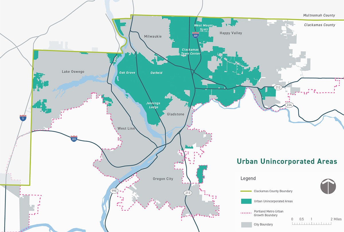
The study area
We will focus on urban, unincorporated areas of Clackamas County, meaning areas with urban services and zoning that are within the Portland Metropolitan Urban Growth Boundary, but not within an incorporated city. Examples of urban, unincorporated areas include Oak Grove, Jennings Lodge, Mt. Scott, Sunnyside, and the McLoughlin corridor.
Project update -- March 17, 2026
The assessment of the ZDO is nearly complete and initial recommendations have been developed. The final report – called the ZDO Diagnostic Report – is expected by the end of April and will include an executive summary, final narrative, and an action plan to assist the county in implementing the recommendations through what will likely be several separate code amendment packages.
The final report will be based on findings and conclusions from a series of topic-specific memorandums in the ZDO:
- Technical Memo 1: Changes needed to comply with the Transportation Planning Rule – the state’s rules that govern the planning for vehicle, bicycle and pedestrian travel and access in the county.
- Technical Memo 2: Changes needed to address existing barriers in ZDO for housing development and recent legislation related to supporting housing development and to ensure development standards are clear and objective.
- Technical Memo 3: Changes needed to support industry clusters, review of Comprehensive Plan Chapter 8, existing barriers in ZDO for employment land development, and transportation standards related to development review
- Technical Memo 4: Identification of specific places in the ZDO and other supporting documents (like the Comprehensive Plan) that need amendments to address issues identified in Tech Memos 1, 2, and 3. Tech Memo 4 will include review and recommendations related to employment/commercial uses and urban housing development.
- Technical Memo 5: Identification of areas in the ZDO that could be amended for greater efficiency, including, but not limited to, combining and consolidating multiple zoning districts into one, removing duplicative and vague standards, and simplifying/clarifying the categories/types of allowed uses
- Technical Memo 6: Summary of outreach efforts conducted for the project.
- Technical Memo 7: Review and comparison of software or platform options to help make the ZDO easier to use online and compliant with accessibility standards.
Once the document is approved, copies can be provided by email upon request. Please contact Martha Fritzie at 503-742-4529 or mfritzie@clackamas.us.
Contact
Martha Fritzie
Project Manager
mfritzie@clackamas.us
503-742-4529