 Translate


Meeting materials
Attend the meeting
- Join via Zoom
- Webinar ID: 868 0260 1890
Free language assistance services are available for this meeting. Contact Darcy Renhard at drenhard@clackamas.us or 503-742-4545 (48-hour notice needed).
Agenda
- Call to order
- Roll call
- Public comment
This is an opportunity for attendees to comment on an issue of concern to the Planning Commission, unless that item is on the agenda for public hearing. Public hearing items, if any, will include an opportunity for public testimony, which will be announced later in the agenda. - Study Session: ZDO-289, ZDO Diagnostic Report‡
Marthe Fritzie, Principal Planner, MFritzie@clackamas.us
Jennifer Hughes, Planning Director, JenniferH@clackamas.us
Karen Buehrig, LR Planning Manager, KarenB@clackamas.us - Minutes‡
Jennifer Hughes - Schedule review
Jennifer Hughes - Other business
Jennifer Hughes - Adjourn
‡ Attachments
| 2026 Planning Commission Meeting Dates | Agenda Items / Notes |
|---|---|
| January 12, 2026 | CANCELLED |
| January 26, 2026 | (PH) Z0315-25-CP/Z0316-25-ZAP |
| February 9, 2026 | CANCELLED |
| February 23, 2026 | Continued hearing: Z0315-25-CP/Z0316-25-ZAP; (SS) ZDO-293: FY 2026 Minor Amendments |
| March 9, 2026 | CANCELLED |
| March 23, 2026 | (SS) ZDO-289: ZDO Diagnostic Report |
| April 13, 2026 | |
| April 27, 2026 | |
| May 11, 2026 | (PH) ZDO-293 FY 2026 Minor Amendments |
| May 25, 2026 (Memorial Day) | |
| June 8, 2026 | |
| June 22, 2026 | |
| July 13, 2026 | |
| July 27, 2026 | Tentative SS: ZDO-290 Clear & Objective Standards |
| August 10, 2026 | Tentative SS: ZDO-290 Clear & Objective Standards |
| August 24, 2026 | |
| September 14, 2026 | |
| September 28, 2026 | |
| October 12, 2026 | |
| October 26, 2026 | |
| November 9, 2026 | |
| November 23, 2026 | |
| December 14, 2026 | |
| December 28, 2026 |
NOTE: (PH)=public hearing, (SS)=study session, (PM)=public meeting
Memorandum
To: Clackamas County Planning Commission
From: Martha Fritzie, Principal Planner
Karen Buehrig, Long Range Planning Manager
Date: March 23, 2026
RE: Study Session: The Zoning & Development Ordinance (ZDO) Diagnostic Report, Planning File #ZDO-289
The purpose of the March 23rd Study Session is to provide the Planning Commission with an update on progress being made on File ZDO-289, the ZDO Diagnostic Report. Planning Commissioners may recall discussions we had last summer about this project – the purpose of which is to conduct a comprehensive assessment of the county’s Zoning & Development Ordinance (ZDO) to (1) identify needed updates to comply with State land use laws, (2) identify areas where the ZDO can be streamlined to reduce inefficiencies and development barriers and to be more understandable and easier to implement, and (3) identify obstacles to employment and housing land development, and opportunities for simplifying and streamlining the ZDO for commercial, industrial and residential development in the urban area.
The results of this review and assessment is a Diagnostic Report, which will contain a compilation of recommended improvements to the ZDO and an action plan that will allow county staff to move forward quickly into the code drafting and adoption process
Where are we with the project?
The consultants have completed a first draft of the ZDO Diagnostic Report, which Planning staff is in the process of reviewing. This report is based on findings and conclusions from a series of “technical memorandums” that focus on specific issue areas in the ZDO, including the following:
- Technical Memo 1: Land use changes needed for compliance with the Transportation Planning Rule
- Technical Memo 2: Clear and objective standards, recent legislation related to supporting housing development, and existing barriers in ZDO for housing development
- Technical Memo 3: Changes needed to support industry clusters, review of Comprehensive Plan Chapter 8, existing barriers in ZDO for employment land development, and transportation standards related to development review
- Technical Memo 4: Identification of places in the ZDO and other supporting documents that need to be addressed per issues outlined in Tech Memos 1, 2, and 3. Tech Memo 4 will include review and recommendations related to employment/commercial uses and urban housing development
- Technical Memo 5: Identification of areas in the ZDO that could be amended for greater efficiency, including, but not limited to, combining and consolidating multiple zoning districts into one, removing duplicative and vague standards, and simplifying/clarifying the categories/types of allowed uses
- Technical Memo 6: Summary of outreach efforts conducted for the project.
- Technical Memo 7: Review and comparison of software or platform options to help make the ZDO more easily accessible online.
The consultants have also completed a first draft of the “action plan” to assist the county in implementing the recommendations through what will likely be several code amendment packages.
What types of outreach occurred with this project?
Because this project was largely technical and for input to be meaningful, participants needed to be somewhat familiar with the county’s ZDO, outreach was largely focused on internal stakeholder groups, including Planning and Engineering staff who review development proposals; Economic Development staff; and Transportation Planning staff. External stakeholders, including developers, architects, land use consultants, interested members of the public, and staff from other jurisdictions, were initially interviewed individually, then invited to participate in a focus group in early 2026. Additional outreach efforts included:
- A dedicated project webpage with background information and an ArcGIS StoryMap which introduced the structure of the ZDO and four key code concepts under evaluation;
- Online surveys, including a general public survey, a targeted stakeholder survey, and a digital engagement board companion survey;
- An in-person open house in October 2025; and
- Staff presentations to the Jennings Lodge and Oak Grove Community Planning Organizations (CPOs) and to the county’s LEDIC (Leaders for Equity, Diversity and Inclusion Council) advisory group in February 2026.
- Feedback from these various conversations was incorporated into the ZDO Diagnostic Report and recommendations.
What types of recommendations are in the Diagnostic Report?
The full ZDO Diagnostic Report includes detailed discussion about number of issues and recommendations for the county to consider. These are summarized in the draft Executive Summary (attached) and generally fall into four categories:
- Usability and Clarity: The current ZDO is difficult to navigate and interpret; decades of incremental updates have layered rules on top of rules, making the code harder to navigate, apply consistently, and keep as current than it needs to be. Recommendations in this category include both structural and substantive changes.
- Structural: Restructuring the ZDO would focus on two principles: (1) moving toward a more form-based code approach, and (2) providing more distinction between rural and urban development standards. In addition, new ZDO sections are recommended, including a dedicated “measurements” section to provide methodological guidance for such items as how building height is calculated, how setbacks are measured, or how lot lines are identified) guidance; and a “road map” to explain how the code is organized and how its major components are intended to be used together.
- Substantive: A number of areas in the ZDO were identified where additional clarity is needed. The report includes recommendations that would address a range of issues, including simplifying the density calculation for residential development; “right-sizing” certain design standards and review processes to for commercial and industrial development; amending certain building and site design standards to apply more consistently across zoning districts; and others.
- Simplify Housing Districts: Some of the many urban residential zoning districts contain redundancy and functional overlay that effectively make the differences between the districts negligible, and the report recommends ways to consolidate some of these districts to ease administration and confusion. Additional housing-related recommendations include a focus on more form-based codes and ensuring middle housing regulations continue to support that housing type and accommodate ongoing state housing legislation.
- Accommodate a Range of Employment: The report recommends the county streamline commercial and industrial districts by (1) consolidating several urban commercial districts that are functionally very similar; and (2) adopting a use classification framework that gives businesses clearer, more flexible pathways — including for hybrid and evolving use types. Use tables and definitions often lack accommodation for newer business formats like hybrid office/production facilities, clean tech, etc. In addition, many definitions are outdated or do not clearly distinguish between uses listed in the use tables for each zoning district.
- Improve Neighborhood Connectivity: The ZDO includes standards that support walkability, biking, and transit access — but they are dispersed across multiple unconnected sections. Block-length limits appear in one chapter; pedestrian pathway requirements in another; parking placement rules in a third. Without a unified framework, similar sites in similar urban contexts can produce very different connectivity outcomes depending on which zone and which overlapping standards happen to apply. The recommended updates would integrate standards into a consolidated connectivity and access framework — clarifying where requirements come from, when they apply, and what they require.
The recommended framework also addresses transportation thresholds and concurrency, establishing tiered, scaled triggers for traffic impact analysis and clearer pathways for proportional mitigation. This is one of the most operationally significant changes for both applicants and staff, and one of the most consistent themes that was heard across all engagement activities.
Staff will discuss these four concepts in more detail at the study session.
What’s next?
- Final report: Expected mid-April 2026. Once finalized the full ZDO Diagnostic Report, action plan, and all the Technical Memos will be available on the project webpage
- Packages of ZDO amendments: After the final report’s completion, Planning staff will begin the process to implement the recommendations. The first step will be to identify how to group the expected ZDO amendments into at least two “packages,” considering both the structural and substantive changes recommended in the Diagnostic Report. Work on these amendment packages is expected to begin in summer of 2026 and continue throughout 2027.
A few of the items mandated by recent changes in state law, however, will be incorporated into the ZDO more immediately with the forthcoming package of “minor & time sensitive amendment” in Planning file #ZDO-293. Public hearings for consideration of these amendments are expected to be held in May and June of 2026. - Engagement opportunities: As Planning staff considers the recommendations from the ZDO Diagnostic Report and how to implement changes to the ZDO, there will be opportunities for stakeholders and Community Planning Organizations to provide input. A public engagement plan will be created for each package of proposed amendments and may include working groups and focus groups, as well as presentations to various community groups. A project webpage will also be maintained as we go through the amendment processes.
Attachment:
Draft Executive Summary, ZDO Diagnostic Report, March 2026
For more Information:
Please contact Martha Fritzie at 503-742-4529 or mfritzie@clackamas.us
ZDO Diagnostic Report
Executive Summary
March 2026 DRAFT
Clackamas County's Zoning and Development Ordinance (ZDO) has served the urban unincorporated area well for decades. But like most zoning codes, it has grown incrementally — new provisions added alongside existing ones, amendments layered on amendments, standards scattered across chapters as needs evolved. The result is a code that remains policy-sound but has become genuinely difficult to use: hard to navigate, hard to apply consistently, and harder than it should be to update when requirements change.
Two converging pressures make this a timely moment for a comprehensive review. First, a wave of state housing and transportation legislation has required — and will continue to require — targeted ZDO amendments. A structurally fragmented code makes each of those updates harder than necessary. Second, staff, applicants, and the public have consistently identified the ZDO's usability as a real barrier — to permitting efficiency, to development feasibility, and to informed public participation.
This executive summary distills the key findings and recommendations of the ZDO Diagnostic Report, a 15-month technical assessment of the ZDO as it applies within the Portland metropolitan Urban Growth Boundary. It is designed to stand on its own — to give elected officials, planning commissioners, and community members a clear picture of what the assessment found and what an updated ZDO would look like in practice.
- 18 Urban Residential Zones
- 13 Urban Commercial Zones
- 15+ Months of Technical Analysis
- 7 Technical Memoranda Completed
THE STUDY AREA: THE URBAN UNINCORPORATED CLACKAMAS COUNTY
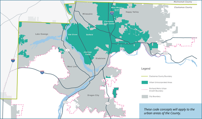
About the Study Area
The ZDO Diagnostic Report focuses on the urban unincorporated area of Clackamas County — communities that lie inside the Portland metropolitan Urban Growth Boundary (UGB) but outside the city limits of Portland, Milwaukie, Lake Oswego, Oregon City, or other municipalities. This area includes established neighborhoods like Oak Grove, Oatfield, and West Mount Scott, as well as employment corridors, the Clackamas Town Center area, and other urban places that look and function like cities but are governed as unincorporated county land. Together, these areas are home to tens of thousands of residents and are subject to the ZDO for everything from home additions to large commercial developments.
WHAT WE FOUND: SIX STRUCTURAL ISSUES
The diagnostic review identified six recurring structural and organizational issues that affect how the ZDO works in practice. These are not problems with the County's planning goals — those goals are sound and broadly supported. The issue is that decades of incremental updates have layered rules on top of rules, making the code harder to navigate, apply consistently, and keep as current than it needs to be.
- Fragmented Organization
The ZDO has grown through decades of incremental updates. Related standards are scattered across multiple chapters, and urban and rural regulations are woven together throughout — making the code slow and error-prone to navigate for applicants, staff, and the public. - Inconsistent Design Standards
The ZDO includes useful pedestrian-oriented and building design standards — but applies them unevenly. Standards requiring walkable, street-facing development appear in some plan areas but not others, producing different built outcomes from similar urban contexts. - Complex Density Calculation
The County's density methodology — which deducts constrained lands from buildable site area — is not widely used elsewhere in Oregon and can be difficult for applicants and the public to understand or predict. As state housing law continues to expand allowances, a simpler, more transparent framework will matter more. - Unclear Review Thresholds
Applicants and staff frequently struggle to determine when technical studies, frontage improvements, or concurrency reviews are required. Thresholds are embedded in multiple chapters rather than consolidated in one clear, logical location. - Connectivity Standards Fragmented
The ZDO supports walking, biking, and transit access in various sections — but block-length limits, pedestrian pathway requirements, and parking placement rules are not coordinated into a unified framework, limiting their collective effectiveness. - Limited Structural Resilience
Ongoing state housing and transportation legislation will continue to require ZDO updates. The current code's fragmented structure makes targeted amendments harder than they need to be — each change risks cascading across multiple disconnected chapters.
WHAT WE HEARD: ENGAGEMENT SUMMARY
The assessment was supported by an extensive public and stakeholder engagement process running from August 2025 through early 2026. Engagement was intentionally layered — sequenced to inform successive phases of technical analysis rather than conducted as a single one-time event — and designed to reach a broad range of participants.
- Staff Workshops
6 workshops across two rounds (Oct 2025 & Jan 2026) with current planners and permit staff - Housing Stakeholder Focus Group
Targeted session with housing developers, builders, and advocates - In-Person Open House
October 22, 2025 — public display and comment opportunity - Online Survey
Public and stakeholder comment opportunity open concurrent with open house - LEDIC Presentation & Discussion
February 2026 — Leadership in Equity, Diversity & Inclusion Committee
Four consistent themes emerged across all engagement activities:
- Code Usability & Clarity
Participants consistently described the ZDO as difficult to navigate and interpret. Many property owners and applicants couldn't predict whether a project would require additional review or trigger improvement obligations. - Flexibility in Urban Contexts
Stakeholders noted that the code often assumes large, undeveloped sites rather than the built-out urban parcels common in the County's urban unincorporated areas, creating friction for infill and redevelopment projects. - Environmental Complexity
Questions arose frequently around tree preservation, hazard overlays, and floodplain standards — areas where multiple layers of requirements interact in ways that are hard to disentangle without significant staff assistance. - Mixed-Use & Community Character
Respondents expressed both interest in expanded small-scale commercial flexibility near homes and concern about how new development would relate to existing neighborhood character. Both concerns point to the need for clearer, more objective standards.
FOUR DIRECTIONS FOR UPDATING THE CODE
The diagnostic findings point toward four strategic directions for updating the ZDO. These are not independent fixes — they work together as a framework for a more coherent, navigable, and adaptable code. Each direction emerged from both technical analysis and from what staff, stakeholders, and the public told us matters most.
- Usability and Clarity
Reorganize development standards into a consistent framework organized by scale — from community design and site layout to building form and design. Include usability tools: a code road map, unified use classifications, and a clear measurements section. - Simplify Housing Districts
Consolidate 18 residential zones into a smaller set of clearly-differentiated districts. Support middle housing types and ensure the code structure can accommodate ongoing state housing legislation. - Accommodate a Range of Employment
Streamline commercial and industrial districts and adopt a use classification framework that gives businesses clearer, more flexible pathways — including for hybrid and evolving use types. - Improve Neighborhood Connectivity
Create a unified framework for pedestrian, bicycle, and transit access standards. Consolidate block design, frontage, and access requirements — and integrate walkable design objectives in the Transportation Planning Rule.
01 STRATEGIC DIRECTION: Usability and Clarity
 The recommended update reorganizes development standards into a cohesive framework organized from large to small scale: community and site design, site planning and circulation, building placement and form, and building design standards. This structure — anchored in Sections 1005 through 1020 of the reorganized ZDO — creates a consistent, predictable sequence that applies across all urban zones and supports both administrative review and public understanding.
The approach which integrate elements of a form-based code shifts emphasis from what uses are allowed inside a building toward how a building relates to its surroundings — the street, the sidewalk, neighboring properties, and the public realm. This is not a switch or an either/or: it is a matter of calibration. The ZDO already contains useful tools for building placement, frontage design, and pedestrian-oriented development. The problem is that these tools are applied unevenly — and are scattered across the code in ways that make them hard to use.
Current Approach
Development standards are scattered across multiple chapters with no consistent sequence or scale logic. Applicants must cross-reference building placement rules in one chapter, parking requirements in another, and pedestrian access standards in a third. Similar urban contexts can produce very different outcomes depending on which zone applies.
Recommended Direction
A reorganized Section 1000 creates a layered framework from public realm → site design → building form → building design. The sequence is consistent across all urban zones, reducing the need for cross-referencing and making the code easier to read, apply, and update over time.
A form-based reorganization creates the structural backbone for a more usable code, making the ZDO genuinely easier to navigate. It also requires a set of companion tools that help users understand what the code says, where to find it, and how it applies to their project. Three of these tools are central to the recommended update.
- A Code Road Map
A new 'How to Use This Code' section, modeled on approaches from Ellensburg, San Antonio, and other jurisdictions, will give property owners, applicants, and the public a step-by-step orientation: what zone applies, what uses are allowed, what standards govern development, and what review process is required. This navigation layer makes the code accessible without changing what it requires. - Unified Use Classifications
The ZDO currently describes uses through long lists of specific activities in each zone district. The updated code will adopt a use category framework that groups related uses by their operational characteristics and impact rather than by specific name. This reduces the frequency with which emerging or hybrid uses fall outside any defined category, and gives applicants and staff a more predictable basis for project classification. - Consolidated Measurement Standards
Height, setbacks, lot area, density, and other dimensional criteria are currently measured using standards distributed across several chapters, with inconsistencies between them. A consolidated measurement section will establish uniform conventions that apply across the ZDO, reducing discrepancies between sections and making dimensional calculations more predictable for applicants.
The big picture: A form-based approach and a more usable code are two sides of the same coin. The structural reorganization makes it easier to write clear, objective standards. The navigation tools make those standards easier for everyone to find and apply. Together, they reduce the time and friction involved in the permitting process — for applicants, for staff, and for the public.
EMPHASIZE A FORM-BASED APPROACH

Land Use Based Approach: Residential, commercial, and employment uses are disconnected with abrupt edges between them, making it difficult to conduct daily routines without driving long distances. / Form-Based Approach (right): Uses are blended together with cohesive design standards, allowing for attractive and walkable neighborhoods where daily routines are easier and more convenient.
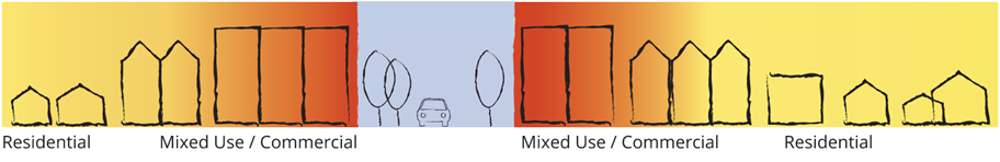
Form-Based Approach: Uses are blended together with cohesive design standards, allowing for attractive and walkable neighborhoods where daily routines are easier and more convenient.
02 STRATEGIC DIRECTION: Simplify Housing Districts
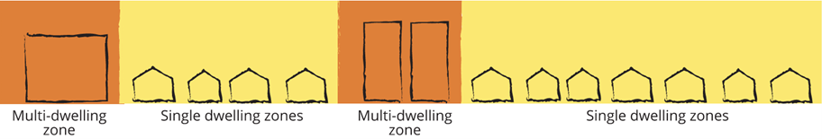
 The County currently maintains 18 separate urban residential zoning districts. Many differ only in lot size minimums, with nearly identical use permissions and overlapping density ranges. This proliferation adds administrative complexity without meaningfully expanding housing choices — and makes it harder to apply state-mandated middle housing allowances in a clear, consistent way.
Consolidating to four or five clearly-differentiated districts would reduce redundancy, align more closely with comprehensive plan land use designations, and create a more durable framework for supporting duplexes, triplexes, cottage clusters, and accessory dwelling units across the urban area. Oregon housing legislation — including HB 2001 and HB 2138 — has already required significant ZDO updates. A consolidated residential framework will be easier to keep aligned with future requirements as they continue to evolve.
18 Urban Residential Zones Today
Many low-density zones differentiated mainly by lot size minimums with nearly identical permitted uses. Medium-density zones with overlapping density ranges are difficult for applicants to determine which zone applies or predict what will be required. Complex to update consistently when state housing law changes.
Proposed Consolidation (~4–5 Districts)
Two consolidated low-density zones based on meaningful urban form thresholds. One medium-density zone for attached and small multifamily housing. One high-density zone for larger multifamily. Retained special districts for Regional Center and Village contexts where distinct design standards are warranted.
What this means in practice: Fewer zones with clearer purposes. Consistent design standards for middle housing types across all residential areas. A code structure that can absorb future state housing law changes without requiring a major overhaul. More options for homeowners, builders, and households looking for housing that fits their stage of life and budget.
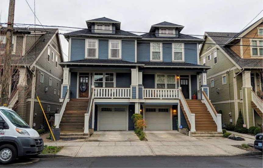
Conventional Residential Zones: A patchwork of many different residential zones, only allowing one type of housing, each with different rules but only minor differences between them, resulting in a complicated system that does not allow a variety of housing.
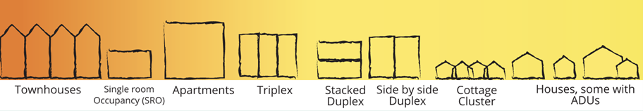
Adding Flexibility to Residential Zones: A more form-based approach to housing allows for more diverse housing types within the same building shape. Two or three units could exist in a building that looks like the single-family house next door.
03 STRATEGIC DIRECTION: Accommodate a Range of Employment Opportunities
 The ZDO's commercial and industrial framework was built around use categories that reflected how businesses operated decades ago. Today's employers increasingly don't fit cleanly into traditional bins: clean-tech firms blend manufacturing and research; food producers combine production with retail sales; health services occupy hybrid office-and-clinical spaces. When uses don't match the code's categories, even routine permits require staff interpretation — slowing approvals and creating unpredictability for businesses.
Two updates address this directly. First, a unified use classification framework, organized around the operational characteristics of businesses rather than specific named activities, will give applicants and staff a clearer, more flexible basis for classifying projects. Related uses will be grouped together, with defined characteristics and examples rather than exhaustive lists that struggle to keep pace with how industries evolve.
Second, the review framework for commercial and industrial development will be calibrated to scale. Clear, objective pathways should be available for the broad range of projects that don't pose significant impacts, reducing the frequency of discretionary Conditional Use review for projects that are straightforwardly consistent with the purposes of their zone. This same clarity benefits industrial lands, ensuring that the purposes of employment and industrial zones are maintained without unnecessary friction for compatible uses.
Current Approach
Long use lists in each district treat similar businesses differently depending on which specific activity is named. Hybrid or emerging uses often fall outside defined categories, requiring staff interpretation. Conditional Use review triggered even for projects consistent with zone purpose. Limited flexibility for businesses that blend use types.
Recommended Direction
A use classification framework groups uses by operational characteristics rather than specific names, making project classification clearer and more resilient to how industries evolve. Scaled review paths give straightforward, compatible projects a clear, objective route to approval. Industrial lands protected through consistent application of zone purposes.
What this means in practice: Faster, more predictable permit timelines for businesses. A classification framework that doesn't leave hybrid or emerging use types in ambiguous territory. Clear and objective approval processes for commercial and industrial projects that match zone purposes.

Industrial, Commercial, and Office Separation — Current zoning treats industrial, commercial, and office uses as separate and fixed, with little accommodation for hybrid or flexible space.

Employment Mixed-Use — The updated approach supports diverse employment formats, including small-scale production, live-work, and entrepreneurial activity, allowing a mix of employment types on a single site.
04 STRATEGIC DIRECTION: Improve Neighborhood Connectivity
 The ZDO includes standards that support walkability, biking, and transit access — but they are dispersed across multiple unconnected sections. Block-length limits appear in one chapter; pedestrian pathway requirements in another; parking placement rules in a third. Without a unified framework, similar sites in similar urban contexts can produce very different connectivity outcomes depending on which zone and which overlapping standards happen to apply.
When the State Transportation Planning Rule requirements were updated, new obligations for pedestrian-oriented design, drive-through facility restrictions, and parking location standards were added. Rather than appending these to the existing fragmented structure, the recommended update integrates standards into a consolidated connectivity and access framework — clarifying where requirements come from, when they apply, and what they require.
The updated framework also addresses transportation thresholds and concurrency, establishing tiered, scaled triggers for traffic impact analysis and clearer pathways for proportional mitigation. This is one of the most operationally significant changes for both applicants and staff, and one of the most consistent themes in what we heard across all engagement activities.
What this means in practice: Consistent standards for how development connects to sidewalks, neighboring properties, and daily destinations — schools, parks, transit stops, and neighborhood-serving retail. Parking sited to support rather than interrupt pedestrian movement. Block-length standards that ensure new development builds toward a connected network over time. Predictable, proportional traffic impact thresholds that don't require extensive research to understand.
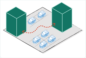
 Across the Site
Improve connectivity between buildings by creating safe, accessible pathways to encourage walkability and ease of movement
This could look like:
- Incorporating greenbelt walkways,
- Clearly marked pedestrian routes, and
- Designated paths through parking areas.
 Between Site
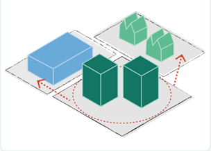
Enhance connectivity between sites by developing an integrated network of trails, greenbelt corridors, bike paths, pedestrian walkways, and sidewalks.
These improvements will promote safe, efficient, and enjoyable movement between the sites.
 To and From Key Destinations
Create safer, more reliable connections to and from key destinations through improvements to the street system, sidewalks, and bike paths, making everyday travel more accessible and safer for all users.
What are these key destinations?
- Schools
- Parks
- Shopping areas
- Grocery stores
- Transit stops
- Restaurants
Connectivity operates at three scales: within individual sites, between adjacent sites, and to and from daily destinations such as schools, parks, transit stops, and neighborhood-serving retail. The recommendation consolidates standards for all three into a single, navigable framework.
STATE LAW CONTEXT & NEXT STEPS
 A Note on State Law
Oregon has enacted a series of significant housing and transportation laws over the past several years that directly shape how the ZDO must function. These include requirements for middle housing in residential zones, Climate-Friendly and Equitable Communities (CFEC) standards for parking, pedestrian design, and transit-accessible development, and model code provisions under HB 2138 for building design and land division.

The ZDO largely accommodates current state requirements. The issue is structural: the code's fragmented organization makes it harder than necessary to implement targeted updates as state rulemaking continues. One of the most important long-term benefits of this reorganization is structural resilience — a code that can absorb ongoing state mandates without requiring a top-to-bottom overhaul each time rules change.
Key state frameworks shaping this update: HB 2001 (middle housing mandates) · HB 2138 (housing model code / bonus units) · Transportation Planning Rule walkable design objectives — parking reform, pedestrian design, transit access · Ongoing DLCD rulemaking
What Comes Next
This Diagnostic Report marks the end of the assessment phase and the beginning of code drafting. The action plan sequences amendments across three phases — organized by logical interdependency rather than relative priority. Foundational changes come first so that subsequent updates can build on a stable, coherent structure.
- PHASE 1: Development Standards Core
Reorganize Section 1000 into the form-based development standards framework. Integrate walkable urban design requirements. Update parking standards. Transition from DLA density to units-per-acre. Establish unified use classification framework. - PHASE 2: Code Organization & District Structure
Separate urban and rural zoning chapters. Consolidate residential zones and commercial districts. Clarify dimensional measurement standards. Reorganize transportation standards by applicability. Establish a new adjustment process. - PHASE 3: Transportation, Concurrency & Administration
Establish tiered traffic impact study and concurrency thresholds. Update procedural and design review frameworks. Add the ZDO Road Map and navigation tools — sequenced last so they reflect the full scope of changes adopted in Phases 1 and 2.
Community and Board Involvement: Draft amendments will be presented to the Planning Commission and Board of County Commissioners through a public hearing process. Additional public engagement will be structured to reach the full range of affected communities, with particular attention to groups identified through the LEDIC process as less likely to participate through traditional channels.
The full Diagnostic Report will be available on the County's project webpage.