Road Maintenance Projects

Routine Maintenance

Our maintenance team provides a variety of services year-round to keep our 1,400 miles of county roads safe, reliable and easy to navigate. 

110951

2,804 shoulder miles | September–July 
250 miles annually maintained 

  • Improves sight distance
  • Speeds up snow melt
  • Improves air flow and sun exposure
  • Reduces vehicle damage
110951

10,229 catch basins | January–December

  • Minimizes flooding
  • Protects road base
110951

2,000 shoulder miles | October–November, April–June
40 miles annually maintained  

  • Maintains water flow through drainage channels 
  • Prevents overflow
  • Controls erosion after heavy storms
  • Protects road base
110951

2,317 culverts, 4 miles of frontage pipe | January–December

  • Imitates natural water flow
  • Minimizes flooding
110951

21 miles | January–December

  • Supports traveler safety
  • Reduces risk of vehicles running off the road
  • Reduces risk of head-on crashes
110951

1,200 miles of yellow striping and 900 miles of white striping | July–October

  • Increased visibility, especially at night
  • Provides clear boundaries for all road users  
  • Protects turning traffic and reduces crashes
110951

2,845 lane miles | March–October

  • Prevents sinkholes 
  • Maintains integrity of road base 
110951

2,845 lane miles | January–December

  • Reduces road deterioration 
  • Reduces vehicle damage
  • Protects road base
110951

2,804 shoulder miles | September–July 1 

  • Improves visibility 
  • Improves access to shoulders and ditches for maintenance
  • Reduces chance of fire from vehicles on the side of the road or dragging chains 
     
110951

2,804 paved shoulder miles, 2,359 gravel shoulder miles | October–November, February–May

  • Reduces abrupt edges
  • Provides area outside travel lane to maneuver
  • Protects structural integrity of road edge
110951

2,381 manholes, 230 dry wells | January–December

  • Drains surface water
  • Filters water before entering larger drainage system
110951

69,808 signs at 16,543 locations | January–December

  • Controls traffic and provides safety for all road users 
  • Provides directions, caution and regulation information 
  • Evolves with road system to improve safety and efficiency
110951

165 traffic signals | January–December

  • Controls traffic and provides safety for all road users 
  • Adjusts signals in real-time based on traffic flow
  • Reduces congestion and maintains traffic flow
     
110951

564 lane miles | January–December

  • Allows for drainage of storm water
  • Reduces pollution, reduces drainage maintenance 
  • Improves safety, health and water quality
110951

Project description: Repair erosion on the western bridge footing and road embankment along Highway 211. Includes installing large wood and boulders, stream channel grading and native plants.

Updated: 8-17-2022

Schedule:

  • Project is moved to summer 2023. The project is planned to be completed between July 15- Aug. 31, 2023. Work is expected to take three weeks to complete.

Contact: Devin Patterson, Project Manager, devinpat@clackamas.us or 503-742-4666

Things to be aware of:

  • There may be delays of up to 20 minutes on Bonney Road and Highway 211, but a complete closure is not anticipated 
  • Site work limited to state approved in-water work window 

Current activities: 

  • Preparation of equipment and materials
  • Acquiring all required permits and approvals from local, state and federal regulatory agencies

Funding: 

  • County Road Fund

You may be interested to know: 

  • The bridge is a critical life line for residents, as this is the sole access to several homes
  • Planned repair measures are the minimum necessary to assure protection of the western bridge abutment, road embankment, and overall stability of the bridge, Bonney Road and State Highway 211
32806

Project description: Replace the existing bridge with a three-sided modular bridge. The project includes installing temporary access roads, removing the existing bridge, installing a new bridge, installing large-wood and boulder habitat, stormwater treatment, site grading, and installing riparian area plantings.

Updated: 3-17-2023

Status: Project plans, specifications and cost-estimates are complete. Preparing for construction. 

Schedule:

  • Site work will occur during the in-water work window sometime between July 15 and Aug. 31, 2023. This project is expected to take 6-8 weeks.

Contact: Devin Patterson, Project Manager, devinpat@clackamas.us or 503-742-4666

Things to be aware of:

  • A complete road closure is anticipated during bridge removal and replacement work. Delays of up to 20 minutes can be expected when single lane closures are possible. 

Current activities:

  • Preparing to award bid for construction

Funding:

  • $358,000 in grant funding received through the Oregon Watershed Enhancement Board
  • Project will be supplemented by county road funds
32806

Woodcock

Project description: Stabilize the low-flow channel in Woodcock Creek upstream of Wright Road, stabilize the high-flow spillway and the Wright Road Bridge structure, and reduce flood risk on Woodcock Creek upstream and downstream of Wright Road. The “Dave Phillips Bridge” is experiencing erosion around the high-flow spillway and on both bridge abutments. The project includes installing temporary access roads, installing erosion countermeasures, introducing logs for habitat enhancement, grading the historic and high-flow channels, and installing riparian area plantings.

Updated: 11-24-20

Status: Project has been cancelled due to significant cost increases associated with regulatory requirements. The bridge and roadway are stable.

Contact: Devin Patterson, Project Manager, devinpat@clackamas.us or 503-742-4666

32806

422nd Avenue Bridge over Cedar Creek | Sandy, OR

  • What: Reset retaining wall blocks on the SE corner of the bridge along Firwood Creek.
  • Why: To prevent erosion and to stabilize wall blocks and road fill.

Boardman Creek over Boardman Ave | Jennings Lodge, OR

  • What: Install a concrete footing and headwall, add boulders, rebuild a section of roadway, add native plants, and remove accumulated sediment and debris from Boardman Creek.
  • Why: To prevent future undermining and erosion, improve habitat, and to minimize flooding along Boardman Creek.

Casto Road Bridge over unnamed stream | Oregon City, OR

  • What: Remove remnants of an abandoned beaver dam on the upstream side of the bridge. 
  • Why: To assist with drainage and to keep the stream channel centered under the bridge.

Clackamas River Drive (culvert) over unnamed stream | Clackamas area, OR

  • What: Extend and repair a retaining wall on a concrete culvert which carries an unnamed tributary of the Clackamas River under Clackamas River Drive.
  • Why: During a storm event this past winter, a large tree fell and landed on the retaining wall on the culvert, damaging it significantly.

Creamery Creek (Hwy 170) Drainage Improvements

  • What: Excavate and remove sediment and invasive species from the west (downstream) side of the bridge. Creamery Creek flows under Hwy 170 approximately 900’ north of S Heinz Road.
  • Why: To assist with drainage and to keep the stream channel centered under the bridge, and to maintain a critical life line for area residents.

Folsom Road Bridge over unnamed, seasonal stream | Eagle Creek, OR

  • What: Excavate accumulated sediment and invasive species from the stream channel.
  • Why: To assist with drainage and to keep the stream channel centered under the bridge.

Heiple Road Bridge over Currin Creek | Eagle Creek, OR

  • What:  Excavate accumulated sediment and invasive species from the stream channel.
  • Why:  To assist with drainage and to keep the stream channel centered under the bridge.

Milk Creek over Winslow Road | Colton, OR 

  • What:  Raise Winslow Road Bridge to replace beam. During a routine Oregon Department of Transportation inspection, it was discovered that an exterior beam on the bridge has decayed and needs to be replaced.
  • Why: During a routine Oregon Department of Transportation inspection, it was discovered that an exterior beam on the bridge has decayed and needs to be replaced. 

Still Creek

  • What: Repair erosion and undermining on the eastern bridge footing and protect from future erosion. Includes creating a temporary access road and installing precast concrete panels and boulders along the affected bridge abutment and road embankment.
  • Why: To preserve and protect the Still Creek Bridge.

Tickle Creek Road Bridge over Tickle Creek | Boring, OR

  • What:  Repair erosion along the southern bridge footing, install erosion countermeasures, channel-grading, embankment protection, habitat enhancement and install native trees and shrubs.
  • Why:  To preserve and protect the bridge and embankment, and improve habitat for fish and wildlife. 
32806

A chip seal is a coating of liquid asphalt and rock chips applied to the existing roadway to extend the life of the pavement. There are four steps in the chip sealing process – applying an oil patch to the most degraded areas, putting down the chip seal, sweeping up excess rock chips and fog sealing (applying a thin coat of asphalt on top of the chip seal).

30991

Though your street is in basically sound condition, it needs routine maintenance to protect it. Chip sealing, which is effective for 7-10 years, stops water from seeping through the surface and damaging the pavement and road base. It costs less to apply chip seal to the street surface than to fix the street base if it is damaged.

30991

Once oil patches are applied, they are allowed to cure for one-two weeks before the chip seal is added. The sweeping and fog sealing are done as soon as possible after the chip seal, usually within 1-2 days based upon weather and the availability of work crews. While the surface can be driven or walked on at any stage, after the process is complete it takes about two weeks before the chip seal is firmly set.

30991

If it is raining or if rain is in the forecast, we will assign our crews to other work for the day. Chip seal must go on a dry surface. That is also why we ask that you make sure any sprinklers are turned off beginning at midnight the night before the chip seal work is scheduled.

30991

You will receive a notice at your door a few days ahead of time. If it does rain, work may be delayed.

30991

Please move your car off the street from the time the chip sealing begins to the completion of the fog sealing process – a period of approximately 2-3 days. You will always be able to drive through the area, but the entire street surface must be available for the work crews. Please also let family, friends and delivery people know not to park their vehicle on the street during that time period. If a vehicle is left on the street, we try to find the owner, but delays cost tax money. Therefore, cars not moved by the time the work begins will be towed at the owner's expense. If your car is towed, contact the Sheriff's Office, 503-655-8441.

30991

Bridge Maintenance

Our 186 bridges are inspected every 2 years and through those inspections we sometimes find repair and maintenance work that needs to be done to preserve the bridge structure and keep it safe for travelers. That work often includes bridge scour projects, either removing excess soil from stream channels or replacing soil around foundations that has been washed away during high water events.

32806

2,804 shoulder miles | September–July 
250 miles annually maintained 

  • Improves sight distance
  • Speeds up snow melt
  • Improves air flow and sun exposure
  • Reduces vehicle damage
110951

10,229 catch basins | January–December

  • Minimizes flooding
  • Protects road base
110951

2,000 shoulder miles | October–November, April–June
40 miles annually maintained  

  • Maintains water flow through drainage channels 
  • Prevents overflow
  • Controls erosion after heavy storms
  • Protects road base
110951

2,317 culverts, 4 miles of frontage pipe | January–December

  • Imitates natural water flow
  • Minimizes flooding
110951

21 miles | January–December

  • Supports traveler safety
  • Reduces risk of vehicles running off the road
  • Reduces risk of head-on crashes
110951

1,200 miles of yellow striping and 900 miles of white striping | July–October

  • Increased visibility, especially at night
  • Provides clear boundaries for all road users  
  • Protects turning traffic and reduces crashes
110951

2,845 lane miles | March–October

  • Prevents sinkholes 
  • Maintains integrity of road base 
110951

2,845 lane miles | January–December

  • Reduces road deterioration 
  • Reduces vehicle damage
  • Protects road base
110951

2,804 shoulder miles | September–July 1 

  • Improves visibility 
  • Improves access to shoulders and ditches for maintenance
  • Reduces chance of fire from vehicles on the side of the road or dragging chains 
     
110951

2,804 paved shoulder miles, 2,359 gravel shoulder miles | October–November, February–May

  • Reduces abrupt edges
  • Provides area outside travel lane to maneuver
  • Protects structural integrity of road edge
110951

2,381 manholes, 230 dry wells | January–December

  • Drains surface water
  • Filters water before entering larger drainage system
110951

69,808 signs at 16,543 locations | January–December

  • Controls traffic and provides safety for all road users 
  • Provides directions, caution and regulation information 
  • Evolves with road system to improve safety and efficiency
110951

165 traffic signals | January–December

  • Controls traffic and provides safety for all road users 
  • Adjusts signals in real-time based on traffic flow
  • Reduces congestion and maintains traffic flow
     
110951

564 lane miles | January–December

  • Allows for drainage of storm water
  • Reduces pollution, reduces drainage maintenance 
  • Improves safety, health and water quality
110951

Project description: Repair erosion on the western bridge footing and road embankment along Highway 211. Includes installing large wood and boulders, stream channel grading and native plants.

Updated: 8-17-2022

Schedule:

  • Project is moved to summer 2023. The project is planned to be completed between July 15- Aug. 31, 2023. Work is expected to take three weeks to complete.

Contact: Devin Patterson, Project Manager, devinpat@clackamas.us or 503-742-4666

Things to be aware of:

  • There may be delays of up to 20 minutes on Bonney Road and Highway 211, but a complete closure is not anticipated 
  • Site work limited to state approved in-water work window 

Current activities: 

  • Preparation of equipment and materials
  • Acquiring all required permits and approvals from local, state and federal regulatory agencies

Funding: 

  • County Road Fund

You may be interested to know: 

  • The bridge is a critical life line for residents, as this is the sole access to several homes
  • Planned repair measures are the minimum necessary to assure protection of the western bridge abutment, road embankment, and overall stability of the bridge, Bonney Road and State Highway 211
32806

Project description: Replace the existing bridge with a three-sided modular bridge. The project includes installing temporary access roads, removing the existing bridge, installing a new bridge, installing large-wood and boulder habitat, stormwater treatment, site grading, and installing riparian area plantings.

Updated: 3-17-2023

Status: Project plans, specifications and cost-estimates are complete. Preparing for construction. 

Schedule:

  • Site work will occur during the in-water work window sometime between July 15 and Aug. 31, 2023. This project is expected to take 6-8 weeks.

Contact: Devin Patterson, Project Manager, devinpat@clackamas.us or 503-742-4666

Things to be aware of:

  • A complete road closure is anticipated during bridge removal and replacement work. Delays of up to 20 minutes can be expected when single lane closures are possible. 

Current activities:

  • Preparing to award bid for construction

Funding:

  • $358,000 in grant funding received through the Oregon Watershed Enhancement Board
  • Project will be supplemented by county road funds
32806

Woodcock

Project description: Stabilize the low-flow channel in Woodcock Creek upstream of Wright Road, stabilize the high-flow spillway and the Wright Road Bridge structure, and reduce flood risk on Woodcock Creek upstream and downstream of Wright Road. The “Dave Phillips Bridge” is experiencing erosion around the high-flow spillway and on both bridge abutments. The project includes installing temporary access roads, installing erosion countermeasures, introducing logs for habitat enhancement, grading the historic and high-flow channels, and installing riparian area plantings.

Updated: 11-24-20

Status: Project has been cancelled due to significant cost increases associated with regulatory requirements. The bridge and roadway are stable.

Contact: Devin Patterson, Project Manager, devinpat@clackamas.us or 503-742-4666

32806

422nd Avenue Bridge over Cedar Creek | Sandy, OR

  • What: Reset retaining wall blocks on the SE corner of the bridge along Firwood Creek.
  • Why: To prevent erosion and to stabilize wall blocks and road fill.

Boardman Creek over Boardman Ave | Jennings Lodge, OR

  • What: Install a concrete footing and headwall, add boulders, rebuild a section of roadway, add native plants, and remove accumulated sediment and debris from Boardman Creek.
  • Why: To prevent future undermining and erosion, improve habitat, and to minimize flooding along Boardman Creek.

Casto Road Bridge over unnamed stream | Oregon City, OR

  • What: Remove remnants of an abandoned beaver dam on the upstream side of the bridge. 
  • Why: To assist with drainage and to keep the stream channel centered under the bridge.

Clackamas River Drive (culvert) over unnamed stream | Clackamas area, OR

  • What: Extend and repair a retaining wall on a concrete culvert which carries an unnamed tributary of the Clackamas River under Clackamas River Drive.
  • Why: During a storm event this past winter, a large tree fell and landed on the retaining wall on the culvert, damaging it significantly.

Creamery Creek (Hwy 170) Drainage Improvements

  • What: Excavate and remove sediment and invasive species from the west (downstream) side of the bridge. Creamery Creek flows under Hwy 170 approximately 900’ north of S Heinz Road.
  • Why: To assist with drainage and to keep the stream channel centered under the bridge, and to maintain a critical life line for area residents.

Folsom Road Bridge over unnamed, seasonal stream | Eagle Creek, OR

  • What: Excavate accumulated sediment and invasive species from the stream channel.
  • Why: To assist with drainage and to keep the stream channel centered under the bridge.

Heiple Road Bridge over Currin Creek | Eagle Creek, OR

  • What:  Excavate accumulated sediment and invasive species from the stream channel.
  • Why:  To assist with drainage and to keep the stream channel centered under the bridge.

Milk Creek over Winslow Road | Colton, OR 

  • What:  Raise Winslow Road Bridge to replace beam. During a routine Oregon Department of Transportation inspection, it was discovered that an exterior beam on the bridge has decayed and needs to be replaced.
  • Why: During a routine Oregon Department of Transportation inspection, it was discovered that an exterior beam on the bridge has decayed and needs to be replaced. 

Still Creek

  • What: Repair erosion and undermining on the eastern bridge footing and protect from future erosion. Includes creating a temporary access road and installing precast concrete panels and boulders along the affected bridge abutment and road embankment.
  • Why: To preserve and protect the Still Creek Bridge.

Tickle Creek Road Bridge over Tickle Creek | Boring, OR

  • What:  Repair erosion along the southern bridge footing, install erosion countermeasures, channel-grading, embankment protection, habitat enhancement and install native trees and shrubs.
  • Why:  To preserve and protect the bridge and embankment, and improve habitat for fish and wildlife. 
32806

A chip seal is a coating of liquid asphalt and rock chips applied to the existing roadway to extend the life of the pavement. There are four steps in the chip sealing process – applying an oil patch to the most degraded areas, putting down the chip seal, sweeping up excess rock chips and fog sealing (applying a thin coat of asphalt on top of the chip seal).

30991

Though your street is in basically sound condition, it needs routine maintenance to protect it. Chip sealing, which is effective for 7-10 years, stops water from seeping through the surface and damaging the pavement and road base. It costs less to apply chip seal to the street surface than to fix the street base if it is damaged.

30991

Once oil patches are applied, they are allowed to cure for one-two weeks before the chip seal is added. The sweeping and fog sealing are done as soon as possible after the chip seal, usually within 1-2 days based upon weather and the availability of work crews. While the surface can be driven or walked on at any stage, after the process is complete it takes about two weeks before the chip seal is firmly set.

30991

If it is raining or if rain is in the forecast, we will assign our crews to other work for the day. Chip seal must go on a dry surface. That is also why we ask that you make sure any sprinklers are turned off beginning at midnight the night before the chip seal work is scheduled.

30991

You will receive a notice at your door a few days ahead of time. If it does rain, work may be delayed.

30991

Please move your car off the street from the time the chip sealing begins to the completion of the fog sealing process – a period of approximately 2-3 days. You will always be able to drive through the area, but the entire street surface must be available for the work crews. Please also let family, friends and delivery people know not to park their vehicle on the street during that time period. If a vehicle is left on the street, we try to find the owner, but delays cost tax money. Therefore, cars not moved by the time the work begins will be towed at the owner's expense. If your car is towed, contact the Sheriff's Office, 503-655-8441.

30991
Contact for Bridge Maintenance
Department Staff
Kevin Morris
Transportation Maintenance Supervisor
503-650-3246

Pavement Rehabilitation

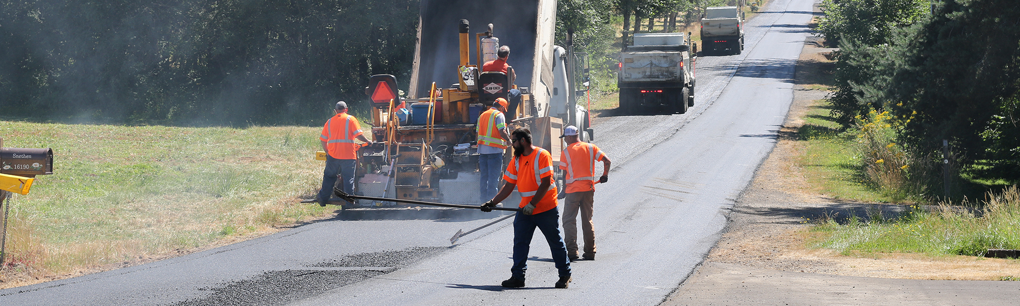
Pavement rehabilitation includes treatments that extend the life of an existing road surface such as surface sealants, patching short spans of roadway and asphalt paving. These proactive measures add structure to the road, remedy pavement distresses, and maintain a road's condition to defer full reconstruction further in the future. See schedule for next five years.

Scheduled pavement rehabilitation projects in unincorporated Clackamas County (schedule could change):

2023 projects

Canby area: 1.5 miles

  • Mulino Road: Township Road to Blundell Road

Clackamas Area: 2 miles

  • Andy’s Ct: Kaslin Wy to dead end
  • Brenda Ave: Roots Road to culdesac
  • Buser Ln: Clackamas Road to Murphy Ct
  • Crestwood Dr: Clackamas Road to culdesac
  • Jefferson St: Lark Ave to culdesac
  • Jefferson Ct: Jefferson St to culdesac
  • Kaslin Ct: Kaslin Way to culdesac
  • Kaslin Wy: Clackamas Road to dead end
  • Kelly Ct: Hood St to culdesac
  • Lark Ave: Clackamas Road to Roots Road
  • Murphy Ct: Hood St to culdesac
  • Patsy Ave: Roots Road to 15840 Patsy Ave
  • Thorville Ave: Clackamas Road to culdesac
  • Webster Ln: Webster Road to Brenda Avenue

Estacada area: 1.5 miles

  • Hillocksburn Road: OR 211 to Horner Road

Lake Oswego area: 1 mile

  • Fielding Road: Briarwood Road to 12770 Fielding Road
  • Pilkington Road: Childs Road to Dawn St
  • Red Wing Ct: Dawn St to culdesac
  • Tualata Ave: Jean Road to 18360 Tualata Ave
  • Colby Ct: Benfield Ave to culdesac 

Mulino area: 2.5 miles

  • Macksburg Road: Sprague Road to OR 213
  • Sprague Road: Molalla Ave to Macksburg Road

Rivergrove area: .3 miles

  • Dogwood Dr: 5742 SW Dogwood Dr to 5510 SW Dogwood Dr
  • Marlin Ave: Childs Road to Dogwood Dr
  • Tualamere Ave: Childs Road to Dogwood Dr

Our crews will also repair short spans of roadway throughout the county, including:

  • digging out and repaving rough pavement
  • sealing cracks
  • repairing slides


32866

2,804 shoulder miles | September–July 
250 miles annually maintained 

  • Improves sight distance
  • Speeds up snow melt
  • Improves air flow and sun exposure
  • Reduces vehicle damage
110951

10,229 catch basins | January–December

  • Minimizes flooding
  • Protects road base
110951

2,000 shoulder miles | October–November, April–June
40 miles annually maintained  

  • Maintains water flow through drainage channels 
  • Prevents overflow
  • Controls erosion after heavy storms
  • Protects road base
110951

2,317 culverts, 4 miles of frontage pipe | January–December

  • Imitates natural water flow
  • Minimizes flooding
110951

21 miles | January–December

  • Supports traveler safety
  • Reduces risk of vehicles running off the road
  • Reduces risk of head-on crashes
110951

1,200 miles of yellow striping and 900 miles of white striping | July–October

  • Increased visibility, especially at night
  • Provides clear boundaries for all road users  
  • Protects turning traffic and reduces crashes
110951

2,845 lane miles | March–October

  • Prevents sinkholes 
  • Maintains integrity of road base 
110951

2,845 lane miles | January–December

  • Reduces road deterioration 
  • Reduces vehicle damage
  • Protects road base
110951

2,804 shoulder miles | September–July 1 

  • Improves visibility 
  • Improves access to shoulders and ditches for maintenance
  • Reduces chance of fire from vehicles on the side of the road or dragging chains 
     
110951

2,804 paved shoulder miles, 2,359 gravel shoulder miles | October–November, February–May

  • Reduces abrupt edges
  • Provides area outside travel lane to maneuver
  • Protects structural integrity of road edge
110951

2,381 manholes, 230 dry wells | January–December

  • Drains surface water
  • Filters water before entering larger drainage system
110951

69,808 signs at 16,543 locations | January–December

  • Controls traffic and provides safety for all road users 
  • Provides directions, caution and regulation information 
  • Evolves with road system to improve safety and efficiency
110951

165 traffic signals | January–December

  • Controls traffic and provides safety for all road users 
  • Adjusts signals in real-time based on traffic flow
  • Reduces congestion and maintains traffic flow
     
110951

564 lane miles | January–December

  • Allows for drainage of storm water
  • Reduces pollution, reduces drainage maintenance 
  • Improves safety, health and water quality
110951

Project description: Repair erosion on the western bridge footing and road embankment along Highway 211. Includes installing large wood and boulders, stream channel grading and native plants.

Updated: 8-17-2022

Schedule:

  • Project is moved to summer 2023. The project is planned to be completed between July 15- Aug. 31, 2023. Work is expected to take three weeks to complete.

Contact: Devin Patterson, Project Manager, devinpat@clackamas.us or 503-742-4666

Things to be aware of:

  • There may be delays of up to 20 minutes on Bonney Road and Highway 211, but a complete closure is not anticipated 
  • Site work limited to state approved in-water work window 

Current activities: 

  • Preparation of equipment and materials
  • Acquiring all required permits and approvals from local, state and federal regulatory agencies

Funding: 

  • County Road Fund

You may be interested to know: 

  • The bridge is a critical life line for residents, as this is the sole access to several homes
  • Planned repair measures are the minimum necessary to assure protection of the western bridge abutment, road embankment, and overall stability of the bridge, Bonney Road and State Highway 211
32806

Project description: Replace the existing bridge with a three-sided modular bridge. The project includes installing temporary access roads, removing the existing bridge, installing a new bridge, installing large-wood and boulder habitat, stormwater treatment, site grading, and installing riparian area plantings.

Updated: 3-17-2023

Status: Project plans, specifications and cost-estimates are complete. Preparing for construction. 

Schedule:

  • Site work will occur during the in-water work window sometime between July 15 and Aug. 31, 2023. This project is expected to take 6-8 weeks.

Contact: Devin Patterson, Project Manager, devinpat@clackamas.us or 503-742-4666

Things to be aware of:

  • A complete road closure is anticipated during bridge removal and replacement work. Delays of up to 20 minutes can be expected when single lane closures are possible. 

Current activities:

  • Preparing to award bid for construction

Funding:

  • $358,000 in grant funding received through the Oregon Watershed Enhancement Board
  • Project will be supplemented by county road funds
32806

Woodcock

Project description: Stabilize the low-flow channel in Woodcock Creek upstream of Wright Road, stabilize the high-flow spillway and the Wright Road Bridge structure, and reduce flood risk on Woodcock Creek upstream and downstream of Wright Road. The “Dave Phillips Bridge” is experiencing erosion around the high-flow spillway and on both bridge abutments. The project includes installing temporary access roads, installing erosion countermeasures, introducing logs for habitat enhancement, grading the historic and high-flow channels, and installing riparian area plantings.

Updated: 11-24-20

Status: Project has been cancelled due to significant cost increases associated with regulatory requirements. The bridge and roadway are stable.

Contact: Devin Patterson, Project Manager, devinpat@clackamas.us or 503-742-4666

32806

422nd Avenue Bridge over Cedar Creek | Sandy, OR

  • What: Reset retaining wall blocks on the SE corner of the bridge along Firwood Creek.
  • Why: To prevent erosion and to stabilize wall blocks and road fill.

Boardman Creek over Boardman Ave | Jennings Lodge, OR

  • What: Install a concrete footing and headwall, add boulders, rebuild a section of roadway, add native plants, and remove accumulated sediment and debris from Boardman Creek.
  • Why: To prevent future undermining and erosion, improve habitat, and to minimize flooding along Boardman Creek.

Casto Road Bridge over unnamed stream | Oregon City, OR

  • What: Remove remnants of an abandoned beaver dam on the upstream side of the bridge. 
  • Why: To assist with drainage and to keep the stream channel centered under the bridge.

Clackamas River Drive (culvert) over unnamed stream | Clackamas area, OR

  • What: Extend and repair a retaining wall on a concrete culvert which carries an unnamed tributary of the Clackamas River under Clackamas River Drive.
  • Why: During a storm event this past winter, a large tree fell and landed on the retaining wall on the culvert, damaging it significantly.

Creamery Creek (Hwy 170) Drainage Improvements

  • What: Excavate and remove sediment and invasive species from the west (downstream) side of the bridge. Creamery Creek flows under Hwy 170 approximately 900’ north of S Heinz Road.
  • Why: To assist with drainage and to keep the stream channel centered under the bridge, and to maintain a critical life line for area residents.

Folsom Road Bridge over unnamed, seasonal stream | Eagle Creek, OR

  • What: Excavate accumulated sediment and invasive species from the stream channel.
  • Why: To assist with drainage and to keep the stream channel centered under the bridge.

Heiple Road Bridge over Currin Creek | Eagle Creek, OR

  • What:  Excavate accumulated sediment and invasive species from the stream channel.
  • Why:  To assist with drainage and to keep the stream channel centered under the bridge.

Milk Creek over Winslow Road | Colton, OR 

  • What:  Raise Winslow Road Bridge to replace beam. During a routine Oregon Department of Transportation inspection, it was discovered that an exterior beam on the bridge has decayed and needs to be replaced.
  • Why: During a routine Oregon Department of Transportation inspection, it was discovered that an exterior beam on the bridge has decayed and needs to be replaced. 

Still Creek

  • What: Repair erosion and undermining on the eastern bridge footing and protect from future erosion. Includes creating a temporary access road and installing precast concrete panels and boulders along the affected bridge abutment and road embankment.
  • Why: To preserve and protect the Still Creek Bridge.

Tickle Creek Road Bridge over Tickle Creek | Boring, OR

  • What:  Repair erosion along the southern bridge footing, install erosion countermeasures, channel-grading, embankment protection, habitat enhancement and install native trees and shrubs.
  • Why:  To preserve and protect the bridge and embankment, and improve habitat for fish and wildlife. 
32806

A chip seal is a coating of liquid asphalt and rock chips applied to the existing roadway to extend the life of the pavement. There are four steps in the chip sealing process – applying an oil patch to the most degraded areas, putting down the chip seal, sweeping up excess rock chips and fog sealing (applying a thin coat of asphalt on top of the chip seal).

30991

Though your street is in basically sound condition, it needs routine maintenance to protect it. Chip sealing, which is effective for 7-10 years, stops water from seeping through the surface and damaging the pavement and road base. It costs less to apply chip seal to the street surface than to fix the street base if it is damaged.

30991

Once oil patches are applied, they are allowed to cure for one-two weeks before the chip seal is added. The sweeping and fog sealing are done as soon as possible after the chip seal, usually within 1-2 days based upon weather and the availability of work crews. While the surface can be driven or walked on at any stage, after the process is complete it takes about two weeks before the chip seal is firmly set.

30991

If it is raining or if rain is in the forecast, we will assign our crews to other work for the day. Chip seal must go on a dry surface. That is also why we ask that you make sure any sprinklers are turned off beginning at midnight the night before the chip seal work is scheduled.

30991

You will receive a notice at your door a few days ahead of time. If it does rain, work may be delayed.

30991

Please move your car off the street from the time the chip sealing begins to the completion of the fog sealing process – a period of approximately 2-3 days. You will always be able to drive through the area, but the entire street surface must be available for the work crews. Please also let family, friends and delivery people know not to park their vehicle on the street during that time period. If a vehicle is left on the street, we try to find the owner, but delays cost tax money. Therefore, cars not moved by the time the work begins will be towed at the owner's expense. If your car is towed, contact the Sheriff's Office, 503-655-8441.

30991

Paving Projects Planned Five Years in Advance

Learn more about our 5-year pavement management plan.

Contact for Pavement Rehabilitation
Department Staff
Paving Hotline
503-650-3744

Pavement Preservation

To extend the life of a road, surface treatments are applied the existing roadways throughout the county including slurry seal and chip seal. A slurry seal is a coating of liquid asphalt; a chip seal is a coating of liquid asphalt and rock chips. See schedule for next five years.

Scheduled pavement preservation projects in unincorporated Clackamas County (timing could change):

2023 slurry seal projects

Overland Park and Southwood Park area: 7 miles 

  • 64th Ave: Jordan Ave to Laura Ave
  • 65th Ave: Clatsop St to Hazel Ave
  • 66th Ave: Jordan Ave to Needham St
  • 67th Ave: Alberta Ave to Clatsop St
  • 67th Ave: Overland St to Alder Pl
  • 70th Ave: Drew Ave to Sandview St
  • 70th Ave: Johnson Creek Blvd to Brehaut St
  • 70th Ave: Clatsop St to Alberta Ave
  • 72nd Ave: Drew Ave to dead end
  • 73rd Ct: Monroe Ave to 10811 73rd Ct
  • 74th Ave: King Road to Thompson Road
  • 74th Ave: Otty St to Overland St
  • 75th Ave: Jack St: 12169 75th Ave 
  • 76th Ave: Otty St to Overland St
  • 77th Ave: Thompson Road to Monroe St
  • 77th Ave: Otty St to Overland St
  • 78th Ct: Thompson Road to culdesac
  • 80th Ave: Johnson Creek Blvd to Clackamas St
  • Alder Pl: Linwood Ave to 65th Ave
  • Brehaut St: Bell Ave to 79th Ave
  • Brehaut St: 70th Ave to dead end
  • Clackamas St: 82nd Ave to 7736 Clackamas St
  • Eckler Ave: Lamphier St to Drew Ave 
  • Fern Ave: 67th Ave to 72nd St
  • Fern St: 62nd Ave to culdesac
  • Fir Ave: 72nd St to 67th Ave
  • Fir St: 65th Ave to dead end
  • Harrison St: 77th Ave to 78th Ave
  • Hazel St: 1057: 72nd St to 67th St
  • Imperial Ct: 74th Ave to 7363 Imperial Ct
  • Hazel St: 67th Ave to 62nd Ave
  • Imperial Ct: 74th Ave to culdesac
  • Jack Road: Linwood Ave to 70th Ave
  • Jack St: 74th Ave to 7313 Jack St
  • Jack St: 74th Ave to 75th Ave
  • Jordan Ave: Bell Ave to 64th Ave
  • Laura Ave: 66th Ave to Needham St
  • May St: Overland St to Bell Ave
  • Overland St: Bell Ave to Linwood Ave
  • Pierce St: Bell Ave to Eckler Ave
  • Queen Road: 70th Ave to Linwood Ave
  • Roslyn St: 80th Ave to 79th Ave
  • Snider Ave: Eckler Ave to Bell Ave
  • Steen Ct: Linwood Ave to 6282 Steen Ct
  • Thompson Ct: 77th Ave to culdesac
     

Happy Valley area: 13 miles 

  • 123rd Ct: Easthampton St to culdesac
  • 124th Ave: Easthampton St to dead end
  • 127th Ave: 13654 127th Ave to 13745 127th Ave
  • 127th Ave: culdesac to dead end
  • 130th Ave: 132nd Ave to Sunnyside Road
  • 130th Dr: Hubbard Road to 132nd Ave
  • 131st Dr: Hubbard Road to 132nd Ave
  • 133rd Ave: Scenic Ridge Dr to Normandy Dr
  • 141st Ave: 13921 141st Ave to culdesac
  • 144th: Princeton Village Wy to Oregon Trail Dr
  • Alimarie Dr: Ellen Dr to culdesac
  • Brackenbush Rd: 152nd Dr to Fontier Ave
  • Bridgeton St: 145th Ave to culdesac
  • Commanche Ct: 131st Dr to culdesac
  • Covington Road: Berksire Ave to Hemmen Ave
  • Easthampton St: 126th Ave to 122nd Ave
  • Frontier Ave: Territory Dr to Sieben Creek Dr
  • Gilesford St: Frontier Ave to Brackenbush Road
  • Huron St: 122nd Ave to 12258 Huron St
  • Katlin: 132nd Ave to Marci Wy
  • Marci Wy: Sierra Dr to culdesac
  • Morning Sun Dr: Sieben Creek Dr to Territory Dr
  • Ott St: 126th Ave to culdesac
  • Pioneer Dr: 152nd Dr to Frontier Ave
  • Princeton Village Wy: 142nd Ave to 145th Ave
  • Red Maple Ln: 142nd Ave to 141st Ave
  • Sieben Creek Dr: Territory Dr to Sieben Creek Dr
  • Sierra Dr: Marci Wy to dead end
  • Sierra Dr: Shannon View to Highpoint St
  • Sunnyview Ct: Sunnyview Dr to culdesac
  • Sunnyview Dr: 127th Ave to 129th Ave
  • Territory Dr 152nd Ave to Hines Dr

Damascus area: 13 miles 

  • 215th Ct: OR 212 to culdesac
  • Barkley Ct: OR 212 to culdesac
  • Belmont Ct: 232nd Dr to culdesac
  • Cielo Ct: dead end to culdesac
  • Edward Dr: Royer Road to 22000 Edward Dr
  • Heide Lane: Edward Dr to Cielo Ct
  • Karen Ct: Peggy Ann Dr to culdesac
  • Lansing Lane: Rust Wy to culdesac
  • Little Lane: Royer Road to Hiede Lane
  • Mercer Ct: 232nd Dr to culdesac
  • Naomi Ct: Ondo Rivera Dr to culdesac
  • Naomi Dr: Ondo Rivera Dr to dead end
  • Ondo Rivera Dr: 232nd Dr to culdesac
  • Peggy Ann Dr: Regner Terrace Dr to Karen Ct
  • Regner Terrace Dr: OR 212 to Sharon Dr
  • Rust Wy: OR 212 to culdesac
  • Sharon Dr: Naomi Dr to Rener Terrace Dr
  • Sharon Dr: Regner Terrace Dr to dead end

2023 chip seal projects

Estacada/Eagle Creek area

  • Coupland Road: Tracy Road to Divers Road
  • Coupland Road: Currin Road to Squaw Mtn Road
  • Coupland Road: Squaw Mtn Road to Tracy Road
  • Coupland Road: Currin Road to Moss Hill Road
  • Coupland Road: Moss Hill Road to Cemetery Road
  • Currin Road: Snuffin Road to Tracy Road
  • Currin Road: Tracy Road to Coupland Road
  • Davis Road SE: Tracy Road to dead end 
  • Divers Road: Coupland Road to Fallcreek Road
  • Dowty Road: OR 224 to Bonnie Lure Road
  • Dowty Road: Bonnie Lure Road to Bonnie Lure Bridge
  • Dowty Road: Bonnie Lure Bridge to Folsom Road
  • Duus Road SE: Eagle Creek Road to Currin Road
  • Eagle Creek Road: OR 211 to Keegan Road
  • Eagle Creek Road: Keegan Road to Currin Road
  • Eagle Creek Road: Currin Road to Ely Road
  • Eagle Creek Road: Ely Road to Hinman Road
  • Folsom Road: Dowty Road to Samuels Road
  • Folsom Road SE: Samuels Road to gate 
  • Folsom Road SE: Eagle Creek to OR 211/224
  • Folsom Road SE: OR 224 to Folsom Road
  • Heiple Road SE: Eagle Creek Road to OR 224
  • Heiple Road SE: OR 211/224 to Samuels Road
  • Keegan Road SE: Wildcat Mtn Road to Eagle Creek Road
  • Kemp Road SE: Squaw Mountain Road to Divers Road
  • Riverside Wy: Eaglecreek Road to 30575 Riverside Wy
  • Samuels Road: Heiple Road to Folsom Road
  • Snuffin Road: Davis Road to Currin Road
  • Surface Road SE: OR 224 to Tumala Mtn Road
  • Tracy Road: Currin Road to Coupland Road
  • Tumala Mountain Road: Coupland Road SE to Surface Road
  • Tumala Mountain Road: Surface Road to Divers Road
  • Wildcat Mtn Dr: Eagle Creek Road to OR 224
     

Wilsonville Hoodview Neighborhood

  • Baker Road: Mcconnell Road to 24050 Baker Road
  • Baker Road: Bell Road to Westfall Road
  • Baker Road: Westfall Road to Tooze Road
  • Baker Road: Tooze Road to Morgan Road
  • Baker Road: Mcconnell Road to Morgan Road
  • Tooze Road: Westfall Road to Baker Road
  • Tooze Road: Baker Road to Mcconnell Road
  • Malloy Wy: Tooze Road to Grahams Ferry Road
  • Westfall Road: Tooze Road to Baker Road
  • Westfall Road: Baker Road to 145th Ave
  • 145th Ave: Westfall Road to Tooze Road
  • Morgan Road: Baker Road to Tonquin Road


Chip Seal FAQ

30991

2,804 shoulder miles | September–July 
250 miles annually maintained 

  • Improves sight distance
  • Speeds up snow melt
  • Improves air flow and sun exposure
  • Reduces vehicle damage
110951

10,229 catch basins | January–December

  • Minimizes flooding
  • Protects road base
110951

2,000 shoulder miles | October–November, April–June
40 miles annually maintained  

  • Maintains water flow through drainage channels 
  • Prevents overflow
  • Controls erosion after heavy storms
  • Protects road base
110951

2,317 culverts, 4 miles of frontage pipe | January–December

  • Imitates natural water flow
  • Minimizes flooding
110951

21 miles | January–December

  • Supports traveler safety
  • Reduces risk of vehicles running off the road
  • Reduces risk of head-on crashes
110951

1,200 miles of yellow striping and 900 miles of white striping | July–October

  • Increased visibility, especially at night
  • Provides clear boundaries for all road users  
  • Protects turning traffic and reduces crashes
110951

2,845 lane miles | March–October

  • Prevents sinkholes 
  • Maintains integrity of road base 
110951

2,845 lane miles | January–December

  • Reduces road deterioration 
  • Reduces vehicle damage
  • Protects road base
110951

2,804 shoulder miles | September–July 1 

  • Improves visibility 
  • Improves access to shoulders and ditches for maintenance
  • Reduces chance of fire from vehicles on the side of the road or dragging chains 
     
110951

2,804 paved shoulder miles, 2,359 gravel shoulder miles | October–November, February–May

  • Reduces abrupt edges
  • Provides area outside travel lane to maneuver
  • Protects structural integrity of road edge
110951

2,381 manholes, 230 dry wells | January–December

  • Drains surface water
  • Filters water before entering larger drainage system
110951

69,808 signs at 16,543 locations | January–December

  • Controls traffic and provides safety for all road users 
  • Provides directions, caution and regulation information 
  • Evolves with road system to improve safety and efficiency
110951

165 traffic signals | January–December

  • Controls traffic and provides safety for all road users 
  • Adjusts signals in real-time based on traffic flow
  • Reduces congestion and maintains traffic flow
     
110951

564 lane miles | January–December

  • Allows for drainage of storm water
  • Reduces pollution, reduces drainage maintenance 
  • Improves safety, health and water quality
110951

Project description: Repair erosion on the western bridge footing and road embankment along Highway 211. Includes installing large wood and boulders, stream channel grading and native plants.

Updated: 8-17-2022

Schedule:

  • Project is moved to summer 2023. The project is planned to be completed between July 15- Aug. 31, 2023. Work is expected to take three weeks to complete.

Contact: Devin Patterson, Project Manager, devinpat@clackamas.us or 503-742-4666

Things to be aware of:

  • There may be delays of up to 20 minutes on Bonney Road and Highway 211, but a complete closure is not anticipated 
  • Site work limited to state approved in-water work window 

Current activities: 

  • Preparation of equipment and materials
  • Acquiring all required permits and approvals from local, state and federal regulatory agencies

Funding: 

  • County Road Fund

You may be interested to know: 

  • The bridge is a critical life line for residents, as this is the sole access to several homes
  • Planned repair measures are the minimum necessary to assure protection of the western bridge abutment, road embankment, and overall stability of the bridge, Bonney Road and State Highway 211
32806

Project description: Replace the existing bridge with a three-sided modular bridge. The project includes installing temporary access roads, removing the existing bridge, installing a new bridge, installing large-wood and boulder habitat, stormwater treatment, site grading, and installing riparian area plantings.

Updated: 3-17-2023

Status: Project plans, specifications and cost-estimates are complete. Preparing for construction. 

Schedule:

  • Site work will occur during the in-water work window sometime between July 15 and Aug. 31, 2023. This project is expected to take 6-8 weeks.

Contact: Devin Patterson, Project Manager, devinpat@clackamas.us or 503-742-4666

Things to be aware of:

  • A complete road closure is anticipated during bridge removal and replacement work. Delays of up to 20 minutes can be expected when single lane closures are possible. 

Current activities:

  • Preparing to award bid for construction

Funding:

  • $358,000 in grant funding received through the Oregon Watershed Enhancement Board
  • Project will be supplemented by county road funds
32806

Woodcock

Project description: Stabilize the low-flow channel in Woodcock Creek upstream of Wright Road, stabilize the high-flow spillway and the Wright Road Bridge structure, and reduce flood risk on Woodcock Creek upstream and downstream of Wright Road. The “Dave Phillips Bridge” is experiencing erosion around the high-flow spillway and on both bridge abutments. The project includes installing temporary access roads, installing erosion countermeasures, introducing logs for habitat enhancement, grading the historic and high-flow channels, and installing riparian area plantings.

Updated: 11-24-20

Status: Project has been cancelled due to significant cost increases associated with regulatory requirements. The bridge and roadway are stable.

Contact: Devin Patterson, Project Manager, devinpat@clackamas.us or 503-742-4666

32806

422nd Avenue Bridge over Cedar Creek | Sandy, OR

  • What: Reset retaining wall blocks on the SE corner of the bridge along Firwood Creek.
  • Why: To prevent erosion and to stabilize wall blocks and road fill.

Boardman Creek over Boardman Ave | Jennings Lodge, OR

  • What: Install a concrete footing and headwall, add boulders, rebuild a section of roadway, add native plants, and remove accumulated sediment and debris from Boardman Creek.
  • Why: To prevent future undermining and erosion, improve habitat, and to minimize flooding along Boardman Creek.

Casto Road Bridge over unnamed stream | Oregon City, OR

  • What: Remove remnants of an abandoned beaver dam on the upstream side of the bridge. 
  • Why: To assist with drainage and to keep the stream channel centered under the bridge.

Clackamas River Drive (culvert) over unnamed stream | Clackamas area, OR

  • What: Extend and repair a retaining wall on a concrete culvert which carries an unnamed tributary of the Clackamas River under Clackamas River Drive.
  • Why: During a storm event this past winter, a large tree fell and landed on the retaining wall on the culvert, damaging it significantly.

Creamery Creek (Hwy 170) Drainage Improvements

  • What: Excavate and remove sediment and invasive species from the west (downstream) side of the bridge. Creamery Creek flows under Hwy 170 approximately 900’ north of S Heinz Road.
  • Why: To assist with drainage and to keep the stream channel centered under the bridge, and to maintain a critical life line for area residents.

Folsom Road Bridge over unnamed, seasonal stream | Eagle Creek, OR

  • What: Excavate accumulated sediment and invasive species from the stream channel.
  • Why: To assist with drainage and to keep the stream channel centered under the bridge.

Heiple Road Bridge over Currin Creek | Eagle Creek, OR

  • What:  Excavate accumulated sediment and invasive species from the stream channel.
  • Why:  To assist with drainage and to keep the stream channel centered under the bridge.

Milk Creek over Winslow Road | Colton, OR 

  • What:  Raise Winslow Road Bridge to replace beam. During a routine Oregon Department of Transportation inspection, it was discovered that an exterior beam on the bridge has decayed and needs to be replaced.
  • Why: During a routine Oregon Department of Transportation inspection, it was discovered that an exterior beam on the bridge has decayed and needs to be replaced. 

Still Creek

  • What: Repair erosion and undermining on the eastern bridge footing and protect from future erosion. Includes creating a temporary access road and installing precast concrete panels and boulders along the affected bridge abutment and road embankment.
  • Why: To preserve and protect the Still Creek Bridge.

Tickle Creek Road Bridge over Tickle Creek | Boring, OR

  • What:  Repair erosion along the southern bridge footing, install erosion countermeasures, channel-grading, embankment protection, habitat enhancement and install native trees and shrubs.
  • Why:  To preserve and protect the bridge and embankment, and improve habitat for fish and wildlife. 
32806

A chip seal is a coating of liquid asphalt and rock chips applied to the existing roadway to extend the life of the pavement. There are four steps in the chip sealing process – applying an oil patch to the most degraded areas, putting down the chip seal, sweeping up excess rock chips and fog sealing (applying a thin coat of asphalt on top of the chip seal).

30991

Though your street is in basically sound condition, it needs routine maintenance to protect it. Chip sealing, which is effective for 7-10 years, stops water from seeping through the surface and damaging the pavement and road base. It costs less to apply chip seal to the street surface than to fix the street base if it is damaged.

30991

Once oil patches are applied, they are allowed to cure for one-two weeks before the chip seal is added. The sweeping and fog sealing are done as soon as possible after the chip seal, usually within 1-2 days based upon weather and the availability of work crews. While the surface can be driven or walked on at any stage, after the process is complete it takes about two weeks before the chip seal is firmly set.

30991

If it is raining or if rain is in the forecast, we will assign our crews to other work for the day. Chip seal must go on a dry surface. That is also why we ask that you make sure any sprinklers are turned off beginning at midnight the night before the chip seal work is scheduled.

30991

You will receive a notice at your door a few days ahead of time. If it does rain, work may be delayed.

30991

Please move your car off the street from the time the chip sealing begins to the completion of the fog sealing process – a period of approximately 2-3 days. You will always be able to drive through the area, but the entire street surface must be available for the work crews. Please also let family, friends and delivery people know not to park their vehicle on the street during that time period. If a vehicle is left on the street, we try to find the owner, but delays cost tax money. Therefore, cars not moved by the time the work begins will be towed at the owner's expense. If your car is towed, contact the Sheriff's Office, 503-655-8441.

30991
Contact for Pavement Preservation
Department Staff
Daryn Thorpe
Transportation Maint Tech, Sr.
503-722-6301

Phone:503-557-6391
Fax:503-650-3992
Email:roadconcerns@clackamas.us

McCoy Building 902 Abernethy Road Oregon City, OR 97045

Office Hours:

Monday to Thursday
7:30 a.m. to 5 p.m.
Friday
7:30 a.m. to 3 p.m.

After Hours:
503-655-8211