 Translate


Transportation Engineering
Transportation Engineering
Expanding transportation choice and access
To make travel safer and healthier in Clackamas County, we are developing tools and programs for travelers and employers. This set of tools, or travel options, will help expand awareness about transit services, recreational trails and carpooling to improve public health and reduce greenhouse gas emissions.
What does a travel options action plan do?
The plan will:
- Develop a suite of travel options for people in urban Clackamas County to broaden ways for people to travel without a vehicle.
- Identify new, innovative opportunities to improve mobility.
- Define strategies to help people use transportation networks and infrastructure more effectively without using a vehicle.
- Explore strategies to reduce congestion on roadways such as van pools, commuter shuttles, bike parking, vehicle parking policy and employer-provided reduced cost transit pass programs.
- Fulfill the travel options requirement of the transportation system plan for the State of Oregon
- Develop and implement a pilot program to improve mobility for targeted audiences in Clackamas County.
Project Area
All urban areas of Clackamas County are included in this analysis and action plan. The county will coordinate with cities about travel options in their specific areas.
Timeline
Steering Committee Members
| Name | Organization |
|---|---|
| Marne Duke | Metro |
| Kelsey Lewis | SMART (South Metro Area Regional Transit) |
| Darin Lund | TriMet |
| Ellen Rogalin | Clackamas County Public & Government Affairs (PGA) |
| Will Farley | City of Lake Oswego |
| Joseph Edge | Oak Grove Community Council |
| Kristina Babcock | Clackamas County Health, Housing & Human Services (H3S) |
| Sara Ford Oades | Clackamas Community College |
| Stephanie Miller | Oregon Department of Transportation |
| Sydney Cape | Get There Oregon |
| Nicole Perry | Street Trust |
| Leah Fisher | Clackamas County Public Health |
Related webpages
Contact
Department Staff
New Format?
Off
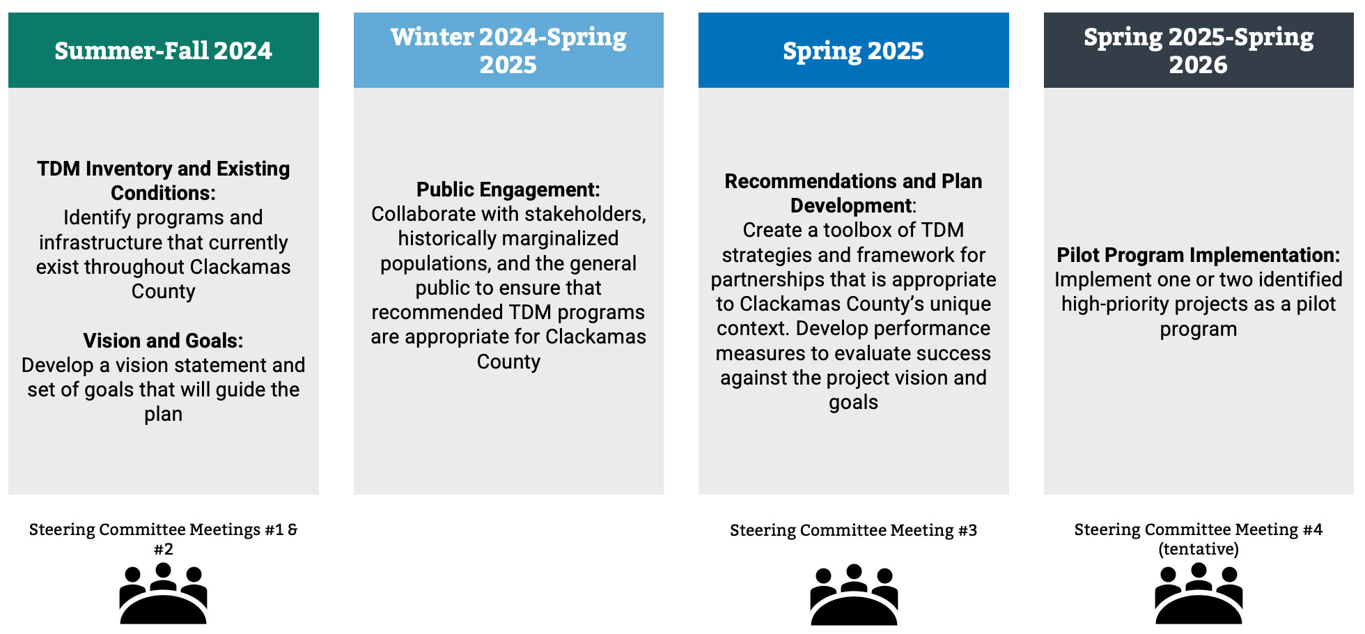
Clackamas River (Trolley Trail) Preliminary Design
Status
Design phase
Updated: Jan. 18, 2024
The need remains for a transportation link for people that walk and bike across the Clackamas River to connect the cities of Gladstone and Oregon City.
This phase of the project will identify a preferred bridge structure type and perform up to 30 percent engineering design. The bridge will replace the recently demolished Portland Ave Historic Trolley Bridge and connect the existing Trolley Trail, a shared-use path for bicyclists and pedestrians, to trails that exist along the Clackamas River on the Oregon City side of the river.
The bridge design continues the work completed in a previous feasibility study. Clackamas County is assisting the City of Gladstone through the design process using the county's ODOT certification.
Why
To improve active transportation access across the Clackamas River for pedestrians and bicyclists in the Gladstone and Oregon City areas.
Schedule
Design: March 2024 – Dec. 2026
Traffic impact
No traffic interruptions during design phase.
Current activities
Project design
Funding
- Project estimate $1.37 million
- Funding is provided from federal funds through the Metro 2022-24 Regional Flexible Fund Allocation Grant and from the City of Gladstone.
Bridge structure options
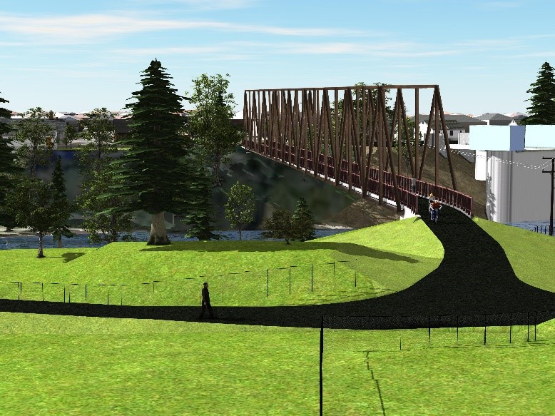
#1 Single-Span Steel Truss
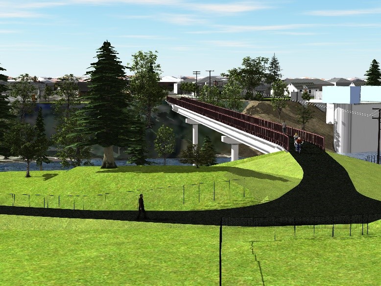
#2 Three-Span Precast Concrete Girder
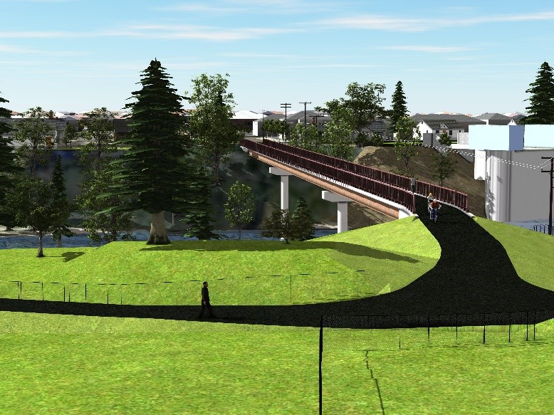
#3 Three-Span Steel Girder
Contact
Department Staff
New Format?
Off
Canby Ferry Ramp Improvements
Protecting the Canby Ferry and improving operations
Status
Design phase
Updated: Dec. 13, 2023
The north ramp landing for Canby Ferry traffic moves during significant water level changes on the Willamette River and disrupts ferry operations and can damage the bottom of the boat. The north ramp will be replaced and the south ramp stability will be evaluated.
Why
To protect the ferry structure and improve operations.
Schedule
- Design: fall 2024 to fall 2026
- Construction: summer 2027 to fall 2027
Traffic impacts
Expect delays or closures to ferry operations during construction.
Current activities
Project planning and solicitation of design services.
Funding
- Project estimate $550,000.
- Funding is provided from federal Ferry Boat Discretionary Program funds and county road funds.
Contact
Devin Patterson
Project manager
503-742-4666
New Format?
Off
Abernethy Creek (Holly Ln) Bridge Replacement
Status
Planning phase.
Updated: March 21, 2023
Ensuring all traffic can cross the bridge without weight restrictions.
The Abernethy Creek (Holly Lane) Bridge crosses Abernethy Creek in the Oregon City area. The bridge has weight restrictions for traffic due to deficiencies in the concrete deck, floor beam cracks, and weakness of the gusset plates and will be replaced to current design standards.
Why
To carry travelers without load restrictions for all traffic including emergency response and commercial truck traffic.
Schedule
- Design: Winter 2025 to Spring 2027
- Right of way: Winter 2026 to Spring 2027
- Construction: Spring 2027 to Winter 2028
Traffic impact
Expect delays or closures during construction.
Current activities
Waiting for funding agreement to initiate bid proposal for engineering design.
Funding
- Project estimate $1.4 million
- Funding is provided from the county road funds
New Format?
Off
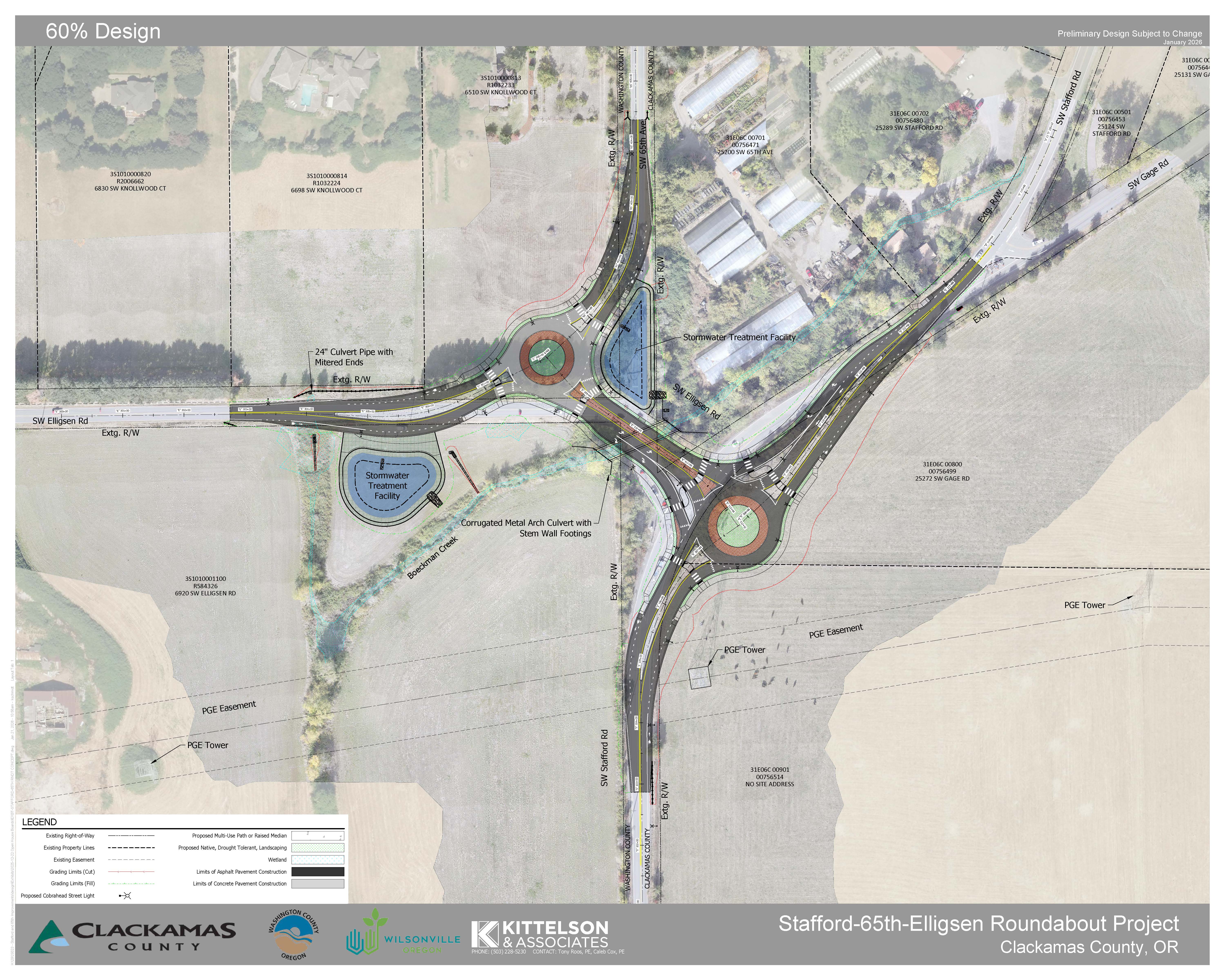
Stafford-65th-Elligsen Roundabout
Status
Design phase
Updated: Jan. 27, 2026
Convert the two intersections to two roundabouts, widen the travel lanes to 12 feet, and add bike lanes.
We will also replace the culvert at Boeckman Creek under the intersection with a fish passable culvert, and add stormwater facilities to treat water runoff.
Clackamas County is partnering with Washington County and the City of Wilsonville since the intersection spans multiple jurisdictions.
Proposed design for the two roundabouts.
Why
To reduce congestion and improve safety for all travelers, and provide safe passage for fish and other wildlife though waterways.
Schedule
- Project planning and design: Fall 2024 – Summer 2027
- Right of Way Acquisition Efforts: Spring 2026 – Summer 2027
All right of way acquisitions are conducted as required by state and federal law. Read right of way brochure: English | Spanish. - Construction: Winter 2027 – Spring 2029
Current activities
Stafford-65th-Elligsen roundabout open house, Feb. 10
5:30 to 7:30 p.m., Tuesday, Feb. 10
Wilsonville City Hall 29799 Town Center Loop E, Wilsonville, OR 97070Drop in anytime to learn more about the project and ask your questions to transportation experts at our second in-person open house. Our engineering design team has created a 60% level layout for your review after listening to questions and concerns at the first open house a year ago. The next step will be final refinements to project design, then we'll prepare the project to be posted for construction bid next year.
- Visit the virtual open house
- Refining the proposed improvement design, utility coordination, and environmental permitting.
Traffic impact
- Road closures are anticipated for a portion of this project. When construction work can safely occur with traffic, one lane will be closed at a time.
Funding
- Project estimate $14 million
- Funding is provided from Community Road Fund and Transportation System Development Charges, City of Wilsonville funds, and Washington County funds
Resources
- Flythrough animation video
- Presentation to Stafford Hamlet [video], Nov. 12
- Open house #1 documents
Contact Us
Department Staff
New Format?
On