 Translate




Transportation and Development
Transportation and Development
A Community Celebration: Shaping the Future of the Sunrise Corridor
On a fall evening in October at the Sunrise Water Authority, community members, volunteers, and local leaders came together to celebrate something special — a shared vision for the future of the Sunrise Corridor.
Leland-Beavercreek-Kamrath Intersection Improvements
Status
Engineering design
Updated: Sept. 4, 2026
Beavercreek, Leland, and Kamrath roads are two-lane roads with a travel lane in each direction. The intersection is located on a sharp curve resulting in poor visibility. In addition, a portion of the intersection provides extra space for drivers to cut through from Beavercreek Road onto Leland Road at high speeds.
Clackamas County completed a safety analysis and design study in 2024 for the Beavercreek Road/Leland Road/Kamrath Road intersection. The purpose of the study was to develop short- and long-term improvement concepts and recommend safety enhancements. While traffic analysis data shows expected crash rates at this intersection, there have been many complaints received over the years including concerns about serious accidents and near misses.
Short-term solution
- Reduce pavement width from the northwest corner to slow traffic down and improve visibility
- NW section of intersection - Install drivable concrete curbs with a hard surface behind the curbs to help redirect vehicles and to accommodate turning trucks and trailers while promoting slower speeds and greater safety
- Along WB Beavercreek – Centerline "rumble strips" and reflective recessed pavement markers are being added along Beavercreek Road east of the intersection to better guide westbound travelers taking left-turns onto Leland or Kamrath roads
- Relocate utility pole(s) to improve visibility and safety
- Add and improve signs and pavement markings to guide travelers

Long-term solution
- Design a roundabout to prevent serious crashes
Why
To reduce crashes and improve safety for all roadway users.
Schedule
- Project planning and design: June 2025 - March 2026
- Construction (short-term solution): September 2026 - December 2026
Traffic impacts
A full road closure is not anticipated for this project. Expect flagging and rolling single lane closures during construction between 7 a.m. and 6 p.m., Monday through Friday. While we do not expect the need to work on Saturdays, it may be necessary due to weather or other factors.
Current activities
- Construction preparation
Funding
- Project estimate $300,000
- Funding is provided from County Road Funds
Existing conditions
Examples of the project intersection are shown below.


What to expect during construction
- Construction creates noise, vibration and dust, and can disrupt normal neighborhood activity.
- Access to local businesses will be maintained, but construction may delay access.
- Expect traffic delays in and near the work area. Please observe traffic control signs and follow the directions of flaggers.
- On‐street parking will be restricted in and near the work area to create a safe work environment and to stage equipment and materials.
- Some equipment and materials may be stored on area streets overnight.
- There may be periods of inactivity between construction phases due to a variety of factors including weather, subcontractor schedules, cure time for materials and the availability of materials.
- A county inspector will be on-site during work hours and may be able to assist you with an immediate need during construction.
- Sewer, water and other utilities will remain in service during construction.
Staff contact
Jordan Cools, Project Manager
503-742-4654
jcools@clackamas.us
New Format?
Off
Boardman Creek flooding study
Status
Engineering study
Updated: Oct. 14, 2025
Studying conditions to reduce flooding of Boardman Creek
Clackamas County and Oak Lodge Water Services are studying ways and developing strategies to reduce flooding in the area along Boardman Creek between Naef Road and Boardman Ave.
Why
To minimize flooding along Boardman Creek at the Boardman Ave and Arista Dr intersection and nearby Trolley Trail.
Schedule
This is a study only. No funding has been identified for construction of a solution.
- Design: April 2025 to June 2026
Traffic impact
None.
Current activities
- Engineering design.
- Community feedback at Oct. 21 open house: You are invited to learn more about the flooding study and ask our engineering experts questions about ways flooding could be reduced in the neighborhood.
Drop in to the open house between 6:30-8 p.m., Tuesday, Oct. 21 at the Oak Lodge Water Services Technical Services Office, 14611 SE River Road, Oak Grove, OR 9726. See you there! - Open house resources
Funding
- Project estimate $99,970.
- Funding is provided from Clackamas County road funds and Oak Lodge Water District.
Staff contact
- Devin Patterson, project manager
- devinpat@clackamas.us
- 503-742-4666
New Format?
On
Transportation System Plan Update
Looking ahead to 2045
We are updating the Transportation System Plan (TSP) for unincorporated Clackamas County, and we need your help!
About every ten years, we review the progress we've made improving our transportation system and update our plan for the future. We will use updated data on how people and goods move through our county and where people live and work now and in the future, as well as ask community members about the types of transportation improvements they would like to see.
This information helps us as we consider the transportation changes that might be possible by 2045.
Public Outreach for Project Prioritization: What We Heard
For the past several months, project staff have been busy engaging with Clackamas County community members regarding their transportation priorities for this current TSP update.
Feedback from outreach during this period was focused on giving the project team a better understanding of which projects are important to specific communities – and why. The project team shared draft project lists for feedback and community members were encouraged to select their top priority transportation projects.
The feedback opportunities for community members included:
- 5 Public in-person open houses throughout the county
- 6-week long virtual open house and survey in 4 languages
- 2 Language or cultural focus groups (in-person)
- 6 Language or cultural focus groups (virtual)
- Phone and in-person conversations with community members
- 4 community walks
Through these feedback opportunities, project staff connected directly with over 279 people and 5,000 people viewed materials online.
When commenting on why respondents think certain projects should be adjusted up or down in priority and how it would support their future travel, respondents across the county shared a clear preference for elevating projects that improve conditions for people walking, rolling, riding a bicycle, and multimodal safety, especially where existed conditions are perceived as hazardous. This safety feedback aligns well with the corresponding final draft of the Transportation Safety Action Plan containing safety focused analysis, implementation strategies, actions, and performance measures to reduce fatalities and serious injuries in Clackamas County by 35% by the year 2035, with the hope to ultimately eliminate them by 2050.
Thank you for participating!
Thank you to everyone who participated in the summer 2026 public engagement; your feedback will help shape the future of transportation in Clackamas County!
What is a Transportation System Plan and why is it important?
Within Clackamas County, we have:
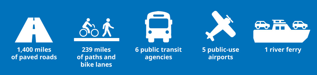
The TSP is a plan for our transportation system (all of the roads, intersections, bike lanes, sidewalks, and more) that looks 20 years into the future. It is made up of policies, programs, studies and projects that meet transportation needs for residents, businesses and visitors throughout Clackamas County. It's for all community members and all the ways we travel.
What has changed since the last TSP update in 2013?
The last countywide TSP was adopted in 2013. Since then, a lot has changed.
Population Changes
The county has seen a lot of growth—our population grew by approximately 13.6% from 2006-2010 to 2018-2022. Some areas grew at faster rates. We expect more growth in the next 20 years, but at a slower rate. ˜
Many Clackamas County communities have different transportation needs than they did in 2013, and demographic changes may have played a role. Our county is more diverse than it was a decade ago. Nearly a fifth of our population is under 18 years old. Unincorporated Clackamas County has a growing population of people over 65 years old. Making sure we can reach a variety of people – from urban to rural areas –to better understand transportation needs will be important as we update our plan.
New transportation infrastructure
Since 2013, several identified policies and over 140 projects have been implemented throughout the County. Projects include the Clackamas County Connects shuttles, Molalla River Bridge replacement, 82nd Drive/Jennifer Street signal replacement, Bilquist Elementary School sidewalks, and more. In addition, the County has established local transportation funding through the Community Road Fund.
New traffic data
With new projects and growth, travel patterns change and, of course, the number of travelers moving around the county increases. The new data helps us plan toward 2045.
New plans
We've also been hard at work on new plans that will be included in the TSP, such as: the Sunrise Corridor and Gateway Refinement Plan, Walk Bike Clackamas, and the Transit Development Plan and Transportation Safety Action Plan, which are also both being updated.
New rules
In 2022, new state transportation planning policies went into effect through the Transportation Planning Rule. These policies impact what types of projects and goals are legally required for new transportation projects. These factors all play a role in the need for an updated TSP.
Vision and Goals
Our community's vision and goals from 2013 have held strong over the last decade. Our Public Advisory Committee and the community gave feedback this winter and confirmed the following goals for developing the updated plan. These will guide which projects to prioritize for the next 20 years.
Vision: Building on the foundation of our existing assets, we envision a well-maintained and designed transportation system that provides safety, flexibility, mobility, accessibility and connectivity for people, goods and services; is tailored to our distinct geographies; and supports future needs and land use plans.
Safety and Health
Promote a transportation system that supports and improves our safety, health, and security.
Fiscal Responsibility
Promote a fiscally responsible approach to protect and improve the existing transportation system and meet future needs.
Local Business and Jobs
Plan the transportation system to promote a prosperous and adaptable economy and further the economic well-being of residents, businesses, visitors, and residents of the county.
Reduce Disparities
Reduce disparities in safe and reliable transportation between communities and key destinations.
Sustainable
Provide a transportation system that supports efficient use of resources and optimizes benefits to the environment, the economy, and
the community.
Livable and Local
Tailor transportation solutions, including policies, programs, and infrastructure projects, to suit the unique needs of local communities.
Who is involved in the 2045 TSP Update?
The TSP is influenced by people just like you! Beyond feedback from public events and surveys, there are several groups that will get into the details.
- All community members
We'll have opportunities for you to be engaged! - Project Management Team (PMT)
Guides the project and will make final recommendations to the County Planning Commission and Board of County Commissioners - Technical Advisory Committee (TAC)
Composed of agency staff from around the county and region to provide technical feedback on project deliverables. The TAC will advise the PMT. - Public Advisory Committee (PAC)
Composed of community members that represent a diversity of perspectives across the County. PAC members can help share their lived experience with moving around the county and help make sure we are engaging community members. The PAC will advise the PMT. Apply to be part of the PAC. - Geographic Subareas (GSAs)
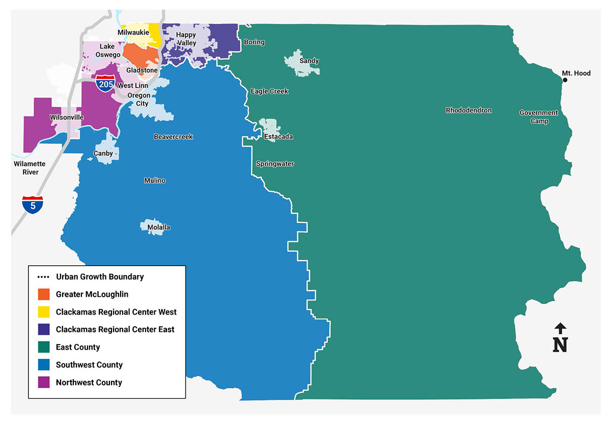
There are six geographic subareas within the County. Each GSA will have online meetings and an in-person workshop that will be open to anyone interested in that area. Input collected at GSA meetings and workshops will inform the other committees and Project Management Team. - Project Partners
We will closely coordinate with ODOT, Metro, our cities and neighboring counties, and associated transit agencies. The focus for the TSP is the unincorporated areas within the county.
Geographic Subareas (GSAs)
Because Clackamas County is so large, we've broken the work into 6 different geographic subareas (GSAs); each area has unique and differing needs and communities.
- East County
Near Sandy and Estacada - Greater Clackamas County Regional Center/Industrial Area – East
Near City of Happy Valley - Greater Clackamas County Regional Center/Industrial Area – West
Near City of Milwaukie - Greater McLoughlin Area
Near Gladstone and Clackamas - Northwest County
Near Wilsonville, Lake Oswego, and West Linn - Southwest County
Near Molalla, Canby, and Oregon City
Importance of Public Involvement
Public Involvement is a key aspect in the TSP update. Hearing from community members about their transportation needs is essential in creating long-lasting, safe, and efficient transportation networks. Clackamas County is committed to working with a diversity of audiences throughout this update, including:
- Youth
- Community members and residents – urban and rural
- Active Transportation Users (ex: people who walk, bike, or roll)
- Community leaders
- Business interests
- Underserved populations – we'll make extra effort to engage with people who we don't always hear from, including BIPOC communities, people with lower incomes, seniors, Limited English speakers, and people with disabilities that make it more difficult to interact with our existing transportation infrastructure
- Elected officials
Framework for Engagement and Decision-Making with Underserved Populations
In early 2025, the Department of Transportation and Development partnered with the Public Health Division to create the Framework for Engagement and Decision Making with Underserved Populations. This document outlines specific steps that can be taken to strengthen community engagement activities, increase participation, and provide tips and considerations to support engagement and decision-making with underserved populations.
Meetings
Contact
Jeff Owen
Project Manager
TSPupdate@clackamas.us
971-429-0813
Sign Up For Email Updates
New Format?
On